|
|
|
Climate Change and Development in the Gambia
|
SenegambiaThere is little written history about present day Senegambia before the arrival of Europeans around about 1450s. Before early Europeans, a number of independent kingdoms settled the area between the Senegal and Gambia Rivers. The Wolof and Sere Kingdoms primarily settled Western Senegal north of the Gambia River; the Jola and the Bainounkas inhabited Kombo. Around about AD 1000 people from the east, the Sarahule, Mandinka and Fula settled along the Gambia River in towns and villages and the Tukulor settled central and eastern Senegal. Portuguese were the first European sailors to arrive in the region in 1455. Until the 16th Century, the Portuguese monopolize trade along and between the Senegal and Gambia Rivers establishing trading posts in Saint Louis, Island of Goree in Senegal and Tancrowall (Tankular), Vintang (Bintang), Nyani Maru and Fata Tenda in the Gambia. Dutch, French and British displaced the Portuguese trading salt, iron, beads, firearms and gunpowder for ivory, ebony, beeswax, gold and slaves. Because of its navigability, the Gambia River became the preferred route to the African hinterland and James Island was developed to be the first European settlement in the Gambia. A fort was built on the Island to control the movement of ships in and out of the Gambia. At the same time St Louis was also settled to control trade in and out of the Senegal River. The French and British around displaced the Portuguese at the end of the 16th century. Banjul was settled in 1820 and a year later Britain declared the Gambia River a British Protectorate and acquired St Mary’s Island (Bathurst Island) and Lemaine Island (Janjanbureh Island) as crown lands and colonies. End of slave trade led to the introduction of groundnuts as main cash crop. The French settled Dakar in 1857 and constructed the railroad between St and Louis and Dakar in 1886. Round about the same time the Gambia became a crown colony and France and Britain drew the boundaries between Senegal. Between 1890 and 1900 both powers expanded their rule across the territories with the demarcation of the 740km border and violent confrontation with a number of Islamic rulers and Kingdoms.
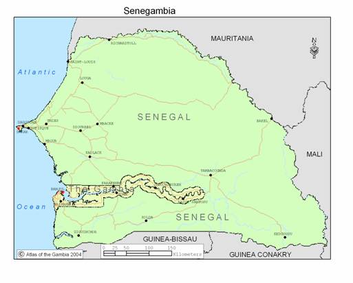
Figure 1. Major cities and towns of Senegambia The Gambia and Senegal grew further apart during the 20th Century resulting in dividing a number of border Kingdoms and settlements. Senegal gained independence from France in 1960 with the Gambia gained internal self-government from Britain in 1963 and complete independence in 1965. At independence attempts were made to reunite the two for fear of Gambia not being a viable state. These were quickly dropped due to lack of support from both sides. In February 1982, a few months after a bloody military coup was quelled by Senegal, the two agreed to form the Senegambia Confederation with the aim of promoting economic and cultural integration. The Confederation collapsed in September 1989 with the unilateral withdrawal of the Senegalese forces.
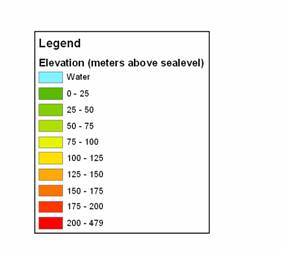
Figure. Elevation map of Senegambia. Elevation in meters above sea level. Much of the underlying geology of Senegambia is part of the tertiary continental terminal formation. Except for the southeast corner, topography is generally flat. Four major rivers the Senegal, the Saloum, The Gambia and the Cassamance dissect the region flowing into the Atlantic. The two main rivers, the Senegal and the Gambia both have their source at the Fouta Jallon highlands in the Republic of Guinea.
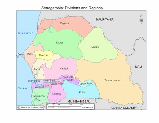
Modern political organization and administration within each country is highly based on the ways of the respective colonial powers. Administrative regions in Senegal are organized into Region and Arrondissment; and Divisions and Districts in the Gambia. Senegal has 11 administrative regions including Grand Dakar. The Gambia has 5 divisions plus Greater Banjul Area. The population of Senegambia in 2001 is estimated at 11,167,000. The most populous region in is the Dakar with over 2.4 million people. Greater Banjul, with a population of 357,000 is the most populous division in the Gambia. Table 1. Administrative Regions and Local Government Areas with populations
* Greater Banjul Area consists of the City of Banjul and Kanifing Municipal Council. |
|
Home | Up | Greater
Banjul Area | Western Division | Lower
River Division | North Bank Division | Central
River | Upper River |