Groundwater Geology of Long Island
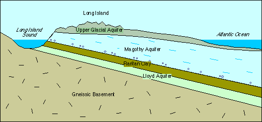
The three principal aquifers of Long Island are (top to bottom) the Upper Glacial Aquifer, the Magothy Aquifer, and the Lloyd Aquifer.
The uppermost geologic unit, the Upper Glacial Aquifer is composed of sediments deposited during the Pleistocene ice ages. The Harbor Hill Moraine and Ronkonkoma Moraine, which run the length of Long Island, are made of poorly sorted glacial till deposited at the glacial terminus (end). Between them and to the south are outwash plain deposits of sorted sands and gravels.
The Magothy Formation is composed of unconsolidated sands with some layers of silts and clays. The bottom 50 to 100 ft. is made of coarse sand and gravel. The formation is exposed in coastal bluffs on the north shore and dives down into the subsurface to a depth of about 600 ft. below sea level on the south shore. The Magothy Formation thickens seaward and is about 1000 feet thick in southwestern Suffolk County.
The Raritan Formation consists of an upper clay member and a lower sand member (Lloyd Sand). The clay member is a confining unit and the Lloyd Sand is a confined aquifer. The top of the Raritan (Lloyd) Aquifer is about 200 ft. below sea level beneath the north shore and dives down to about 1500 ft beneath the south shore. The Raritan Formation thickens seaward. Under Long Island the clay member has a maximum thickness of 300 ft and the Lloyd Sand has a maximum thickness of 500 ft.
The basement beneath Long Island is made principally of gneissic metamorphic rocks that formed during an early continental collision about 1 b.y. ago. A belt of metamorphic rocks that formed in the Grenville Orogeny underlies much of eastern North America. Exposures of this rock are found in the Bronx and Yonkers and in a belt running northeasterly through New Jersey into upstate New York.
Three other geologic units of local importance do not underlie all of Long Island.
In Kings and Southern Queens counties the upper glacial units are underlain by the Pleistocene Gardiners Clay (a confining unit) and Jameco Gravel (an aquifer).
On the south shore of Long Island, the upper Cretaceous Monmouth Group overlies and forms a confining unit for the Magothy Aquifer.
|
|
|
|
|
|
|
|
|
|
|
|
|
|
|
|
|
|
|
|
|
|
|
|
|
|
|
|
|
|
|
|
|
|
|
|