

THE PROJECT SITE
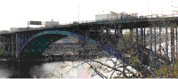
The probe development is located on the eastern edge of
Manhattan at Amsterdam Avenue, between 181st Street and
Interstate 95. The eastern edge of the Washington Heights
District rests on a plateau high above the Harlem River, and
is bounded by Highbridge Park. The site bears historical
significance in that it was the location of McNally Plaza, a
node which anchored the urban edge at 181st Street (Old
Highway One) and Amsterdam Avenue. McNally Plaza and a
prominent section of Highbridge Park were casualties lost
during the construction of the interstate highway system
during the early 1950's.
THE INTERSTATE 95 CORRIDOR
Washington Heights displays the evidence of the evolution
of the highway system as a distinct building typology. Prior
to the development of the extensive system we know of today,
regional highways were constructed between urban centers.
The Interstate highways on the other hand, were specifically
designed to bypass urban areas altogether. Washington
Heights was both bypassed and bisected, as the Interstate
separated the community from itself, the metropolitan, and
regional communities. Highway One, long forgotten as a
regional route, now serves as an exit ramp for I-95, as well
as local traffic.
One of the primary goals of this project was to reconsider
how the local community could be reconnected to the greater
metropolitan and regional areas via Interstate 95. By
utilizing 178th and 179th Streets as service roads for the
highway with new direct connections on the eastern side of
Manhattan, the primary north / south streets can be utilized
as a means of accessing the community directly, especially
the 181st Street Business Improvement District.
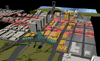
THE PROBE DEVELOPMENT
The strategic placement of the probe development on the
eastern edge of Washington Heights was chosen for the
following reasons: first, to bridge the gap between the
181st Street commercial area and Interstate 95; secondly, to
encourage new development along the eastern portion of 181st
Street and Amsterdam Avenue; thirdly, to redevelop
previously inaccessible areas of Highbridge Park, and
establish linkages to the Harlem River Drive quay; fourth,
to redevelop pedestrian and bicycle linkages to Central Park
and the Sherman Creek Marina along Harlem River; fifth, to
establish a metropolitan ferry stop on the Harlem River to
provide alternative access for commuters to the metropolitan
area.
The new commercial development is envisioned to incorporate
the following: first, a Metro Park and Ride facility for
commuters to access lower Manhattan via the subway / metro
ferry; secondly, to develop premium commercial office and
retail space on local, metropolitan, and regional levels;
third, to bolster the service-related businesses, and
provide jobs for the community by the creation of an easily
accessible "Gas / Food / Lodging" corridor along 178th and
179th Streets directly adjacent to Interstate 95.