
Stokes, I. N. Phelps The iconography of Manhattan Island 1498-1909 (v. 3)
(New York : Robert H. Dodd, 1915-1928.)
|
||

 Click here and hold to drag menu around
|


|
|
|
|
| Page [xiii] |
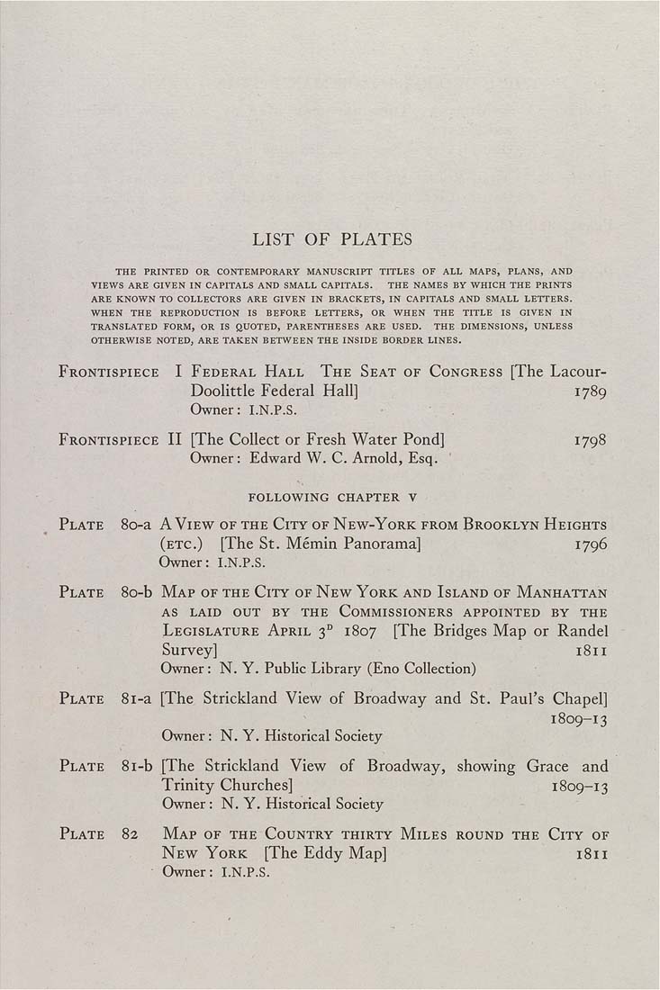
LIST OF PLATES THE PRINTED OR CONTEMPORARY MANUSCRIPT TITLES OF ALL MAPS, PLANS, AND VIEWS ARE GIVEN IN CAPITALS AND SMALL CAPITALS. THE NAMES BY WHICH THE PRINTS ARE KNOWN TO COLLECTORS ARE GIVEN IN BRACKETS, IN CAPITALS AND SMALL LETTERS. WHEN THE REPRODUCTION IS BEFORE LETTERS, OR WHEN THE TITLE IS GIVEN IN TRANSLATED FORM, OR IS ftUOTED, PARENTHESES ARE USED. THE DIMENSIONS, UNLESS OTHERWISE NOTED, ARE TAKEN BETWEEN THE INSIDE BORDER LINES. Frontispiece I Federal Hall The Seat of Congress [The Lacour- Doolittle Federal Hall] 1789 Owner: I.N.P.S. Frontispiece II [The Collect or Fresh Water Pond] 1798 Owner: Edward W. C. Arnold, Esq. following chapter V Plate 80-a A View of the City of New-York from Brooklyn Heights (etc.) [The St. Memin Panorama] 1796 Owner: I.N.P.S. Plate 80-b Map of the City of New York and Island of Manhattan AS LAID out by THE COMMISSIONERS APPOINTED BY THE Legislature April 3° 1807 [The Bridges Map or Randal Survey] 1811 Owner : N. Y. Public Library (Eno Collection) Plate 8i-a [The Strickland View of Broadway and St. Paul's Chapel] 1809-13 I Owner: N. Y. Historical Society Plate 8i-b [The Strickland View of Broadway, showing Grace and Trinity Churches] 1809-13 Owner: N. Y. Historical Society Plate 82 Map of the Country thirty Miles round the City of New York [The Eddy Map] 1811 Owner: I.N.P.S. i |
| Page [xiii] |