
Descriptive index of the maps on record in the office of the Register of City and County of New York (Descriptive index.)
(New York : Diossy & Co., 1875.)
|
||

 Click here and hold to drag menu around
|


|
|
|
|
| Page [13] |
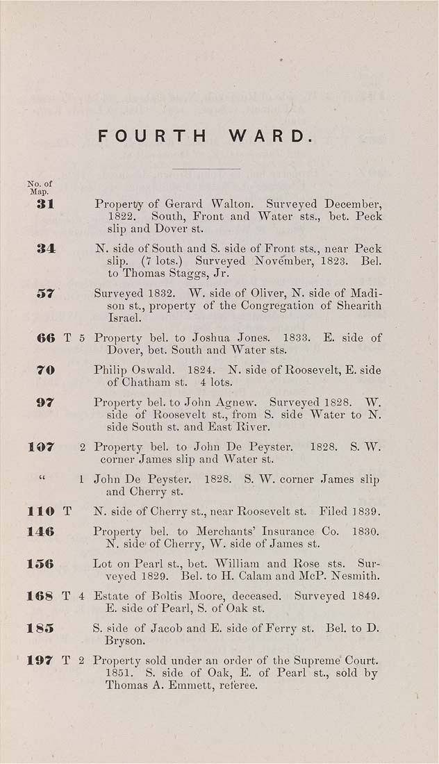
FOURTH WARD, No. of Map, 31 Property of Gerard Walton. Surveyed December, 1822. South, Front and Water sts., bet. Peck slip and Dover st. 34 N. side of South and S. side of Front sts., near Peck slip. (7 lots.) Surveyed jSTovember, 1823. Bel. to Thomas Staggs, Jr. 57 Surveyed 1832. W. side of Oliver, N". side of Madi¬ son St., property of the Congregation of Shearith Israel. 66 T 5 Property bel. to Joshua Jones. 1833. E. side of Dover, bet. South and Water sts. 70 Philip Oswald. 1824. N. side of Roosevelt, E. side of Chatham st. 4 lots. 07 Property bel. to John Agnew. Surveyed 1828. W. side of Roosevelt st., from S. side Water to IST. side South st. and East River. 107 2 Property bel. to John De Peyster. 1828. S. W. corner James slip and Water st. " 1 John De Peyster. 1828. S. W. corner James slip and Cherry st. 110 T N. side of Cherry St., near Roosevelt St. Filed ]839. 146 Property bel. to Merchants' Insurance Co. 1830. N. side- of Cherry, W. side of James st. 156 Lot on Pearl St., bet. William and Rose sts. Sur¬ veyed 1829. Bel. to H. Calam and McP. I^esmith. 168 T 4 Estate of Boltis Moore, deceased. Surveyed 1849. E. side of Pearl, S. of Oak st. 1 85 S. side of Jacob and E. side of Ferry st. Bel. to D. Bryson. 107 T 2 Property sold under an order of the Supreme Court. 1851. S. side of Oak, E. of Pearl st, sold by Thomas A. Emmett, referee. |
| Page [13] |