
Descriptive index of the maps on record in the office of the Register of City and County of New York (Descriptive index.)
(New York : Diossy & Co., 1875.)
|
||

 Click here and hold to drag menu around
|


|
|
|
|
| Page [39] |
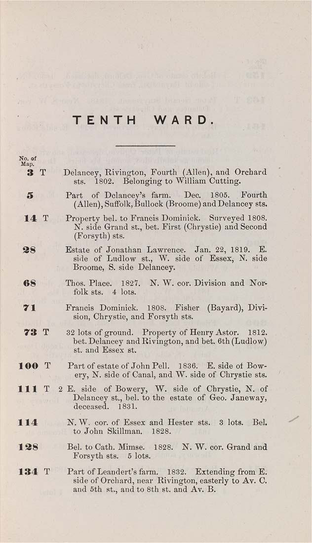
TENTH WARD No. ot Map. 3 T Delancey, Rivington, Fourth (Allen), and Orchard sts. 1802. Belonging to William Cutting. 5 Part of Dclancey's farm. Dec. 1805. Fourth (Allen), Suffolk, Bullock (Broome) and Delancey sts. 14 T Property bel. to Francis Doraiuick. Surveyed 1808. N. side Grand St., bet. First (Chrystie) and Second (Forsyth) sts. 38 Estate of Jonathan Lawrence. Jan. 22, 1819. E. side of Ludlow St., W. side of Essex, N. side Broome, S. side Delancey. 68 Thos. Place. 1827. N. W. cor. Division and Nor¬ folk sts. 4 lots. 71 Francis Dominick. 1808. Fisher (Bayard), Divi¬ sion, Chrystie, and Forsyth sts. 73 T 32 lots of ground. Property of Henry Astor. 1812. bet. Delancey and Rivington, and bet. 6th (Ludlow) St. and Essex st. 100 T Part of estate of John Pell. 1836. E. side of Bow¬ ery, N. side of Canal, and W. side of Chrystie sts. HIT 2 E. side of Bowery, W. side of Chrystie, N. of Delancey St., bel. to the estate of Geo. Janeway, deceased. 1831. 114 N.W. cor. of Essex and Hester sts. 3 lots. Bel, to John Skillman. 1828. 138 Bel. to Cath. Mimse. 1828. N. W. cor. Grand and Forsyth sts. 6 lots. 134 T Part of Leandert's farm. 1832. Extending from E. side of Orchard, near Rivington, easterly to Av. C. and 5th st., and to 8th st. and Av. B. |
| Page [39] |