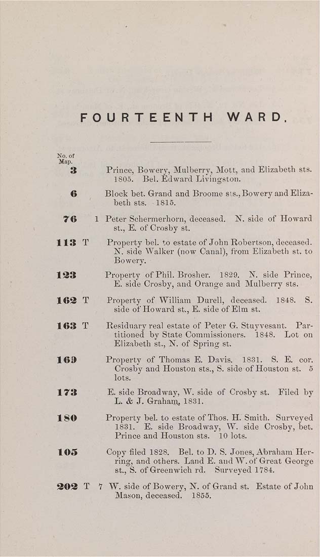
FOURTEENTH    WARD.


No. of


Map.


3


Prince, Bowery, Mulberry, Mott, and Elizabeth sts.
1806.    Bel. Edward Livingston.


6


Block bet. Grand and Broome sis.. Bowery and Eliza¬
beth sts.    1815.


76


1 Peter Schermerhorn, deceased. N. side of Howard
St., E. of Crosby st.


113


T


Property bel. to estate of John Robertson, deceased.
N. side Walker (now Canal), from Elizabeth st. to
Bowery.


133


Property of Phil. Brosher. 1829. N. side Prince,
E. side Crosby, aud Orange and Mulberry sts.


163


T


Property of William Durell, deceased. 1848. S.
side of Howard St., E. side of Elm st.


163


T


Residuary real estate of Peter G. Stuyvesant. Par¬
titioned by State Commissioners. 1848. Lot on
Elizabeth St., N. of Spring st.


16»


Property of Thomas E. Davis. 1831. S. E. cor.
Crosby and Houston sts., S. side of Houston St. 5
lots.


173


E. side Broadway, W. side of Crosby st. Filed by
L. & J. Grahaiit, 1831.


180


Property beL to estate of Thos. H. Smith. Surveyed
1831. E. side Broadway, W. side Crosby, bet.
Prince and Houston sts.    10 lots.


103


Copy filed 1828. Bel. to D. S. Jones, Abraham Her¬
ring, and others. Land E. audW. of Great George
St., S. of Greenwich rd.    Surveyed 1784.


303


T


7 W. side of Bowery, N. of Grand St. Estate of John
Mason, deceased.    1865.
|


