
Andreas, A. T. History of the state of Kansas (Supplementary History and Description of its Counties Cities Towns and Villages)
(Chicago : A.T. Andreas, 1883.)
|
||

 Click here and hold to drag menu around
|


|
|
|
|
| Page 308 |
308
HISTORY OF KANSAS.
DOUGLAS COUNTS'
I.CICATION AND NATURAL FEATURES.
DOUGLAS County is in the second tier west from ^Missouri. It is
bounded on the north by Jefferson and Jjeavenworth Counties; on
the east by Leavenworth and Johnson, on the south li\ Franklin, and ou
tbij west by (Isaije and Shawnee. The Kansas River runs along the
northern boundary of Lecompton, a part of Wakarusa and Eudora Town¬
ships. The boundaries of the county as organized by act of the First
Territorial Lei^islature, July. 18."i5, were defined as follows : " B(.'j,nnning
at the main channel of the Kaii'^as River, at the northwest coriuT uf John
sou County; thence south to tlie southwest cnrner of said Johnson Country ;
thence west twenty-four (34) miles, to a point f(|uidistaut between the
limits (embraced in the original plats) of the town.s of Lecompton and
Tccumscli. "
The present boundary of DouglasC'ount}' is as follows: (^ommeucing
at the northwest corner of Johnson_______________________________
County, in the middle of the main
channel of the Kansas River, thence
up the main channel of said Kansas
River to tlie southwest corner of
Leavenworth County ; thence north
on the west boundary line of Leaven¬
worth County to the north line of
Township 1- ; thence west on said
north line of Township 1'2 to the
middle of the main channel of the
Kansas Kiver ; theme up the main
channel of said river to the point
wher the line between the second and
third tiers of sections in Range IT
crosses said river ; thence south on the
section lines to the corner of Sec¬
tions 14, 15, 22 and i:5. in Town.ship 15
south, of Range 17 east; thence east
on section lines to the southwest cor¬
ner of Johnson County ; thence north
along the west line of Johnson
County to the place of be<;inning.
The Wakarusa River runs through
the -central part of the county from
west to cast, turns to the northeast in
Eudora Township, and empties into
the Kansas River. The county is
well supplied with springs, good well
water being obtained at a depth of
twenty-five feet.
About twenty per cent of the sur¬
face is bottom land, and eighty per
cent upland, the general surface of
the country being gently undulating
but occasionally breaking into abrupt
hills. The average width of the
bottoms is one mile. Ninety-four
per cent is open prairie, six per cent
forest, the timber belts ranging in
width from a few rods, to one mile.
The principal varieties of native
timber are the ash, Cottonwood, elm,
hackberry, oak and walnut. The
principal minerals found in the county
are an excellent quality of building
stone in great abundance, and fire and
pottery clay. Coal is believed to
exist in fair quantity and quality at
moderate depth ; but little or none has
yet been mined. The area of the
county is 300,160 acres, and there is very little waste land,
ceedingly fertile, and produces all the cereals, timothy, clo
grasses, and fruit and forest trees in great luxuriance.
EARLY SETTLERS.
Previous to May l.l, 18.W, the county was not open to settlement by
white people, being held by the Shawnee Indians as a part of their reser¬
vation under the treaty between them and the Government in 1825. On
the former date a new treaty went into effect, by the terms of which the
Shawnees reserved 200 acres to each member of the tribe, or 200,000 acres
in all, most of it in Johnson County. The most of that lying in Douglas
County selected by them under the" treaty was embraced in Eudora Town¬
ship, in the northeastern part of the county. As soon as the land was
thrown ojten to settlement, "squatters" came in from Missouri and from
the Western and Northwestern States to secure claims, the region, now
Douglas County, having been long known as a desirable location, from
the fact that one of the great highways of travel between the East and
I
-^i-ItM'-l,
R.XIX
1
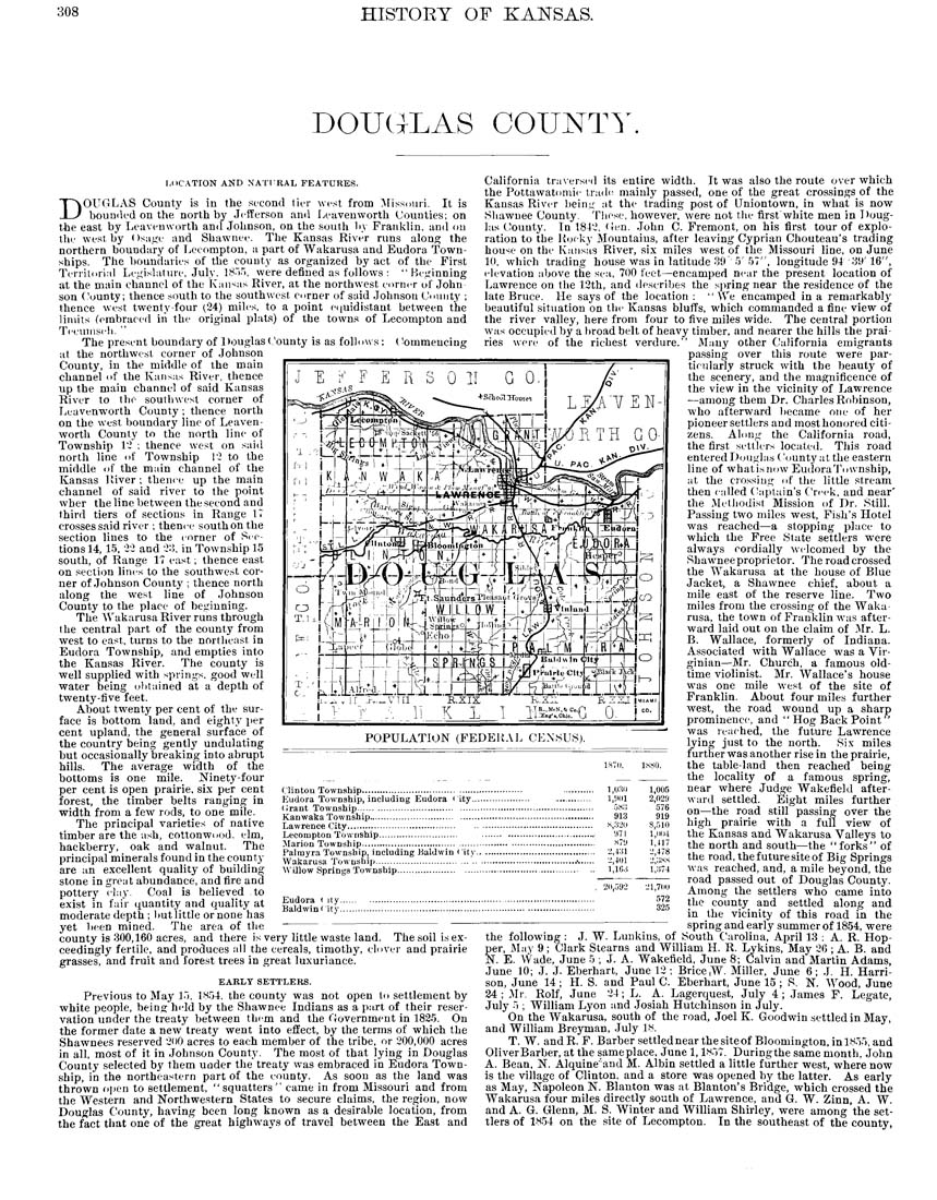
POPULATION (FEDEltAL CENSUS).
rlintou Township.......................................
f:udora Township, including Eudora city...
(Irant Township.......................................
Kanwaka Township....................................
Lawrence City.......................................
Lecompton Township...........................
^Marion Township.......................................
Palmyra Township, including Baldwin i ity.
Wakarusa Township.................................
Willow Springs Township.........................
Eudora < ity..
Baldwin City..
The soil is ex-
ver and prairie
California tra\erse(l its entire width. It was also the route over which
the Pottawatomie tracks mainly passed, one of the great cros.9ings of the
Kansas River beinij at the trading post of Uniontown, in what is now
Shawnee County. These, however, were not the first white men in Doug¬
las (Jouuty. In 184',!, (xen. John C. Fremont, on his first tour of explo¬
ration to the Kucky Mountaius, after leaving Cyprian Chouteau's trading
house on the Kansas River, six miles west of the Missouri line, on June
10, which trading house was in latitude 39 5'57", longitude 94'39'16",
elevation above the sea, 700 feet—encamped near the present location of
Lawrence on the 12th, and describes the spring near the residence of the
late Bruce. He says of the location: "We encamped in a remarkably
beautiful situation on the Kansas bluffs, which commanded a fine view of
the river valley, here from four to five miles wide. The central portion
was occupied by a broad belt of heavy timber, and nearer the hills the prai¬
ries were of the richest verdure." Many other California emigrants
___________________________ passing over this route were par¬
ticularly struck with the beauty of
the scenery, and the magnificence of
the view in the vicinity of Lawrence
—among them Dr. Charles Robinson,
who afterward became one of her
pioneer settlers and mo,9t honored citi¬
zens. Alon^' the California road,
the first settlers located. This road
entered Douglas t'ountyatthe eastern
line of whatisnow EudoraTownship,
at the crossing of the little stream
then called ('aptuin's Creek, and near'
the Metliodist Mission of Dr. Still.
Passing two miles west. Fish's Hotel
was reached—a stopping place to
which the Free State settlers were
always cordially welcomed by the
Shawnee proprietor. The road crossed
the Wakarusa at the house of Blue
Jacket, a Shawnee chief, about a
mile east of the reserve line. Two
miles from the crossing of the Waka¬
rusa, the town of Franklin was after¬
ward laid out on the claim of Jfr. L.
B. Wallace, formerly of Indiana.
Associated with Wallace was a Vir¬
ginian—Mr. Church, a famous old-
time violinist. Mr. Wallace's house
was one mile west of the site of
Franklin. About four miles further
west, the road wound up a sharp
prominence, and " Hog Back Point"
was reached, the future Lawrence
lying just to the north. Six miles
further was another rise in the prairie,
the table-land then reached being
the locality of a famous spring,
near where Judge Wakefield after¬
ward settled. Eight miles further
on—the road still passing over the
high prairie with a full view of
the Kansas and Wakarusa Valleys to
the north and south—the "forks" of
the road, the future site of Big Springs
was reached, and, a mile beyond, the
road passed out of Douglas County.
Among the settlers who came into
the county and settled along and
in the vicinity of this road in the
spring and early summer of 1854, were
the following : J. W. Lunkius, of South Carolina, April 13 : A. R. Hop-
er, J\Iay 9 ; Clark Stearns and William H. R. Lykins, May 26 ; A. B. and
E. Wade, June 5 ; J. A. Wakefield, June 8; Calvin and Martin Adams,
June 10; J. J. Eberh,art, June 12; Brice,W. Miller, June 6; J. H. Harri¬
son, June 14 ; H. S. and Paul C. Eberhart, June 15 ; S. N. Wood, June
24; Mr. Rolf, June 24; L. A. Lagerquest, July 4; James F. Legate,
July 5 ; William Lyon and .Josiah Hutchinson in July.
On the Wakarusa, south of the road, Joel K. Goodwin settled in May,
and William Breyman, .July 18.
T. W. andR. P. Barber settlednearthesiteof Bloomington,inlS55, and
OliverBarber, at the same place, June 1,1857. Duringthe same month, John
A. Bean, N. Alquine'and M. Albin settled a little further west, where now
is the village of Clinton, and a store was opened by the latter. As early
as May, Napoleon N. Blanton was at Blanton's Bridge, which crossed the
Wakarusa four miles directly south of Lawrence, and G. W. Zinn, A. W.
and A. G. Glenn, M. S. Winter and William Shirley, were among the set¬
tlers of 1854 on the site of Lecompton. In the southeast of the county,
1S7I).
1K80.
I.IWD
1,005
l,'.)(ll
2,029
.jSo
576
913
919
S,.'i2(.i
s,.';io
a7i
1,11114
s7y
1,417
•.:,i:n
2,478
2,401
2,:jHs
l.lO.i
1,:J74
ll,.J92
21,7110
572
325
§f
|
| Page 308 |