
Andreas, A. T. History of the state of Kansas (Supplementary History and Description of its Counties Cities Towns and Villages)
(Chicago : A.T. Andreas, 1883.)
|
||

 Click here and hold to drag menu around
|


|
|
|
|
| Page 1300 |
i-^oo
HISTORY OF KANSAS.
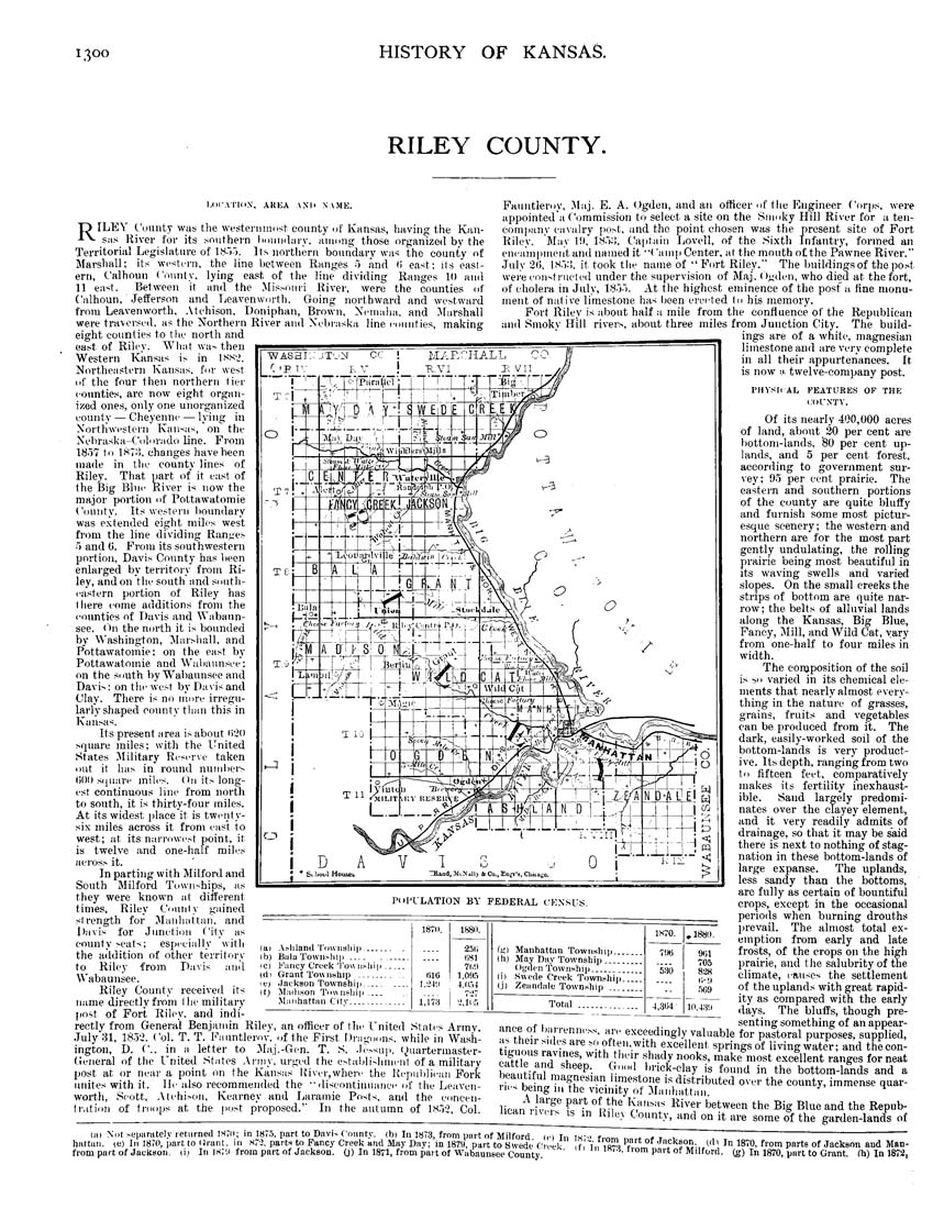
RILEY COUNTY.
MicA-ridX. AREA ANII NAMK.
T) ILEY CountT was the westeniinost county of Kansas, having the Kan-
-•■V sas River tor its southern liouiidary. aiiiong those organized by the
Territorial Legislature of IS.-ij. Its northern boundary was the county of
Marshall; its westi'rn, the line between Ranges i> and (i east; its easl¬
ern, Calhoun County, lying east of the line dividing Ranges 10 and
11 east. Between it and the .Mis>oiiri River, wero the counties of
Calhoun, JefEerson and Tjeavenworth. Going northward and westward
trom Leavenworth. .Vtchison, Doniphan, Brown, Xcnialia. and JIarshall
were traversed, as the J^"orthern River and Nebr.aslca line c-ounties, making
eight counties to ttie north and
east of Riley. Wliat wa^ then
Western Kansas is in iss-^.
Northeastern Kansas, for west
of the four then northern lier
counties, are now eight organ¬
ized ones, only one unorganized
county — Cheyenni— lying in
Northwestern Kansas, on the
Nebraska-Colorado line. From
1S^7 to IHTo. changes have been
made in thc county lines of
Riley. That part ot it east of
the Big Blue River is now the
major portion of Pottawatomie
County. Its westeni boundary
was extended eight miles west
from the line dividing Ranges
5 and 0. Prom its southwestern
portion, Davis County has lieen
enlarged by territory from Ri¬
ley, andon the south and south¬
eastern portion of Riley has
I here come additions from the
counties of Davis and Wabaun¬
see. (~in the north it is bounded
by Washington, ilarsliall. and
Pottawatomie: on the east by
Pottawatomie and Waliaunsce;
on the south by Wabaunsee and
Davis: on tlie west by Davis and
Clay. There is no more irregu¬
larly shaped county ttian this in
Kansas.
Its present area is about liill
srpiare miles: with the United
States Military Reserve taken
out it has in round numbers
(iOO sijuare mites. (In it,--long¬
est continuous line from north
to south, it is thirty-four miles.
At its widest plaee it is twenty-
six miles across it from east to
west; at its narrowest point, it
is twelve and one-half miles
across it.
In parting vvith Milford and
South Milford Townships, as
they were known at different
times, Riley County gained
strength for Maiiliattan, and
Davis for Junction City as
county seats; especially with
the addition of other territory
to Riley from Davis and
Wabaunsee.
Riley County received its
name directly from thc military
[jost of Fori, Rilcy. and indi-
rectly from General Benjamin Riley, an officer of the United States Army.
.July 31, 18.52. Col. T. T. Fauntleroy. of the Pirst Dragoons, while in Wash¬
ington, D. ('., in a letter to Jiaj.-Gcn. T. S. Jessuii, l^luartermaster-
Geiieral of the United States Aniiy, urged the establishment of a military
post at or near a point on the Kansas Kiver,where the Kepiililican Pork
unites with it. He also recommended the ■'discontinuance of the Leaven¬
worth, .Scott, .\tehison, Kearney and Laramie Posts, and the concen-
Ir.ition ot troops at the jiost proposed.'' In the autumn of IHoi, Col.
Fauntleroy, Maj. E. A. Ogden, and an officer of the Engineer Corps, were
appointed a Commission to select a site on the Smoky Hill River for a ten-
company caA'alry post, and the point chosen was the present site of Port
Kiley. May 10. bSo:!, Ca|itain Lovell, of the Sixth Infantry, formed an
encam|inieiitand named it •'('amp Center, at the mouth ofthe Pawnee River."
July 31), ISo:!, it took the name of " Fort Riley." The buildingsof the post
wei'e constructed under the supervision of Maj. Ogden, who died at the fort,
of cholera in July, 18oo. At the highest eminence of the post'a fine monu¬
ment of native liraestone has been erected lo his memory.
Fort Riley is about half a mile from the confluence of the Republican
and Smoky Hill rivers, about three miles from Junetion City. The build¬
ings are of a white, magnesian
limestone aud are very complete
in all their appurtenances. It
is now a. twelve-company post.
Piil'ULATION BY FEDERAL CENSUS
(ai Asliland 'I'ounsliij)
Ib) Bjilu Townslilp ...
IC) Kancy Creek Tow II
Itl 1 Grant Tow nship _
(e> -lackson Townshij)
Itj Madison Tounshij
Manhattiin Citv...
18TII.
tilG
l.->4'.l
1,1M
18811.
25li
liSl
7r,'.l
LOd.")
4.II.-I4
'i.ir.'i
Of its nearly 400,000 acres
of land, about 30 per cent are
liottom-lands, 80 per cent up¬
lands, and 5 per cent forest,
according to government sur¬
vey; 9.5 per cent prairie. The
eastern and southern portions
of the county are quite bluffy
and furnish some most pictur¬
esque scenery; the western and
northern are for the most part
gently undulating, the rolling
prairie being most beautiful in
its waving swells and varied
slopes. On the small creeks the
strips of bottom are quite nar¬
row; the belts of alluvial lands
along the Kansas, Big Blue,
Fancy, Mill, and Wild Cat, vary
from one-half to four miles in
width.
The eonjposition of the soil
is so varied in its chemical ele¬
ments that nearly almost every¬
thing in the nature of grasses,
grains, fruits and vegetables
can be produced from it. The
dark, easily-worked soil of the
bottom-lands is very product¬
ive. Its depth, ranging from two
til fifteen feet, comparatively
makes its fertility inexhaust¬
ible. Sand largely predomi¬
nates over the clayey element,
and it very readily admits of
drainage, so that it may be said
there is next to nothing of stag¬
nation in these bottom-lands of
large expanse. The uplands,
less sandy than the bottoms,
are fully as certain of bountiful
crops, except in the occasional
periods when burning drouths
prevail. The almost total ex¬
emption from early and late
frosts, of the crops on the high
prairie, and the salubrity of the
climate, causes the settlement
of the uplands with great rapid¬
ity as compared with the early
_________days. The bluffs, though pre¬
senting something of an appear-
exceedingly valuable for pastoral purposes, supplied,
t;,r,„.„. • '^ ^? Mteii. with excellent springs of living water; and the con-
„!.*?""'!™7T'.'.'^'*'^i'"''.'' shady nooks, make most excillent ranges forneat
PHYSIiAL
FEATURES OF
CIICNTV.
(ki Manhattan Townwhip..
(h) May Dii.y Township___
Ogden Township____
111 Swede Creek Toivnshij
(.i) Zeandale Town.ship ...
Total
4,31)1
, 1880.
901
705
838
li-ll
m9
ance of barrenni
as their sides ar
belntift'J'^ "^''^P- k'""' brick-Clay is found in" the'bottom"-'fands"'and a
, r heinl ?r"™- '™««t™f 1*^ distributed over the county, immense quar-
1 lis being 111 the vicmity of Manhattan.
A large part of the Kansas River between the Big Blue and the Eepub-
County, and on it are some of the garden-lands of
lican ri
vers is in Rilev
lal \»t seiiarately returned 1S?II; in 187.5, part to Davis County, (bi In 1873, from part of Milford ici Tn ik-o r..,^. TTT --------------------------------------------
hattaii. te) In 1870, part to lirant, in src, parts to Fancy Creek and May Day; in 1879, part to Swede Creek f,'-i„ la-l , •'"?'^i°Jl: <'!' I" 1870, from parts of .Tackson and Man-
frompart of Jackson, (i; In 1S7;) from part of Jackson, (j) In 1871, from part of Wabaunsee County ' '""''■'™™ P"'''of Milford. (g) In 1870, part to Grant, fh) In 1872,
|
| Page 1300 |