 4. High-Tech Paleontology |
Los Alamos scientist Roland Hagan was the first to propose a working plan for using applied technology to look for more of Sam's skeleton. In his lab he had a new piece of equipment designed for just the kind of problem I posed: locating shallow buried objects. He had designed the equipment specifically for locating the 55-gallon drums that might signify hazardous waste buried in a land-fill.
Roland told me that his "ground penetrating radar" equipment had been used already with some success at archaeological sites and that it might be useful at the new dinosaur locality. He asked for details about the bone and the rock: how large were the bones? what was their density and mineral composition? what was the nature of the sandstone surrounding the bones? would the skeleton be articulated? would there be iron or other metals concentrated in the bones? I couldn't answer any of these questions satisfactorily. But Roland threw himself into the project with enthusiasm.
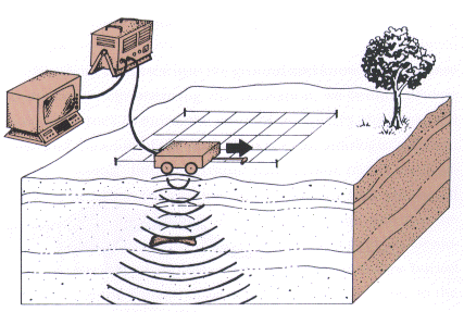 |
| Schematic of ground penetrating radar in operation. Successive traverses along a pre-established grid produce a succession of profiles. The profiles can be interpolated to construct a three-dimensional geometry of the most likely spots to look for bone. |
The device sends radio-frequency impulses into the ground; the reflections back to the surface are recorded for later analysis. The radar reflections mirror the layering in the subsurface. Under the right conditions the recorded data will indicate the presence of objects different from the surrounding matrix of rock.
I was enthralled with the idea of looking for more of Sam with this ground penetrating radar. I was also puzzled, however, because radar, as generally used, measures a time lapse between transmission and reception of the reflection. How could a stationary object beneath the ground generate a time lapse? The answer became evident to me later, when we began the experiments.
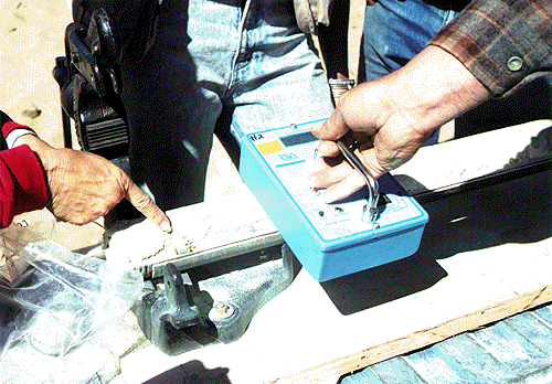
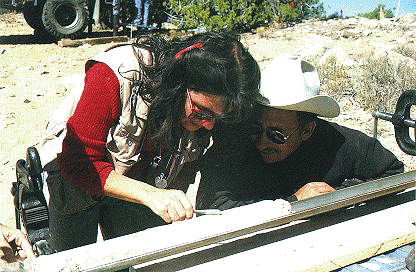
Making an early site visit to see Sam's burial, or what we hoped would be Sam's burial, Roland also brought colleagues from the lab. Don Neeper had agreed to help Roland experiment with the radar back at Los Alamos, to learn how it operates where they could be sure of the existence of something beneath the ground. Carrie Neeper would become the record-keeper; later she would also assume the role of historian for the project. During that site visit Roland collected a sample of bone fragment and a piece of the white sandstone for analysis, to determine their densities and physical properties. The radar would be useful only if there were sufficient difference between the bone and the rock.
Preliminary results were encouraging. The bone from the Ojito site proved denser than the rock. There was now good reason to believe that the radar should work--provided the bones were large enough to detect. Roland set about organizing a trial experiment on site, with a crew of volunteers.
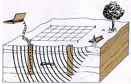
I had set a permanent reference point, a section of steel pipe pounded into a nearby crack in the sandstone at the edge of the mesa. This datum became the corner of our grid systems, laid out in meter squares. All trials in the remote sensing experiments would be recorded on fixed grids, and the excavation, wherever the bones would lead us, would be mapped on this reference grid. The grid mapping would allow us to compare and correlate data from all the experiments.
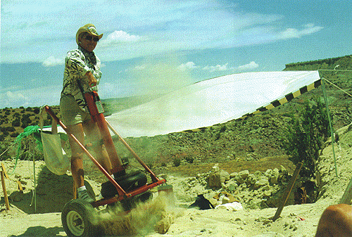
The day of the actual experiment, Roland and Don brought a portable generator to power the radar equipment. The sensor itself was easily portable--it was mostly an antenna and a recording device. The antenna simultaneously sent radio waves into the ground and received the reflections of those waves. The reflection data were recorded on continuous-feed paper, which produced a profile of the underground layers.
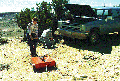 |
| Antenna for ground penetrating radar (Los Alamos National Laboratory), operated by Carrie Neeper (pulling the machine) and Roland Hagan. Powered by a generator, the antenna sends radio waves into the ground. |
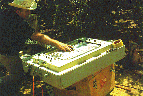 |
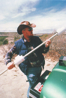
| Recorder for ground penetrating radar operated by Cliff Kinnebrew of Sandia National Laboratory. The lines mirror the layering in the subsurface. |
The antenna transmitted the impulses directly downward. To record the reflection profiles the antenna had to be pulled slowly across the surface of the ground. This was the answer to the puzzle: if the object being sought is fixed, then move the radar source . The effect is identical, because the time lapse is relative, produced from the relative difference in position between the antenna and the target. With its wheels and handle, the antenna looked more like a lawn mower than a high-technology apparatus searching for underground treasures. On each traverse along one of the grid lines the recorder produced a baffling picture of wavy lines, some pronounced, some subtle. The profiles resembled seismic records produced by seismographs.
What did the data mean? And how deep were these profiles anyway? We had no way of knowing, since we had not calibrated a known depth for reference. Ideally, each profile should have recorded reflections down to about fifteen or twenty feet beneath the mesa cap. Anything deeper would have contributed only noise. But we couldn't be sure whether these first records were on the mark, or whether they were reflecting density differences at too shallow or too great a depth.
We adjusted the scaling controls on the recorder, and worked the grid again. This round provided a more condensed profile than had the first trial and it clearly produced a record that penetrated much deeper into the ground. But how much deeper? We had records of the traverses, but we couldn't interpret them with confidence. We were learning, the hard way: by trial and error.
Roland had engineering friends at Sandia National Laboratory in Albuquerque, another research facility operated mainly for weapons development, including (then) much of the push for the Strategic Defense Initiative, or "Star Wars" technology. Wayne Cooke and Cliff Kinnebrew would bring their own ground penetrating radar equipment and their own crew-in-training to the site. Cliff and Wayne were optimistic; they routinely used radar to chart fault movements in underground vaults constructed in massive layers of salt in southern New Mexico for storage of hazardous wastes. They expected the radar to be equally effective in the search for dinosaur bones.
Rather than rolling their antenna over the uneven terrain, the Sandia engineers carried their antenna by two pairs of handles, as though it was mounted on a stretcher. Inching along a grid line in a slow and steady fashion, their antenna sent signals into the ground from a consistent height of about three feet above the surface. The Sandia team thus eliminated much of the interference produced by surface rocks and irregularities that jarred Roland's antenna on wheels.
Cliff pointed to a disturbance pattern on the recording chart as the two trainees moved along a particular grid line. The pattern curved upward through the reflection layers, then peaked and turned symmetrically downward in a parabolic curve. Having calibrated their instruments beforehand, the Sandia team, unlike the earlier team from Los Alamos, knew the depth of the layers that were represented on the chart. The parabolic disturbance pattern peaked on the chart at an eight-foot depth.
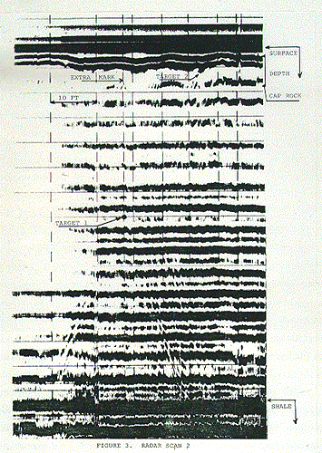 |
| Radar sensing results. This printout records one of the radar tests at the Seismosaurus site by Sandia National Laboratory volunteer scientists. The peak of the parabolic disturbance pattern marks the depth and grid position of something of different density from the surrounding rock. A change in density causes a change in timing of reflection, and hence a shift in the reflection profiles. We interpreted this "target" (at the expected depth of eight feet) as probable bone. |
That was exactly where the upper surface of a bone two feet in diameter should be positioned. Eureka! I thought to myself, barely able to contain my excitement. We had struck paleontological gold. Rather, there was a good chance that we had. The only way to verify success was to dig. The disturbance pattern could, after all, have been generated by something else--perhaps a pocket of water-saturated sediment coincidentally at a depth of eight feet, or possibly the trace of one of the minor faults that riddled the sandstone.
Ever the optimist, I was convinced we had found bone. I wanted to cart out the pickaxes and shovels right then. That, however, was a ridiculous idea. My friends wisely persuaded me to settle for a cautious celebration of beer and New Mexico tamales.
We collected the radar profiles for more detailed evaluation. Roland, Don, and Carrie would compare the data generated by the two different experiments, Sandia versus Los Alamos, and try to predict where bones might be positioned underground.
On the same day that Roland and Don first brought out the radar equipment, they invited two other colleagues from the lab: engineer Harold Bowen and technician Rod Hardee. Harold came with a huge, floppy straw hat; Rod came with a keen imagination. Rod began almost immediately to regale us with fantastic stories about the possible meanings of the nearby petroglyphs. But they did a good job of explaining to me the kind of equipment they'd like to try on the site and the theory behind it.
My interest was piqued when Harold told me a device exactly like his had discovered the wreckage of the Atosha , a Spanish galleon laden with treasures that sank in the Caribbean. Harold was rather obsessed with galleons--the ultimate dream of treasure hunters, who can expect to share in the riches if they are on the discovery teams. He and Rod now became obsessed with finding Sam's bones, as if Sam were a ship buried in the ancient sands of time. The treasure they would share would be the joy of discovery; they threw themselves into the search with gusto.
 |
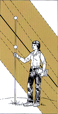
| The assembly of the pole and sensors for proton free-precession magnetometry operated by Phil Vergamini, Los Alamos National Laboratory. Harold Bowen, also of Los Alamos National Laboratory, built the prototype and adapted it specially for locating Sam's bones. The sensors (the knobs on the pole) receive and measure the strength of the magnetic field at that position above the ground. |
Harold's device for Proton Free-Precession Magnetometry was deceptively simple. Indeed, he had built it as a prototype, without all the bells and whistles that a final version might include. The magnetometer is not a metal detector. Instead, it measures the intensity of the magnetic field of the earth at a given point. With its sensor mounted eight feet up from the ground on a hand-held pole, the magnetometer would record the magnetic field eight feet above the patch of ground directly below. Technically, the magnetometer measures the deflection of protons in response to the precise intensity of the magnetic lines of force. And it was precise, almost beyond belief: it could measure differences as small as one millionth the intensity of the earth's magnetic field.
Now, consider the earth's magnetic field emanating from points near the two geographic poles. The field lines enter the ground vertically at the North and South magnetic poles and horizontally at the equator. At middle latitudes in the northern hemisphere, the lines of force enter the earth, everything else being equal, at an inclination of about 45 degrees, slanting downward to the north. But everything else is not equal; the magnetic field varies regionally and globally over time. The distribution of continents and oceans affects the readings regionally, as do solar storms. The magnetic field can fluctuate wildly, and sometimes with great visual displays in the Aurora Borealis and Aurora Australis--"northern lights" and "southern lights." These global effects are ever-changing, dynamic, and largely unpredictable.
Variations, at an almost imperceptible scale, are also generated by local conditions. That is, the magnetic field is not perfectly uniform over the surface of a mountain, or a football field, or my back yard. The strength of the magnetic field may be concentrated, for example, above a buried Jeep in a land fill, or it may be weakened above a buried pyramid in the Egyptian desert. These variations are produced by the slight convergence of the magnetic lines of force that enter the earth when there is some buried object that attracts them. The lines of force converge toward the buried object. The more metal the object contains, the larger it is, and the denser it is in relation to surrounding rock, the greater will be the concentration of lines of force. Similarly, the closer the object to the surface, the more pronounced will be the convergence at ground level. These are the variables that produce the uneven distribution of strength of the magnetic field measured locally.
From a plot of the measurements on a grid system imposed over a given area, the strength of the magnetic field can be seen to vary. Differences may be random, or they might make a pattern with high readings clustered. These "highs" indicate only the relative concentration of the magnetic field, not the cause of the concentration. Ultimately, the only test to determine the cause of a set of high readings at a fossil locality or an archaeological site is excavation. This is "underground truth," a phrase that parallels "ground truth" as applied by air-borne or satellite-borne remote sensing practice. Ground truth for satellite mapping is established by direct sampling or testing, from the ground, and the results are used to calibrate remotely sensed data for extrapolation. For us, underground truth consisted of testing and sampling in the subsurface. More precisely, the underground truth lay between eight and ten feet beneath the upper surface of the mesa.
For our experiment with magnetometry, underground truth lay not directly beneath the plot of the anomaly, but instead as a projection along the angle of incidence of the magnetic field. In our case, the projection line was 45 degrees downward to the north, along the north-south line plotted as the North-South Magnetic Polar Meridian. This angle presents a problem in interpretation because the deeper the object or feature producing the anomaly, the greater the offset in the subsurface reading. For features near the surface, the angle of offset is minimal. But for features ten or twenty feet beneath the surface, the offset is substantial; predicting where to dig or where to drill a hole in the hope of intersecting a buried bone is tricky.
 |
| Schematic of proton free-precession magnetometry in operation. The magnetic lines of force are not vertical; instead they are inclined according to latitude and local disturbances. Buried objects can cause anomalous convergence of lines of force, producing concentrations of high readings. |
Harold and Rod placed small flags in the ground at every grid point, recording on the flags the readings from the proton free-precession magnetometer. They produced several scores of measurements, but all the while Harold fretted over abruptly changing atmospheric conditions: sun spot activity was then causing wild fluctuations in the earth's magnetic field, and these were detected easily by his sensitive equipment. The only solution to this variable (magnetic differences owing only to differences in the time of each measurement) would be to take all the measurements simultaneously, an obviously impractical idea unless we had a lot of magnetometers.
By afternoon Harold had recorded measurements on dozens of red flags. Although he had seen me trace the layout of the skeleton during an earlier site visit, he asked to be shown the orientation of the first eight vertebrae again, and the projection of their trend both toward the body and toward the tip of the tail if it were there.
I told him not to bother with the rearward projection of the tail because its rear half had been eroded away. I was certain. I was following the same principle I had learned in my youth as an avid fisherman: if you want to catch fish, go to the fish, don't sink your bait into barren water. Of course, the trophy lunkers tend to live in near-barren waters, since they have cleared the vicinity of all competitors and prey, but I wasn't thinking about lunkers that day.
Harold persisted. I told him he would squander his time taking measurements on the edge of the mesa. He listened politely, nodding as I spoke, but he was obviously intent on trying to envision the layout of the entire skeleton. So, I humored him; I traced a line in the sandstone where the vertebrae had been excavated and pointed beyond. Taking measurements from a region of the mesa where there were no bones might not be wasted effort after all, if it would give us calibration data.
Later that day Harold came to me with a smile and a sunburn (from reflected light) despite his big-brimmed hat. He had found bone. Where? I asked. Over there, where the tail was.
No, impossible, I replied. He showed me the flags. Two had high readings, anomalously high. You will find bone right here, he told me with conviction.
A month later we began to train new volunteers in excavation techniques. I decided to break them in by digging in the sandstone where I knew there would be no skeleton This practice in using hand tools could thus in no way injure a bone. Where better to train the new volunteers than at the tail end of the skeleton? Six inches beneath the same two red flags, the new volunteers found bone. I wished Harold had been there. When I told him by phone, neither he nor Rod were surprised. They understood Murphy's law better than I understood fishing.
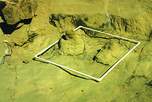 |
| The two bone fragments found by magnetometry. Harold Bowen and Rod Hardee located these fragments with the magnetometer. Both fragments come from the distal part of the tail, which had mostly eroded away. The two fragments have been exposed around their margins, where we looked (in vain) for more buried bone. The square is one meter on edge. |
Those two flags marked two very small bone fragments--each no bigger than a plum--probably from the original tail bones. We found no more bone of the tail from its middle position rearward. Incredibly, Harold and Rod had identified the positions of these two fragments with precision. If Harold were fishing, he wouldn't have needed bait; he could have snuck up on the fish and grabbed it bare handed. Underground truth.
We cannot be sure, of course, whether Harold and Rod were just lucky in placing their flags and coincidentally reaching high counts at those points. Beginner's luck, so to speak. Unfortunately, the only real test of the value of the technique for prospecting bone must be truly experimental, with controlled variables. Magnetometry holds considerable promise as a paleontological tool of the future, but as of this writing, it must be considered experimental.
When Harold retired and moved to Florida to pursue his dream of finding sunken galleons, Los Alamos physicist Phil Vergamini continued the magnetometry tests in the quarry. He came with improved equipment and produced evidence of weak anomalies, but his predictions of bones never panned out because, unfortunately, his readings were made where we predicted bones but did not find any in the excavation. He was searching in barren rock.
Radar and magnetometry devices were not the only detection tools brought to the site. Another team decided to exploit the uranium concentration in the bones. Uranium occurs naturally as isotopes. U-238 and U-235 are inherently unstable. These atoms change through time by the loss and gain of atomic particles: electrons, protons, and neutrons. The changes are sequential, so that the atom that began as uranium eventually changes to another element, finally reaching stability in daughter products such as isotopes of lead and thorium. Uranium isotopes concentrate in the chemical structure of certain minerals, such as uraninite and carnotite, the principal economic sources of this valuable element.
In low concentration, uranium also occurs in ground water, sedimentary rocks, igneous rocks, and almost everywhere on the earth. The concentrations are usually so low that only high resolution laboratory instruments can detect its presence. Fossilized trees and bones often contain surprisingly high concentrations of uranium, a fact that rock hounds use in prospecting for petrified logs. Petrified logs and dinosaur bones are both big enough to offer the possibility of sufficient uranium for detection. Indeed, during the early rush for uranium during World War II, petrified logs, and occasionally large dinosaur bones, were a principal source for this precious strategic element.
According to stories I have heard but have never seen documented, the dinosaur bones of the Morrison Formation were the early source for uranium at sites and eventually in mines throughout the West--especially in Utah, Colorado, and New Mexico. Suggestively, a uranium prospect site occurs on the jeep trail leading to the Seismosaurus site. Quite likely, Geiger counter readings indicated a high at that point, perhaps from a bone. There and elsewhere the bones are often much more enriched than the surrounding rocks, making mining difficult unless the bones are highly concentrated. Fortunately for paleontology, this is a rare situation.
The occurrence of uranium in dinosaur bones in the American West seemed incidental from the academic perspective of paleontologists. No one had ever taken a direct interest in unraveling the nature of the chemical history that produces such astonishing concentrations: in some dinosaur bone, the uranium content is 10,000 or even 100,000 times richer than in surrounding rock. Quite obviously, something happens after burial of a skeleton that promotes the uptake of uranium from the ground. Bones of living animals do not contain the minerals uraninite or carnotite, so the uranium atom must be involved in some chemical reaction that binds it to the buried bone.
Even after the uranium becomes locked into the fossil bone, or onto its surface, the isotope continues to disintegrate. As a product of the decay, extremely short wavelength electromagnetic radiation (called "gamma ray emission" or "ionizing radiation") is discharged. Gamma rays are a form of electromagnetic radiation with great penetrating power; they have a frequency greater than X rays. Gamma rays generated within the ground can pass into the air, or into surrounding rock where their energy may be absorbed. Under the right conditions, gamma rays in significant abundance might indicate the presence of something underground with a high concentration of unstable isotopes.
 |
| Portable scintillation counter. The device is measuring radiation in a core that has been drilled and removed from the bedrock. |
High-energy gamma rays can ionize other atoms; that is, they can knock electrons out, creating ions. The appropriate instrument for measuring the ionizing radiation of gamma rays is a scintillation counter--which is an apt description of the bursts of energy detected by this instrument. Most scintillation counters are installed in laboratories where samples are brought for analysis. Some, however, are portable: the instrument can be taken to the sample. Naturally, Los Alamos geologists had such equipment for field investigations, and quite naturally as well, many of the Los Alamos scientists took great interest in the uranium in Sam's bones.
Laboratory trials with several scintillation counters on samples of Sam's bone confirmed that gamma rays were detectable, and that the surrounding sandstone emitted practically no radiation. With these test results, we concluded that scintillation counting should detect buried bone at the Seismosaurus site. This straightforward conclusion, drawn from straightforward tests on samples of bone and rock, seemed encouraging.
In the field the scintillation counter would work something like Hollywood's depiction of a Geiger counter: search and search, scan the surface of the ground, until the counter "sings" or the dial indicator goes to the red line. Shout Eureka! and stake a claim: we've struck it rich with uranium.
Los Alamos scientist Bill Johnson came to the site to try a "germanium high-resolution gamma ray detector"--a high technology version of a scintillation counter. This battery-powered instrument weighed only a couple of pounds. Switch it on, adjust some dials, and take scintillation readings at grid line intersections. The result: no discernible "highs" that might indicate concentrations of radioactive materials beneath the surface.
What did these unremarkable readings mean? Perhaps they meant there was no more bone on site. Or, perhaps the instrument was not functioning properly. Or, maybe the bones were too far away from the surface of the ground, attenuating the gamma ray energy so that the scintillation counter would not pick up the radiation.
Bill tested the counter with some bone fragments still in place. It worked properly, producing the expected readings. One conclusion was unavoidable: because the scintillation counting produced no significant concentrations of radioactivity, the results could not be used for comparison with either the radar data or magnetometer data.
At this point, Bill and colleagues redesigned the experiment. They assumed that the encasing rock absorbs the gamma rays from the bones, producing a halo of radiation, with decreasing intensity outward. At some distance from the bone (the source of the radiation), the intensity would be so low that the radiation would no longer be separable from the background radiation. That distance must be less than eight feet because from the top of the mesa the first set of readings did not locate any radiation highs.
However, now a better question could be formulated: through how much rock must the gamma rays pass before they would be absorbed and therefore not recognizable on a scintillation counter positioned at a greater distance? A matter of inches, or feet? Furthermore, we recognized that perhaps not all of the bone would have the same radiation levels as the ones we had measured; some bone might have much more, some much less.
To conduct this test, the scintillation counters would be suspended from the top of the mesa down vertical holes that had already been drilled for another purpose. Measurements would be taken at prescribed intervals. At depths between eight and ten feet, if the holes were close to bones, gamma radiation should be strong enough to register on the "down-hole" scintillation counter.
Variations on this promising application continued through the 1992 field season. Other dinosaur sites in the Ojito Wilderness Study Area have considerably stronger gamma radiation. For skeletons that lead into gentle slopes where the unexposed bones are shallow, the chances are high indeed that the full extent of the skeletons might be detectable by gamma ray detection prior to excavation. To date, however, this extension of the experiments has not been conducted.
 |
| Long-period scintillation counter mounted on a tripod. By allowing the counter to record one position for fifteen minutes or even a half hour, sensitivity is enhanced. |
 |
| Reducing the scatter of background radiation. Background radiation made interpretation of scintillation tests difficult. The Los Alamos team therefore tried shielding the surface being measured with a stack of protective lead bricks. Moving the bricks proved to be back-breaking work, reducing enthusiasm for this refinement. |
Meanwhile, a fourth and final test of technological prospecting was getting underway. Through Roland Hagan, scientists at Oak Ridge National Laboratory in Tennessee learned about the experiments in new technologies for paleontology that were underway in New Mexico. Mechanical engineer Alan Witten talked to Roland by phone, then to me. Alan had an idea, and he needed to know the density of the sandstone, the density of the bones, their projected positions beneath the mesa. He focused on the three-dimensional geometry of the skeleton in the subsurface and the geometric configuration of the sandstone that encased the bones.
Alan's idea was to prospect for bones using "acoustic diffraction tomography." This would require vertical bore holes placed at strategic positions, drilled to a depth of at least twice the projected depth of the bones, and deeper if possible. The other techniques did not disturb the ground, but Alan's would be intrusive.
Acoustic diffraction tomography takes advantage of the differential rates of sound waves traveling through various kinds and layers of rock in the subsurface. Each rock type, according to mineral composition and density, transmits sound waves at a characteristic velocity. Substantial differences in density--for example, the difference between low density (slow velocity) sandstone and high density (high velocity) fossil bone--can be detected by the highly sensitive microphones used in this technology. The bones are dense because of the in-filling of minerals in their cavities and pore spaces subsequent to death and burial.
Alan brought in collaborators: Chris King, a research physicist and a major in the U.S. Army, and Joe Sypniewski, then a research contractor at Oak Ridge and now a professor at Wayne State University. Together they formed the nucleus of what Alan and friends at Oak Ridge called "The Seismosaurus Tour." They even had team T-shirts specially designed.
Alan's plans required transport of the equipment by van from Tennessee. But first, core holes had to be drilled and encased with PVC pipe that was capped and sealed at its lower end. Roland offered to help find a way to get the holes drilled using Los Alamos resources.
We decided to drill the holes directly over the positions where radar data and magnetometry records both indicated possible "targets" in the subsurface, our euphemism for Sam's bones. Unfortunately, only a couple of grid positions had favorable readings from both radar and magnetometry tests. One difficulty was the somewhat erratic records on the grid map, a consequence of the irregular ground surface. We discovered that a planed and flat surface would have been better for record-keeping and for returning to particular points in the grid with precision. The several grid maps did not exactly coincide, which in turn created problems in comparing the data. Nevertheless, we collectively agreed to about a dozen potential positions where we might reasonably expect to encounter bone at depth.
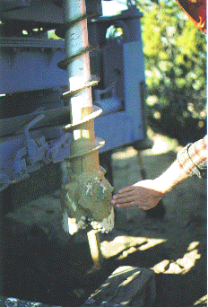 |
| Producing a core. The coring rig and drill bit provided by Los Alamos National Laboratory cut a hole seven inches in diameter but produced a continuous internal core with a two-inch diameter. |
A Los Alamos crew arrived with a truck-mounted, solid-coring drill. They maneuvered the truck over the position we rated as the best prospect. We did not expect to encounter bone at this first position to the side of the excavation perimeter. It was deliberately selected for its situation beyond the expected limits of the bone, as Alan Witten's experiment was designed to detect bone near, but not necessarily in, the bore hole. After all, if we struck bone while boring, there would be no need to use a special sensing device to know that it is there.
The drill had a hollow center. It drilled a hole seven inches in diameter, and in so doing it produced in its center a continuous two-inch diameter core for sampling. As Don Vanetten and crew brought core sections to the ground and laid them end to end on a tarp, we inspected the rock for any sign of bone. We did this first visually, searching for chips of bone or bone fragments, then with another scintillation counter, hoping at least to sense radiation from rock taken near Sam's bones. To nobody's surprise, we did not strike bone.
The drilling crew got to a depth of twenty feet. Even before we got the first hole lined with PVC pipe, in preparation for Alan's experiment with acoustic diffraction tomography, Bill Johnson took the opportunity to test for scintillation once again. He brought a different scintillation counter, a gallium arsenide detector, to the site this time. He took long-period counts (fifteen minutes at each position) at each meter of depth. For the first hole, where we expected no bone, we also expected no high readings in Bill's measurements. And that's what he got: uniformly low radiation levels all the way down, through the expected bone level at eight feet and to the bottom of the hole at twenty feet.
 |
| Hilde Schwartz and the author inspecting a core in hopes of identifying bone from a depth of twelve feet. |
The second hole was drilled where we expected to strike or be very close to bone. The coring equipment stalled at a level just beneath the projected bone level because of an impenetrable sandstone layer at that depth. When we examined the core (both visually and by scintillation) our spirits flagged. We hoped Bill Johnson might, however, find a speck of hope with the down-hole scintillation counter. But time ran out on that Sunday. Los Alamos scientists and their equipment had to return to Los Alamos and report for work on Monday morning.
Bill did not take measurements in the second hole. We even decided not to place a PVC pipe in the hole for later experiments, mainly because it was too shallow to be useful, although it did penetrate slightly beneath the projected level of the bones. Later, the hole filled in with debris.
We eventually drilled six more holes, for a total of eight--fewer than we had hoped but enough to proceed with the Oak Ridge experiments. We tested each with a scintillation detector--first on the core, then down-hole. Our spirits sank. No bone, no high scintillation counts. We each inwardly concluded that this underground truth actually falsified the predictions for more bone that we had drawn from the radar and magnetometer experiments. We left the site particularly discouraged. Nevertheless, we had the holes ready for their real purpose: for the acoustic diffraction tomography experiment to be conducted by the Oak Ridge team. Alan, however, wanted more holes, and deeper ones, but the six we drilled, each averaging about twenty-two feet in depth, would have to suffice.
Alan Witten, Chris King, and Joe Sypniewski packed their gear in an Oak Ridge van and drove from Tennessee to New Mexico, laden with computers, wires, manuals, video screens, sensing devices, and sundry electronic gear. By air freight they shipped the shotgun, an 8-gauge magnum mounted on wheels. It would shoot directly downward--point-blank range, we hoped, for "hitting" Sam--and its slug would deliver an impact from which reverberations could be measured at each of the six holes.
By the time the Oak Ridge team arrived we had exhausted all the remote sensing possibilities using the radar technology, magnetometry, scintillation counting, and even bone-witching tools. Few among us expected Alan to produce results any more convincing than we had seen from the other experiments. The others had begun their experiments with the boost of our own enthusiasm. Alan would have to generate his own. Alan's search would be the last detection technique tried on this site before the full excavation got under way.
 |
| The "Betsy" in action. Peggy Bechtel pulled the trigger on the shotgun for this particular test of acoustic diffraction tomography. The 8-gauge shotgun propels a lead slug into the ground, creating a dramatic point source for generating a shock wave that is recorded by the down-hole hydrophones. |
The shotgun was actually a commercially produced device for sending shock waves into the ground, usually for seismic experiments. Seismologists call it a "Betsy." Alan's technique thus resembled the seismic profiling that oil exploration teams regularly use in their search for underground traps for hydrocarbons. Both use seismic shock waves, Alan producing his with a Betsy, the oil exploration teams with huge truck-mounted impact hammers called "thumpers." The acoustic shock waves, or sound waves, pass through the ground at velocities affected by the composition of the rock layers: the greater the density of the rock the higher the velocity; the lower the density, the lower the velocity.
Theoretically, because the dinosaur bones are denser than the surrounding rock, sound waves that pass through the bones should accelerate briefly, then decelerate upon reentering the surrounding sandstone. Through equal distances of rock, acoustic waves that pass through bone should therefore arrive earlier. Variations in rock density, moisture, fault lines, roots, and untold other variables can alter the ideal transmission of acoustic waves in the ground. These variables were all present at the Ojito site, and all data had to be viewed with these nuisances in mind.
The Oak Ridge team, led by Alan, came to the site well prepared to gather acoustic data. Their Seismosaurus Tour T-shirts put us in better humor, but our pessimism was, by that time, deeply rooted. They set to work with enthusiasm, and we helped wherever we could.
To record the acoustic waves, Alan and crew reeled out a tube of wires and hydrophones. It was designed to hold a series of evenly spaced hydrophones to record sound waves at depth intervals within the twenty-foot holes. The six holes had been lined by PVC pipe and were now filled with water. The tube that contained the hydrophones was, in turn, filled with a special oil, so that the detectors would function properly in a fluid medium. Sound waves would pass from the ground through the PVC pipe, into water, then into the tube with oil, finally reaching the hydrophones which would record the time of arrival and the intensity of the vibrations.
 |
| A core hole ready for acoustic diffraction tomography. The hole has been lined with PVC pipe sealed at the bottom and then filled with water. The plastic tube lowered into the hole contains a series of hydrophones, which are sensors designed to receive and record shock waves in a fluid medium. The tube itself is filled with oil. The shovel is a prop to hold the tube in position. The core hole was drilled with equipment and personnel from Los Alamos National Laboratory; the acoustic diffraction tomography equipment was provided by Oak Ridge National Laboratory under the leadership of Alan Witten. Such cooperation between individuals and institutions was common throughout the excavation. |
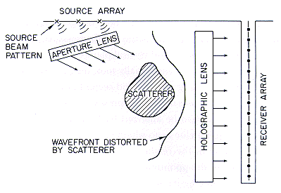
This vertical series of hydrophones is the principal receiving device for the acoustic signals. Each hydrophone is connected by wires to electrical instruments that control the signals, and these in turn are connected to a central processing computer which receives and stores all the data for subsequent analysis. The hydrophones actually function like a hologram. With application of hologram mathematics in which the vertical orientation of the hydrophones acts as a vertical plane (hence the frequently used name for this technique, acoustic diffraction tomography), the time of arrival of the sound waves at each hydrophone can be used to calculate the position and depth of a buried object, such as bone, that rests in the plane of propagation and reception at the hydrophones.
 |
| Close-up of the oil-filled tube containing the hydrophones and electronic wiring. |
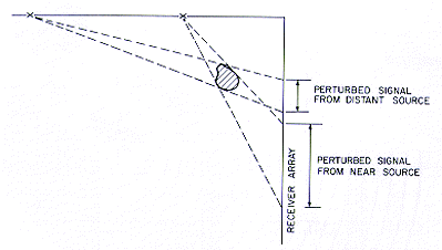
Resolution of hidden objects underground depends on accurate measurements of reception times (to thousandths of a second and less) at the hydrophones. The "shadow" of a buried object that appears on a printout indicates its presence in a single plane and from a single acoustic source. For an acoustic source in a different position, a different shadow will appear for the same object. Where the two shadows intersect, we can estimate the depth and position of the buried object. The dimensions of the overlapping areas of the two shadows give the crude dimensions in horizontal and vertical planes.
The Seismosaurus Tour initially took measurements from several holes, including the first and second holes. Their data was all digital; there was no visual representation of it on screen or on paper. It had to be analyzed back home in Tennessee. Even Alan hadn't a clue as to whether he was picking up anything interesting in the readings. There would be no instant gratification--or disappointment--for those of us on-site.
A few days later, I got a phone call from Oak Ridge with the results. Alan believed he had good news: he reported several targets, places in the subsurface where interference patterns indicated we could find bone. These targets were at the expected depth, and roughly in positions where we might expect bones: ten feet down and forty feet from the edge of the mesa where bones (the eight tail vertebrae) were last seen.
 |
| Schematic of acoustic diffraction tomography in operation. The sound source, here a hammer on an aluminum plate, generates a point-source sound wave that propagates uniformly in all directions except where changes in the subsurface cause the acoustic waves to accelerate. Hydrophones in the drilled hole detect the instant of arrival of the sound waves. By computer analysis of recorded results, we can determine whether something in the subsurface (bone, we hope) caused an acceleration, leading to anomalously fast travel time for positions in which the sound wave passed through the object. |
One of the targets was especially pronounced. Upon excavation it would prove to be the position of Sam's dorsal (rib-bearing) vertebrae. Some of the other targets would prove not to be bone, but we at least correctly established the position of the vertebral column at one point in the skeleton.
 |
| Technical interpretation of the operation of the acoustic diffraction tomography. From point sources, sound waves pass through the ground and buried objects (scatterers). If the scatterer is in the line of travel leading to the hydrophones, it may be recognized because of the early arrival times of the sound waves that passed through it. |
Testing Alan's predictions took two years, as the excavation proceeded inward from the edge of the mesa, following the line of the skeleton. The region where he predicted bone in the subsurface proved to be the set of vertebrae between the sacrum and the neck--the vertebrae that bear ribs and thus supported the stomach and other visceral organs. Using the results garnered from the excavations, we predicted the positions of bones that we should uncover later in the excavation based on data Alan generated in later visits. Alas, these predictions proved mostly incorrect. Perhaps those false targets were water-saturated zones of rock or subsurface fault lines; they were definitely not bones.
 |
| Sam's bones sensed by acoustic diffraction tomography. Excavation later demonstrated that this suggestion of hidden objects did, in fact, indicate Sam's bones. The intersection of the "shadows" mark the position and depth of something in the subsurface that caused sound waves to accelerate. The depth and approximate size of the buried object that was calculated from this data also proved to be fairly accurate. |
After learning the underground truth of excavation, I came to consider the experiment in acoustic diffraction tomography to have been moderately successful. One target, the strongest and therefore the most likely to be genuine bone, was indeed bone; the others were not, but they were not as strong. This modest success demonstrates that the technique may be useful elsewhere; applications for archaeological excavations are even more promising. Alan and the rest of the Seismosaurus Tour were encouraged enough by the experiment to publish a paper in the journal Geophysics . "Geophysical Diffraction Tomography at a Dinosaur Site" appeared in 1992.
Alan and his associates have lately miniaturized the equipment and improved the computer technology, making it more sensitive and more portable. And Alan has recently used his equipment at archaeological sites, where he has successfully located underground structures and tunnels with considerable accuracy. His miniaturized equipment is fully mobile and sufficiently sensitive so that the Betsy (shotgun) has been replaced with a more manageable--but less spectacular to bystanders--hammer and aluminum plate for generating shock waves. Variations on the surface-to-hole approach described here include hole-to-hole tomography, and tomography using radar waves generated by a ground-penetrating radar antenna.
The Oak Ridge experiments brought to a close the first round of testing of ground-based remote sensing technology. As I said, I regarded the seismic technique as having been moderately successful in the excavation of Sam--and with great potential for future success on other sites. But what of the other three technologies tested?
Remember the second drill hole, where we expected to find bone and did not? We had positioned that second hole precisely where the first experiments in radar and magnetometry together indicated we should find bone in the subsurface, ten feet beneath the top of the mesa. After the remote sensing experiments that used the holes were completed, we filled in that hole and practically forgot about it.
We shouldn't have. There was, in fact, bone there. But that story will come with the next chapter. For now, the point is simply that the radar and the magnetometer had proved somewhat successful, too. The experiments in scintillation counting did not locate bone, but ongoing applications of this technique still hold promise. However, it appears that scintillation counting does not pick up gamma ray emissions from sources deeper than a few inches from the surface. If future experiments show this conclusion to be true, the potential utility of this technique will be limited.
Additional trials of each technique and subsequent variations were conducted on-site over the course of the excavation. Unfortunately, Sam's skeleton was not complete, so that much of the testing on the mesa top was over barren rock, like Phil Vergamini's application of magnetometry. In my view, all of these technologies hold great promise for ushering in a new age of high-tech paleontology. They deserve serious attention and testing in the course of excavations at other sites. Applications beyond the realm of paleontology are manifold. For example, these technologies can be used to locate such diverse materials as concealed hazardous wastes, buried buildings, and archaeological ruins.
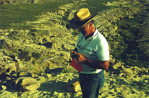 |
| Low-tech sensing. Roland Hagan with his bone-witching instrument (a coat-hanger). |
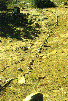 |
| A dowser's prediction. Prior to excavation, one dowser laid out a line of rocks that allegedly marked the position of Sam's neck and head-and even the eye (shown as the isolated pebble in the middle of the head). This area of the mesa was not excavated; however, isolated neck vertebrae found more than a hundred feet away tend to discredit this low-tech prediction. |
From this modest beginning, the quest for buried dinosaur bones using ground-based remote sensing devices will surely continue. Other paleontologists have identified areas where they would like to search for buried mammoth skeletons in bogs, and several National Parks have expressed interest in the technology as a means of limiting surface disturbances at paleontological excavations. Other applications will be developed from these techniques, too, especially in archaeology and related fields. But best of all, I am pleased that we have contributed to the technology being developed to monitor land fills where hazardous materials require surveillance and sometimes intervention.
There is one final story that came out of the pre-excavation phase of our attempts at remote sensing. When Alan Witten and colleagues used acoustic diffraction tomography to look for Sam, they were, in effect, "going seismic." The name Seismosaurus took on a double meaning. My original allusion to seismicity arose from what I imagined would have been the effect of Sam taking a stroll: the ground would shake with every step of this gigantic beast. Now, the Seismosaurus Project could also be easily remembered as the first dinosaur excavation project that had used seismic and other kinds of hi-tech paleontology.