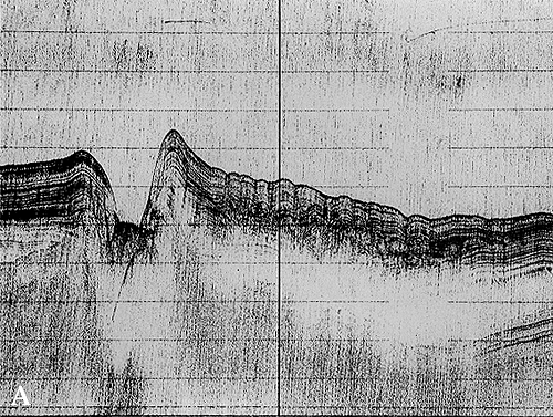
Erosional channel (A) and channel fill (B) in Recent sediments
Plate 13
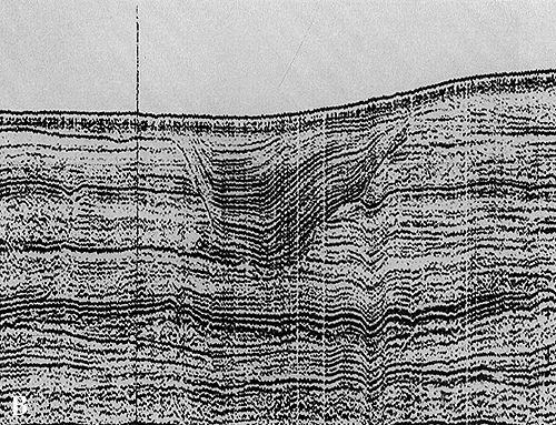
Erosional channel (A) and channel fill (B) in Recent sediments
Plate 13
These seismic sections show natural channels. One is still active (A), the other abandoned and filled by sediment (B).
The active channel is the submarine prolongation of the Crati River (Calabria, southern Italy) into the Gulf of Taranto, Ionian Sea. One may argue that this is the final reach of the river, submerged by the sea level rise that followed the melting of glaciers of the last glacial epoch. It occurs, however, at a depth greater than the rise in sea level (110-130 m); therefore, the channel was under water even during the glaciation and the low stand of sea level. Consequently, some submarine process is responsible for its excavation. The turbidity current has the proper requirements: when it gathers way and accelerates, it can acquire the power to erode the bottom. Like the discharges of river floods, the volume of turbidity currents may be quite variable. In more normal cases, the flow is confined within the channel but, sometimes, it is too voluminous and spills over. The part that flows out, with its sediment in suspension, decelerates because of expansion and lays down part of its load near the channel banks. Subaqueous levees are thus built up; they are wedge-shaped bodies that peter out away from the channel (see right-hand side of section). The growth of levees enlarges the channel section and increases its capacity; it can be asymmetrical, in which case the overspill preferentially occurs on the side where the levee is higher. This happens because of a deviation affecting all moving fluid bodies in a rotating planet (toward the right in the northern hemisphere). The deviation is known as the Coriolis effect.
The greater accumulation of sediment on one side of the channel can promote an instability of the levee slope, as illustrated here by deformed bedding; this is favored by the fine texture and high water content of levee deposits. The wrinkles you see in reflectors are produced by creeping or sliding of sediment; deeper reflectors are almost chaotic and then disappear (see white lens) indicating a strong absorption of acoustic energy sent in the subbottom (by a 3.5 kHz profiler).
In plate 13 B, acoustic waves show a deeper penetration (a different source is used, a 1 kJ Sparker): more reflectors appear, and well defined. Many are parallel and form the substratum of a distinct erosional channel filled by concave-up, onlapping strata (remember the vertical scale exaggeration causing distortion of shapes and angles). A levee is partly recognizable on the right hand side by inclined, downlapping reflectors. The dark surficial drape is made of marine sediment, which transgressed an alluvial succession. This part of the Adriatic Sea was a prolongation of the Po Plain alluvial system when the sea level was lower, i.e., during the last Ice Age.
Other channel fill and levee deposits are buried in this late Pleistocene sequence: an example is the lenticular body in the lower left of the section.
| Photos: Institute for Marine Geology, C.N.R., 1980, 1987. |
The scale is lacking; as a reference, the channel in A is about 8 m deep, the channel fill in B is almost 15 m thick.