Inclined bedding: problems of interpretation
Plate 17
Inclined bedding: problems of interpretation
Plate 17
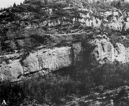
The tabular body standing out in the center of plate 17 A is about 20 m thick and composed of conglomerate (darker bands) and sandstone. It belongs to the same formation as the one seen in plate 15. The diagonal bedding indicates lateral accretion above an erosional surface cutting into marine mudstones. Medium-scale sedimentary structures (not visible) point to paleocurrent directions scattered within a wide angle, and are not conclusive for defining the main transport vector. The interpretation is thus open to both accretion models already discussed: a prograding coastal body (delta, beach) or a point bar in a shifting channel.
In actualistic terms, the basal erosion is best explained by a migrating channel. When looking at stratigraphy, however, one must take into account geologic time, particularly the time "hidden" by discontinuities such as an erosional surface. For example, deltas usually grow during high stands of sea level, with a submerged part made of marine sediments. If sea level rises rapidly, submerging a subaerial surface eroded during a previous regression, it is possible that the delta encroaches directly on this surface, because there is no time for deposition during the transgression (or the sediment supply is strongly reduced). The supposed deltaic body would have been of the coarse type, called fan delta; in practice, an alluvial fan growing into a body of water. Such an apparatus has a small size and is composed of coarse materials because it is fed by a torrential stream cutting steep relieves. A fan delta displaying the "triad" topset-foreset-bottomset beds is also known as a Gilbert type delta. Its type model derives from Pleistocene deposits of Lake Bonneville in the United States.
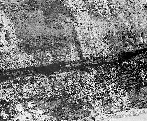
Plate 17 B shows the uppermost part of a tabular body like that in A. The contact with the overlying sandstone body is erosional and underlined by a "pavement" of pebbles. The diagonal bedding is made evident by alternations of interfingering conglomerates and sandstones (conglomerate beds close to the left, sandstone beds to the right).
Pliocene Intra-apenninic Basin, Livergnano, northern Apennines.
This plate offers a chance for some methodological remarks. As said earlier, simpler and more "parsimonious" explanations are preferred in science. What is convenient for our brain, however, is not necessarily true; it should be considered as a first step in a series of successive approximations. In sedimentology, models of facies and sedimentary bodies are built on some simplifying assumptions: that the supply of sediment is uniform and regular, that subsidence also occurs at a constant rate, and that sea level remains stationary. If, on this ground, we geologists obtain a reasonable and consistent picture, we are satisfied. If not, we try to transform constants into variables, one at a time, and see what happens to our model. During the whole history of our planet, the position of sea level changed many times, with variable frequency. As we lack absolute baselines, what we detect are relative changes of sea level, which leave their mark in sediments and in discontinuity surfaces. Some changes affect local areas or regions only, others are global: global changes are called eustatic, independently of their cause. Different factors, working at different time and space scales, can cause changes of sea level: for example, subsidence of a basin is a local factor; variation of ocean shape or volume is a global phenomenon induced by plate tectonics; the waxing and waning of glaciers reflects climatic forcing and is also global in scope.
The result of relative sea level changes are shifts of the shoreline across the continental margins. A transgressive pulsation means that the sea invades the land, a regressive one that the coastline advances seaward and enlarges the land area. These opposite trends alternate in time and give rise to transgressive-regressive cycles . Both during transgressions and regressions, when sea level is unstable, erosion can prevail on deposition. In the first case, the erosional agent is the sea (through waves and storms); in the second case, subaerial agents like rivers, glaciers and wind are responsible. More or less extensive erosion surfaces can thus be formed.
After a rise or a fall, sea level stabilizes for a while; there are high-stand and low-stand conditions, respectively. During high stands, more space is available for accommodating sediment, especially on continental shelves and epicontinental seas (those invading the interior of continents). During low stands, this space is reduced and erosion favored. As a consequence, the progradation of a delta on a shelf is possible during a relative high stand.
The coarse-grained body of 17 A was deposited in a coastal environment, and could fit both the model of a prograding delta (in which case, the term foreset bedding is appropriate) and that of a laterally shifting fluvio-deltaic channel (epsilon bedding). If one is uncertain about the interpretation, the descriptive term diagonal bedding can be used.