Parallel beds: draping
Plate 2
Parallel beds: draping
Plate 2
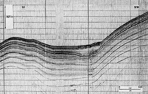
This seismic section was recorded by a device called subbottom Profiler working with waves pulsed at a frequency of 3.5 kHz. It shows the subbottom (strata underlying the sea bottom) of the Gulf of Taranto in the Mediterranean Sea. The strata are here manifested as reflectors outlined by differential reflectivity of their surfaces; in other words, acoustic waves sent from above by a ship are reflected and more or less absorbed according to contrasts in physical properties (particularly density and elasticity) between beds of the sedimentary pile. All the reflectors shown here are depositional surfaces (there is no evidence of erosion).
The style of stratification is similar to that seen in plate 1 in what concerns the parallelism and lateral continuity of depositional surfaces. In contrast, bedding is not, for the most part, horizontal, as it covers sloping surfaces. Notice that the angle of slope is higher than the real one, due to the vertical exaggeration of the seismic image: you can see that the vertical scale (Fth = fathoms; 1 fathom = ca. 1.83 m) is markedly different from the horizontal one.
At the junction between horizontal reflectors at the center and inclined reflectors to the right, a "transparent" lens occurs, with undulations above and below it. If you follow the reflectors immediately underlying the lens from the flat to the sloping area, you can note that the sediment thickness decreases. This means that the lens is an extra accumulation of sediment derived from the adjacent slope, where it has left a gap in the record. The lens is not bedded because this sediment slid, broke and mixed with water. This lack of structure, or disorganized character, is thus interpreted as a gravity deposit, i.e., a submarine slide or a mass flow.
Aggradation is the predominant growth style, as in plate 1: when it occurs on a rough bottom and mantles it with a relatively uniform thickness of sediment, the more specific term is draping.
| Photo: Institute for Marine Geology, C.N.R. 1980. |