Plane-parallel bedding: marker bed
Plate 5
Plane-parallel bedding: marker bed
Plate 5
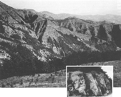
Another panoramic view of a turbidite formation, comparable with that shown in plate 1, is proposed here. This is the largest and best-exposed "flysch" body of the Apennines, the Marnoso-arenacea Formation of Miocene age. Fluvial erosion and rejuvenation (repeated uplift) of the chain made these extensive outcrops, which are observed from some shorter distance with respect to plate 1. Bedding is marked by a vertical alternation of sandstone and mudstone beds. The more resistant sandstone is protruding from cliff faces, and some individual beds can be recognized. One, in particular (see a, and inset), 5 m thick and better cemented than others, stands out; it can be easily mapped as a key bed, for the whole formation (over a distance of more than 120 km). A key, or marker bed, is used as a stratigraphic tracer for correlating distant and separated parts of the same formation or succession: as turbidites accumulate very fast, each bed marks a geologic instant, a time line.
The sandstone of this particular bed was quarried to make building and paving stones; it is cemented by calcium carbonate, and locally called "pietra serena " or "alberese. " The accompanying light band is a 7 m thick mudstone that completes the layer, deposited by a huge turbidite flow carrying more than 30 cubic kilometers of suspended particles. This was a highly catastrophic event, probably triggered by a submarine earthquake of large magnitude; a modern analog is represented by the 1929 Grand Banks turbidite in the Atlantic Ocean.
As a last observation, note that the strata are inclined; this is a secondary, or tectonic attitude because they were originally accumulated on the horizontal floor of a deep-sea plain. They were tilted around a horizontal axis that is called strike.
The two geologic formations illustrated here and in plate 1 have many features in common. First of all, they belong to the category of flysch units, bodies of detrital sediments deposited in strongly subsiding "mobile belts" of Earth crust. From these belts, narrow and elongate, and parallel to the margins of continents, mountain chains emerge on a time scale of several million or some tens of million years. Sedimentation is part of a complex sequence of geologic events, the so-called orogenic cycle, that culminates in the surrection and erosion of the mountains. During these vicissitudes, the sedimentary strata and the basins that accommodate them (they were once called geosynclines ) are deformed by folding, shearing, and faulting. The deformation is related to subduction of lithosphere beneath the continental margin or to a collision between continental masses, and causes mainly compression and shortening of the crust. However, stratified slabs of various sizes, such as those pictured in these plates, can remain relatively undisturbed and display the original stratigraphy. The slabs form tectonic units (relatively rigid slices, sheets and shingles called thrusts ) that are juxtaposed and superposed by the tectonic compression in mountain belts; surfaces of shear and friction separate them. They constitute tectonic (mechanical) boundaries, which must be distinguished from stratigraphic boundaries.
A second characteristic that is shared by the two formations is the basic sedimentary process, the turbidity current. This is not continuous, but punctuated in time as all catastrophic, or sporadic events. I introduced this mechanism to explain the lacustrine varves seen in plate 3, but the volumes of sediment involved in marine flysch basins are much larger. Thick and very thick beds, reaching volumes of 1 Km3 or more, are not uncommon; their estimated time of recurrence is in the order of thousands to tens of thousand years. Related beds and layers are often referred to as meg-abeds and megalayers, respectively. The one emphasized in plate 5 is named Contessa Bed. Single sedimentary events of such a huge size cannot be simply the result of fluvial floods or sea storms, though of large scale. A large reservoir of sediment, already accumulated somewhere, had to be available for instantaneous remobilization into deep water. The search for these "parking areas" or sediment repositories along basin margins is one of targets of sedimentological research, and a challenge for actualistic principles. Various areas have been recognized as "prone" in modern settings, but few have provided positive evidence for major events: the Mississippi delta is one of them. It has fed large turbiditic flows into the Gulf of Mexico, especially during glacial epochs, when sea level stood low and basin margins were more unstable. The pull of gravity could then induce great failures and sliding.
| Photo: G. Piacentini 1970. |