Planar, low angle lamination
Plate 40
Planar, low angle lamination
Plate 40
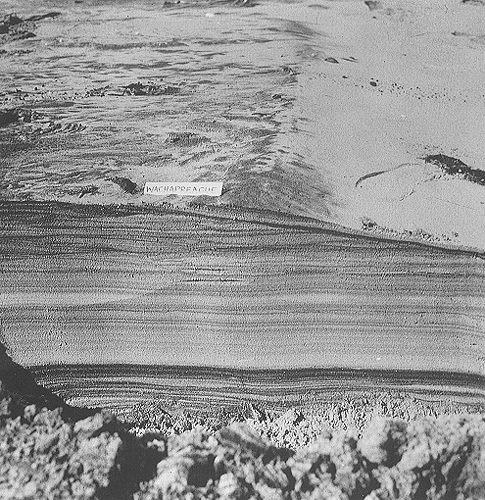
This small trench, about 35 cm deep, was dug across a beach crest (berm), separating the subaerial beach from the swash zone (to the right). Heavy minerals, rich in metals, were concentrated by the wave sieving into dark laminae; for this reason, lamination is particularly well defined, and records the vertical accretion of the sandy beach. The metallic minerals can reach economic concentrations and form sedimentary ore bodies (placers).
Most laminae form a plane-parallel, horizontally laying tabular set. In the upper portion, on the other hand, inclined surfaces and angular contacts can be seen. They indicate the presence of erosional truncations, caused by occasional or seasonal storms. During storms, the water level rises and the mark line shifts landward; at the same time, water agitation due to breaking waves increases. Sand is removed both as bed and suspension load, and is carried seaward. With the return of fair weather, the berm and the swash zone reoccupy a lower, seaward position and the sand is slowly brought back to shore along the sea bottom. Erosional surfaces are then covered by new sets of laminae.
Overall, an accreting beach will show in this part (foreshore zone) depositional features (laminasets) alternating with erosional features (truncations). Both depositional and erosional surfaces are planar and make low angles with the horizontal; they thus outline a stratification style made of intersecting wedges, which can be defined as wedge-shaped bedding, and is associated with planar, low-angle lamination.
Swash zone laminae can dip either landward or seaward, depending on whether they were deposited on one flank or the other of the littoral berm. Dip angles are, in any case, well below the critical angle of repose. The interface is, in fact, almost continuously swept by waves, which keep on it a super critical flow regime owing to the thinning water cover; on the backward side of the berm, however, wave energy is rapidly dissipated as water infiltrates through the sand, and a relatively steeper angle can be reached. Coarse sediment particles, shells, flotsam and jetsam are abandoned there, especially in storm berms.
At the toe of the swash zone, where the incoming waves and the backwash collide and water depth increases, the hydraulic regime becomes sub critical and ripples appear on the sand (plate 31).
| Photo: A. Bosellini 1992. |