|
 Rural
Beginnings Rural
Beginnings
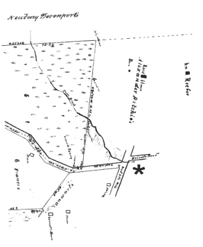
Through the 19th century, the area including and adjoining today's
Fifth Avenue neighborhood was known as Petersville. The northwest
corner of the neighborhood appeared on an 1846 "Map of a Farm
Belonging to John R. Peters Situated in the Town of New Rochelle,"
at left. Today's Portman Road, which forms the western boundary
of the study area, was labeled as "Road to the Mill";
the street was known as Mill Road at least until 1931, although
the size, age, location, and purpose of the mill it refers to do
not appear to have been documented. Pine Brook passed under the
intersection of Portman and what is today Fifth Avenue, which, in
1846, was labeled, east of the intersection, as a private road.
The land that is now City Park was labeled as the property of Alexander
Ritchie, and the site of his house and barn. The intersection of
what is today Portman Road and Fifth Avenue is indicated by the
asterisk.
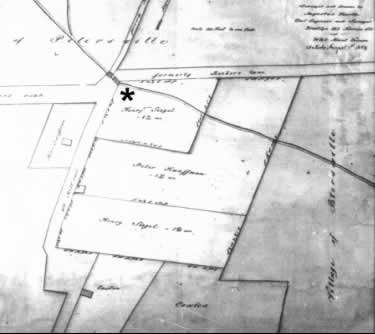 In
1855, much of the study area's western portion was in the hands
of Peter Kauffman and Henry Siegel. On an 1855 map, today's Fifth
Avenue was labeled as "Formerly Reebers Lane," and Pine
Brook passed underneath two bridges at the intersection with "Old
Mill Road." The lands east, north, and west of Kauffman's and
Siegel's holdings were labeled as "Village of Petersville."
Today's Fifth Avenue west of the study area was called Peters Road.
The asterisk at right indicates the same location as on the 1846
map. In
1855, much of the study area's western portion was in the hands
of Peter Kauffman and Henry Siegel. On an 1855 map, today's Fifth
Avenue was labeled as "Formerly Reebers Lane," and Pine
Brook passed underneath two bridges at the intersection with "Old
Mill Road." The lands east, north, and west of Kauffman's and
Siegel's holdings were labeled as "Village of Petersville."
Today's Fifth Avenue west of the study area was called Peters Road.
The asterisk at right indicates the same location as on the 1846
map.
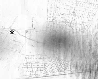
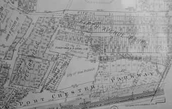
In 1856, today's City
Park property was still owned by Alexander Ritchie. The lands east
of Ritchie's property and between the study area and the main line
of the New York and New Haven Railroad had been subdivided. The
railroad, which was completed through New Rochelle in 1848, is seen
as a heavy black line running across the bottom of the map. According
to the map's title, the subdivided properties belonged to an organization
called the Petersville Homestead Association. Siegel and Kauffman
retained the lands in the western portion of the study area. The
MacLeay Apartments now stand on the site of the subdivided properties
at the upper-right portion of the map. The eastern two-thirds of
the study area was labeled "Land of Lorenz Bielm," possibly
corrupted into "Biehn," the name of a street currently
located within the study area. The jagged southern boundary of Bielm's
holdings today forms the southern boundary of the study area. Fifth
Avenue was called Morris Avenue; the asterisk indicates what is
today the intersection of Fifth Avenue and Portman.
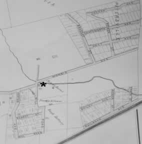
Little development took
place in the study area before the early 20th century. The 1901
Bromley map of the neighborhood, shown at right, indicates that
no building had taken place in the subdivided areas north and south
of the study area. Siegel's and Kauffman's properties had been acquired
by James Burns and Fred Krause, who had erected a few wooden buildings
and auxiliary structures on their property. Pine Brook continued
to run underneath the jagged intersection of what is today Fifth
Avenue, but was then known as Morris Avenue east of Mill Road and
Peters Road west of Mill. The Petersville name remained north of
the study area. The asterisk indicates the same location as on the
1846, 1855, and 1856 maps.
 Urbanization Urbanization
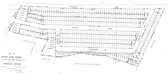
By 1907 Bielm's, Burns's, and Krause's former properties were owned
by Frederick Lorenzen. A map filed that year with the Westchester
County Registrar called the district "Fifth Avenue Park,"
possibly in anticipation of the construction of City Park across
Fifth Avenue from the neighborhood. The study area was neatly subdivided
into lots as close in size to 25-by-100 feet as was possible within
the irregular boundaries of the site. This lot size, the standard
for developers of New York City rowhouses during the 19th century,
indicates that Lorenzen envisioned the neighborhood as a dense,
urban district. Despite the new name, the map described the area
as "part of map of the Village of Petersville." Fifth
Avenue had acquired its present name, and Pine Brook had been redirected,
apparently into a pipe, which ran underneath the neighborhood and
the intersection of Mill and Fifth.
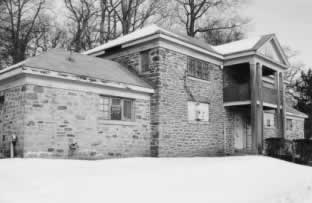 The
neighborhood underwent substantial changes around 1910. That year,
the City of New Rochelle purchased the land that was to become City
Park. According to local historian Herbert B. Nichols, writing in
1938, "The park contains nearly 30 acres, a part of which has
been left as natural woodland. The rest, with a suitable athletic
building, has been conditioned into baseball diamonds, football
fields, and a running track." The Municipal Recreation Building
described by Nichols was completed in 1923 and designed by Lawrence
M. Loeb, an architect of several Westchester County residences.
The building, visible at left, still stands, although boarded up
and unused, in City Park. The
neighborhood underwent substantial changes around 1910. That year,
the City of New Rochelle purchased the land that was to become City
Park. According to local historian Herbert B. Nichols, writing in
1938, "The park contains nearly 30 acres, a part of which has
been left as natural woodland. The rest, with a suitable athletic
building, has been conditioned into baseball diamonds, football
fields, and a running track." The Municipal Recreation Building
described by Nichols was completed in 1923 and designed by Lawrence
M. Loeb, an architect of several Westchester County residences.
The building, visible at left, still stands, although boarded up
and unused, in City Park.
Just as significantly, 1910 was the year in which the trolley was
extended to the study area. By that time, New Rochelle had developed
a sophisticated trolley system that had begun in 1885 with the organization
of the New Rochelle and Pelham Railway Company and the New Rochelle
Street Horse Railway Company. From City Park, riders could travel
down Fifth Avenue to North Avenue, where they could transfer to
the trolley that would take them downtown. A Main Street line from
Downtown traveled to Mamaroneck; a connection to Mount Vernon made
it possible to ride all the way to New York City. So popular were
the trolleys and so willing were their patrons to travel long distances
that, according to Nichols, "The trolley and its connection
with New York City had been fought by local merchants because they
feared that shoppers would take the trolley to New York instead
of shopping in New Rochelle." By the 1940s, as throughout the
country, buses had replaced many trolley lines.
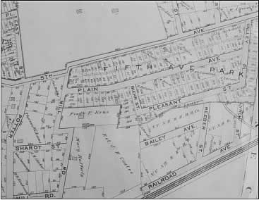 By
1910, home builders had already begun subverting Lorenzen's orderly,
dense subdivision plan. The 1910 Bromley map, at right, shows 11
wooden buildings and one wooden auxiliary structure present in the
study area, all on combined lots; 146 Pleasant, for example, is
tucked into the corner of what was originally conceived of as three
lots, and three houses on Plain Avenue share a frontage of 125 feet,
or five lots. By
1910, home builders had already begun subverting Lorenzen's orderly,
dense subdivision plan. The 1910 Bromley map, at right, shows 11
wooden buildings and one wooden auxiliary structure present in the
study area, all on combined lots; 146 Pleasant, for example, is
tucked into the corner of what was originally conceived of as three
lots, and three houses on Plain Avenue share a frontage of 125 feet,
or five lots.
The 1915 New York State
Census provided a thumbnail sketch of the neighborhood's population.
All of the neighborhood's houses were single-family dwellings, and
the male heads of household were primarily laborers or other blue-collar
workers. Fifth Avenue's residents included natives of Germany, Italy,
Russia, and Poland. Plain Avenue's residents were from Italy, Scotland,
Ireland, Germany, Sweden, and England. Pleasant Street was entirely
Italian, except for a German bookbinder, his Irish wife, and their
two American-born daughters.
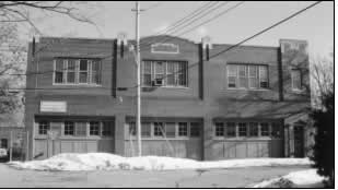 Subdivision
of area properties continued into the 1920s. In 1925, Rosina B.
Krause subdivided her land along the east side of Mill Road near
Sharot Street into 18 properties, 16 of which had 25-foot frontages.
Again, however, dense development did not follow; by 1929, five
of the lots were purchased by the Sheffield Farms Dairy, which erected
the milk distribution center shown at left. The structure, now occupied
by the New Rochelle Humane Society, included, according to the 1931
Sanborn Fire Insurance Map, an office, wagon storage, and feed storage. Subdivision
of area properties continued into the 1920s. In 1925, Rosina B.
Krause subdivided her land along the east side of Mill Road near
Sharot Street into 18 properties, 16 of which had 25-foot frontages.
Again, however, dense development did not follow; by 1929, five
of the lots were purchased by the Sheffield Farms Dairy, which erected
the milk distribution center shown at left. The structure, now occupied
by the New Rochelle Humane Society, included, according to the 1931
Sanborn Fire Insurance Map, an office, wagon storage, and feed storage.
In 1928, the study area
was not zoned as a purely residential district. Those areas that
were residential were zoned for multiple dwellings. The entire block
bounded by Fifth Avenue, Mill Road, Plain Avenue, and Valley Place
was zoned "O," or "business." The south side
of Plain was also zoned for businesses. Both sides of Pleasant Street
were zoned "C" or "multifamily residential."
The "O" zoning accommodated modifications and uses such
as those present at 71 Plain, where a store was added on to the
front of a 1914 Dutch Colonial Revival house typical of many built
throughout the neighborhood during its early years.
 By
1929, the neighborhood had considerably filled in. The 1929 Hopkins
Atlas showed several masonry buildings to have been constructed,
particularly along both sides of Pleasant Street and the south side
of Plain Avenue between Biehn and Valley. The Fifth Avenue trolley
line terminated at Fifth Avenue and Mill Road. The property between
the study area and the railroad tracks was labeled "Pelham-Port
Chester Parkway," indicating the proposed route of a highway
running from Fairfield County, Connecticut to the Bronx along the
eastern portion of Westchester County. The lands between Mill Road
and the Mamaroneck town line near the eastern portion of the study
area, which were never built upon, were acquired by Westchester
County in the early 1930s. Although the parkway was never built,
this property was used as the right-of-way for the New England Thruway
(the Westchester County portion of Interstate 95), which opened,
in its entirety, on October 15, 1958. East of City Park, where the
MacLeay Apartments were constructed in 1949, were approximately
eight buildings, all, except for one, built out of wood. By
1929, the neighborhood had considerably filled in. The 1929 Hopkins
Atlas showed several masonry buildings to have been constructed,
particularly along both sides of Pleasant Street and the south side
of Plain Avenue between Biehn and Valley. The Fifth Avenue trolley
line terminated at Fifth Avenue and Mill Road. The property between
the study area and the railroad tracks was labeled "Pelham-Port
Chester Parkway," indicating the proposed route of a highway
running from Fairfield County, Connecticut to the Bronx along the
eastern portion of Westchester County. The lands between Mill Road
and the Mamaroneck town line near the eastern portion of the study
area, which were never built upon, were acquired by Westchester
County in the early 1930s. Although the parkway was never built,
this property was used as the right-of-way for the New England Thruway
(the Westchester County portion of Interstate 95), which opened,
in its entirety, on October 15, 1958. East of City Park, where the
MacLeay Apartments were constructed in 1949, were approximately
eight buildings, all, except for one, built out of wood.
On the 1931 Sanborn
Map, the study area is shown to be primarily residential, with some
important exceptions. Fifth Avenue, similar to today, had mixed
commercial and residential uses, with dwellings interspersed with
stores, two contractors' yards, storage areas, a sheet-metal works,
and a gas station in the same location as today's Citgo station.
The north side of Plain Avenue was entirely residential, except
for a factory located near Mill Road; the south side was also entirely
residential, except for the store, previously mentioned, at 71 Plain.
Pleasant Street was entirely residential. Even so, the neighborhood
must have had a similar jumbled appearance to today's; most dwellings
had auxiliary buildings, likely chicken coops or storage sheds.
Moreover, the large number of open lots in the neighborhood, still
present, prevented the creation of a continuous residential streetscape,
except for the small residential enclaves on the south side of Pleasant
Street and the north side of Plain.
Significant change came
to the neighborhood in 1955, when it was zoned as an M-1 Light Manufacturing
District. Since then, residential and industrial uses have shared
the study area. No new houses have been built in the neighborhood
since the rezoning, which prohibits residences, and several former
houses, such as 53 Pleasant Street, have been converted to commercial
use.
Buses, which took over
New Rochelle's trolley routes beginning in the 1940s, proved to
be a mixed blessing. Although the new, air-conditioned buses initially
elicited "applause from merchants and shoppers who crowded
the curbs" to see them in Downtown New Rochelle, inconsistent
service ultimately followed, likely decreasing the Fifth Avenue
neighborhood's appeal. The Fifth Avenue bus line was extended to
Valley Place by 1973, where it looped back along Plain Avenue, but
this may have decreased the attractiveness of the neighborhood.
When bus service had been extended through a primarily African-American
neighborhood in 1967, for example, one resident called it a "Stab
in the back to Negroes," protesting to his Councilman, "Is
it because Negroes now own the properties along this route on Lincoln
Avenue and the surrounding area why you decided to give them more
air pollution with the accompanying noise and litter?"
New Rochelle's bus operators
ultimately hit hard times; but 1970, the intervention of the County
Executive was needed to prevent termination of Sunday service on
some city lines, and in 1974, service cutbacks of 15% were imposed
in some areas due to financial hardship. Today, the No. 61 route
of the Westchester County Bee-Line bus, operated by Liberty Lines,
stops at City Park approximately every half hour on weekdays on
its way to Downtown New Rochelle.
|