|
Click
here for Westchester County Quickfacts
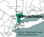
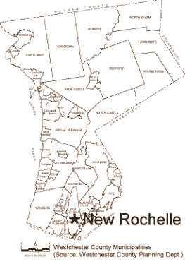
New Rochelle's location on Westchester's Long Island Sound shore
places it within one of the state's wealthiest counties. According
to 1995 estimates from the United States Census Department, Westchester
has New York's fourth-highest median income, at $53,043. Only Putnam,
Nassau, and Rockland, also New York City suburbs, and all much smaller
in size than Westchester's 443 square miles, lead it.
As shown on the map above, Westchester County borders, on its south,
the New York City borough of the Bronx. According to historian Frank
E. Sanchis, this location at New York City's door-step has "always
put it in the center of activity relative to the balance of the
nation." Indeed, Westchester's development has historically
been fueled by its proximity to what has been, since 1820, America's
largest city. Before the days of railroads or highways, Westchester
had the trade routes of the Hudson River and Long Island Sound;
later, in the 18th century, the primitive post roads to Albany and
Boston were cut through Westchester's rolling, wooded hills.
When New York City's population boomed after the 1825 completion
of the Erie Canal, Westchester furnished many of the city's raw
and finished goods. Iron foundries were located throughout the county,
and Westchester's numerous brickyards and marble quarries provided
the materials for the thousands of row houses and monumental new
institutional buildings spreading across Manhattan. When Newgate
Prison in Greenwich Village was no longer adequate, it was replaced
in 1828 by Sing Sing, "up the river" in Westchester County.
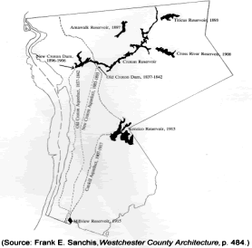
When a reliable and clean source of drinking water was needed, New
Yorkers looked to Westchester, where the Croton Dam was completed
in 1842. Today, as the map at left shows, the county is still a
vital link in the New York City water supply system, even as development
pressures have threatened water purity.
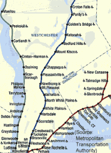
In the 1840s, the railroads
came. In 1844, the New York and Harlem Railroad reached White Plains;
the New York and Hudson River line was completed to Peekskill in
1849. That year, the New York and New Haven opened its route through
eastern Westchester. Soon thereafter, population began to shift
from the northern half of Westchester to the south, clustering around
railroad stations. All three railroads, which now originate from
Manhattan's Grand Central Terminal, are operated by the Metropolitan
Transportation Authority, and are heavily used by commuters. The
map at right shows today's routes in Westchester.
The railroads' effectiveness at stimulating development was seen
in the establishment of Mount Vernon, which is located between New
Rochelle and Yonkers and, like the other two, borders the Bronx
on its south. Unlike Yonkers or New Rochelle, which date back as
communities to the 17th century, Mount Vernon, according to Sanchis,
"was a new idea - a community of people who were economically
dependent on [New York City], and who would be traveling back and
forth every day - a commuter suburb." Together, in 1851, a
group of skilled tradesmen affiliated with "Mechanics Mutual
Protection No. 11" in New York City purchased five farms totaling
369 acres, and subdivided them according to a grid plan. The leader
of the group, John Stevens, saw the endeavor as a means of improving
the condition of New York's working class by freeing it from rent
payments and enabling it to enter the class of property owners.
Mount Vernon was incorporated as a village in 1852, and rapidly
grew to become a city 40 years later.
Between 1865 and 1920, Westchester's population boomed, multiplying
from about 100,000 to almost 350,000. During the 1920s, the county's
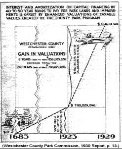
growth became channeled along the routes of its new automobile parkways,
the finest highway system in America. Following the 1925 completion
of the Bronx River Parkway, the world's first limited-access public
motor-route, Westchester built a highway system that was second
to none, much of it funded by projected increases in real estate
valuations. Development, largely consisting of single-family homes
along the parkways' edges, boomed. The Saw Mill, Hutchinson River,
and Cross County Parkways were begun during a period of intense
parkway building before World War II, and although no longer aesthetically
outstanding, they continue to funnel automobile drivers in and out
of New York City.
Linked by the new highways was an equally impressive system of golf
courses and lush county parks. Among these was New Rochelle's Glen
Island, taken over in 1925 by Westchester County, and famous in
the 1930s for the appearance of prominent big bands at its Casino;
and Playland, a model amusement park completed by Westchester County
in 1927. Playland, now on the National Register of Historic Places,
is still operated by county government. Amenities such as these
earned Westchester a reputation as the nation's most desirable suburb.
Westchester's prosperity was underscored by the decision of many
New York department stores to open branches in the county beginning
in the 1930s. B. Altman opened its White Plains store in 1934; Arnold
Constable followed, in New Rochelle, in 1937. Lord & Taylor
completed its Eastchester store in 1949, the same year that Macy's
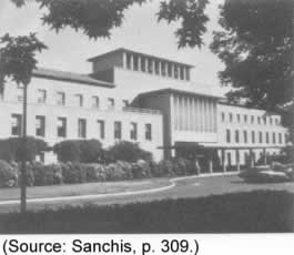
opened in White Plains. In 1953, General Foods became the first
of many corporations to leave behind its Manhattan headquarters
for a new suburban campus, in White Plains, seen at right. The section
of Westchester Avenue near White Plains, a major headquarters location,
has since become known as the "Platinum Mile."
Westchester has enjoyed the benefits of having an affluent, largely
white-collar population. Today, it remains a major center of corporate
headquarters. School drop-out rates in the county are a scant 1.5%,
and 80% to 90% of students continue their educations past high school.
Although population grew slowly from 1980 to 2000, from 866,599
to 871,894, the county is becoming more diverse. Between 1980 and
1990, the African-American population grew by 15%, and the Asian
population, by 113%.
|