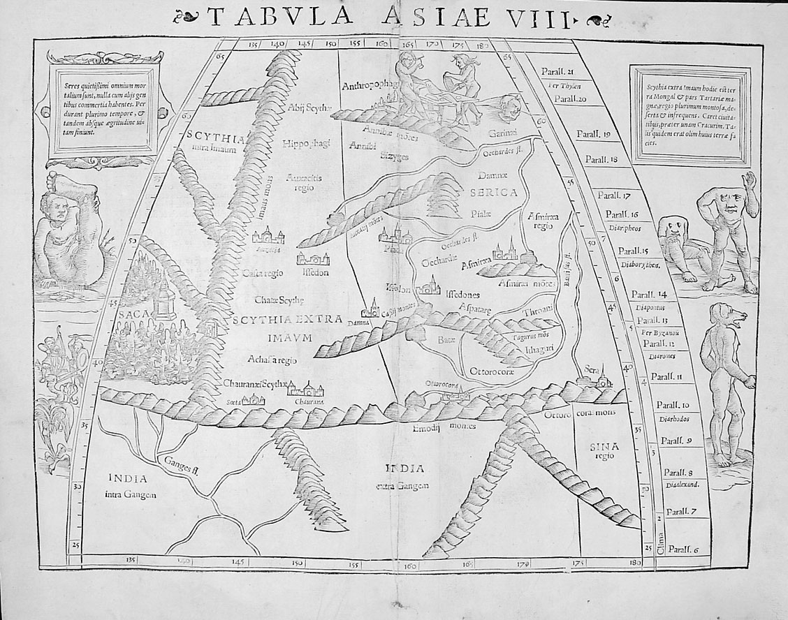
INDIA: A PTOLEMAIC VIEW, c.200
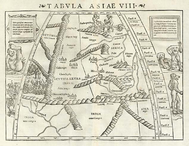
INDIA: A PTOLEMAIC VIEW, c.200
A medieval recreation of *Ptolemy's* map of Asia, including India; *a larger image of the map*
Source: http://www.henry-davis.com/MAPS/Ancient%20Web%20Pages/119J.html
(downloaded Mar. 2004)
TITLE: The world according to Ptolemy DATE: A.D. 200
AUTHOR: Claudius Ptolemy
DESCRIPTION: The early period of cartography, from 4,000 B.C. to A.D.200 culminates with the contributions of the famous Greek scholar named Claudius Ptolemy. Little is known, personally, of this pivotal man aside from the general period during which he was active ca. A.D. 90 to 168 (during the reigns of Hadrian and Antoninus Pius) and that he lived in, or near, Alexandria Egypt. During the second century, Alexandria was not only the richest city in the world, with regard to learned institutions and treasures of scholarship, but also the wealthiest commercial place on the earth. It was a place where seafaring people and caravans from all parts of the known world would use to congregate, thereby providing the opportunity to collect knowledge of far away lands and seas. In spite of such scant personal knowledge, Claudius Ptolemy's writings have had a greater influence on cartography, and on geography in general, than that of any other single figure in history.
While Ptolemy is most frequently associated with geography and cartography, he also wrote important works in a number of other fields including astronomy, astrology, music and optics. He composed a Table of Reigns, a chronological list of Assyrian, Persian, Greek, and Roman sovereigns dating from Nabonasar to Antoninus Pius, a biographical history of kingship. His Analemma was mathematical description of a sphere projected on a plane, subsequently known as an "orthographic projection," which greatly simplified the study of gnomonics. His work entitled Planisphærium [the Planisphere], described a sphere projected on the equator, the eye being at the pole, a projection later known as "stereographic". But there are two treatises for which Ptolemy is most celebrated. The first of these treatises is his Magale Syntaxis (ca. A.D. 141), a composition dealing with astronomy and mathematics, more commonly known by its hybrid Greco-Arabic title, the Almagest, in which he lays down the foundation of trigonometry and sets forth his view of the universe. Here he explains his belief that the earth is a stationary sphere, at the center of the universe, which revolves about it daily. While his proofs of the sphericity of the earth are still accepted today as valid, Ptolemy rejected the theory of the rotation of the earth about its axis as being absurd.
Ptolemy's approach to geography was strictly scientific and impersonal. He was interested in the earth, all of it, not just the habitable part, and tried to fit it into a scheme of the universe where it belonged. He was also interested in the relationships between the earth and the sun, the earth and the moon, in scientific cause and effect of climate; and above all, he was concerned with a scientifically accurate portrayal of the spherical earth in a convenient readable form. More than any one of the ancients, Claudius Ptolemy succeeded in establishing the elements and form of scientific cartography. This he did through his second great treatise, Geographike Syntaxis, called by him, "the geographical guide to the making of maps", and, in later centuries, shortened to simply Geographia, or (incorrectly) Cosmographia. This work is actually the first general atlas of the world to have survived, rather than a "Geography" with a long textual introduction to the subject of cartography. Here for the first time are documented the duties and responsibilities of the mapmaker, his limitations, and the nature of the materials he was to work with. This single treatise remained the standard work on geographical theory throughout the Middle Ages, was not superseded as such with the 16th century, and constitutes one of the fundamental tenentes of modern geodesy.
Although no original manuscript of this text has survived the ravages of time, several manuscript copies, dating from the closing centuries of the Byzantine Empire (ca. 11th century), still exist. These Byzantine copies of the Geographia are comprised of eight "Books" which Ptolemy introduces by supplying two very influential definitions - that of chorography and geography. He defines chorography as being selective and regional in approach, "even dealing with the smallest conceivable localities, such as harbors, farms, villages, river courses, and the liken. Geography, he said, differs from chorography in that it deals with "a representation in picture of the whole known world together with the phenomena which are contained therein". As he proceeds to elaborate his definition of geography, it becomes apparent that Ptolemy conceived that the primary function of geography was "mapmaking", and that, to him, geography was synonymous with cartography. "It is the prerogative of Geography," he said, "to show the known habitable earth as a unit in itself, how it is situated and what is its nature; and it deals with those features likely to be mentioned in a general description of the earth, such as larger towns and great cities, the mountain ranges and the principle rivers." No divergence from these fundamental matters should be made, except for "features worthy of special note on account of their beauty." Having thus introduced an elastic clause into an otherwise rigid geographical code Ptolemy went on to elaborate the task of the cartographer, which is to survey the world "in its just proportions," that is, to scale. Cartography is not an artistic endeavor according to the Greek Scholar, but should be concerned with the relation of distance and direction, and with the important features of the earth's surface which can be indicated by plain lines and simple notations(enough to indicate general features and fix positions).
For these and other reasons, Ptolemy knew mathematics to be an important part of cartography. "It is the great and exquisite accomplishment of mathematics to show all these things to the human intelligence." With the aid of astronomy and mathematics, Ptolemy concluded, the earth could be mapped as accurately as the heavens had been charted. In cartography, said Ptolemy, one must contemplate the shape and size of the entire earth. Its position under the heavens is extremely important, for in order to describe any given part of the world one must know under what parallel of the celestial sphere it is located. Otherwise how can one determine the length of its days and nights, the stars which are fixed ovehead, the stars which appear nightly over the horizon and the stars which never rise above the horizon at all. All such data must be considered as important to the study and mapping of the world.
The first Book of the Geographia is devoted primarily to theoretical principles, including a discussion of globe construction, the description of two map projections, and an extended, through amicable, criticism of his primary source, Marinus of Tyre, "the latest of the geographers of our time". Marinus, who flourished about A.D. 120, exerted considerable influence on the development of mapmaking. He seems to have studied and made astronomical observations in Tyre, the oldest and largest city of Phoenicia, which, even at that late date, maintained important commercial relations with remote parts of the world. This 'tutor' of Ptolemy had read nearly all of the historians before him and had corrected many of their errors (presumable errors relating to the location of places as contained in travelers' itineraries). He had, moreover, edited and revised his own geographic maps, of which at least two editions had been published before Ptolemy saw them. The final drafts were nearly free from defects and his text, which we know of only through Ptolemy, was so reliable, in Ptolemy's estimation, that "it would seem to be enough for us to describe the earth on which we dwell from his commentaries alone, without other investigations." According to Ptolemy, the most significant feature of the maps of Marinus was the growth of the habitable world and the changed attitude toward the uninhabited parts. Marinus was a good man, in Ptolemy's estimation, but he lacked the critical eye and allowed himself to be led astray in his scientific investigations. According to Ptolemy, even Marinus had made mistakes, either because he had consulted "too many conflicting volumes, all disagreeing," or because he had never completed the final revision of his map. Whichever it was, the map needed correcting - by Ptolemy, of course. However, Marinus' treatise on geography, with its maps, should still be ranked among the most important of the lost documents of the ancients, if for no other reason than that it was the foundation upon which Claudius Ptolemy built.
In another chapter in Book I, Ptolemy wrote that there are two ways of making a portrait of the world; one is to reproduce it on a sphere, and the other is to draw it on a plane surface. Each method has its advantages and disadvantages. "When the earth is delineated on a sphere, it has a shape like its own, nor is there any need of altering [it] at all." However, it is not easy to provide enough space on a globe for all of the details which should be included on it; moreover, if it is large enough to contain everything that should be drawn on it, the globe would be too large for the eye to encompass. Ptolemy then continues to give specific instructions on how to construct a globe properly.
If the second method of drawing the earth is used, that is, if the spherical earth is projected onto a plane surface, certain adjustments are obviously necessary. Marinus had given this matter considerable thought, rejecting all previously devised methods of obtaining congruity on a flat map; yet, according to Ptolemy he had finally selected the least satisfactory method of solving the problem. Marinus had laid out a grid of strait lines equidistant from one another for both his parallels of latitude and meridians of longitude. This was contrary to both truth and appearance, and the resulting map was badly distorted with respect to distance and direction, for if the eye is fixed on the center of the quadrant of the sphere which we take to be our inhabited world, it is readily seen that the meridians curve toward the North Pole and that the parallels, though they are equally spaced on the sphere, give the impression of being closer together near the poles. Ptolemy was well aware that it would be desirable to retain a semblance of spherical proportions on his flat map, but at the same time he decided to be practical about it. To avoid, or at least to lessen these errors by Marinus, Ptolemy proposed to employ what is now called a conical projection, i.e., to project the map, with equidistant parallels, on a conical surface developed around the axis of the earth, and passing through the parallels of Rhodes and Thule. When such a conical surface is extended on a plane, a network with circular parallels and rectilinear, converging meridians arise. Lest the proportions of certain parts of the mapped territory should be too much deformed, only the northern or the southern hemispheres should be laid down on the same map by this projection, which is consequently inconvenient for maps embracing the whole earth. Ptolemy only rigorously applies the conical projection to the northern part of his map of the world. To represent the known parts of the southern hemisphere on the same sheet, he describes an arc of a circle parallel to the equator, and at the same distance to the south of it, as Meroe [Mæroe ] is to the north, and then divides this arc in parts of the same number and size, as on the Parallel of Meroe. The network is then obtained by joining the intersections to corresponding points on the equator.
Ptolemy's exhaustive criticism of the imperfect methods of drawing maps adopted by Marinus, would lead to the expectation that he himself would have used some of his own recommended projections in constructing his maps. But such was not the case. Because while Ptolemy employs his conical projection in his first general world map, for the remaining twenty-six special regional maps he uses the rectangular projection of Marinus with due observance of the ratio between the longitude and latitude at the base of the map. This inconsistency seems to have astonished his publishers in the 15th and 16th centuries. With one exception (an Italian translation by Berlinghieri), every editor of Ptolemy's Geographia has published, not the original maps, but a modification of them by Nicolaus Germanus (Donis), who, with praiseworthy exactness and without any further alterations, reproduced the originals, on a projection with rectilinear, equidistant parallels and meridians converging towards the poles.
Book II of the Geographia opens with a prologue "of the particular descriptions", which is to say, the maps he was about to present, and a general statement of his mapmaking policy. There is also an introduction to data collection, evaluation, preparations for drawing, how and in what order to mark boundaries, and how to use the appended tables. Books II-VI and the first four chapters of Book VII are devoted to a complete catalogue of some 8,000 inhabited localities laid down in the twenty-six special maps of the geography. For every place-name, estuaries sources, mountains, promontories, peninsulas, etc., mentioned in the catalogue/table, latitude and longitude (in degrees) is given. It is an exception when geographical or descriptive remarks are added to this bare enumeration of names. What is remarkable and president-setting is the organization of these tables. Unlike Marinus who listed longitude on one page and latitude on another, Ptolemy began the tradition of listing the positional coordinates together and in a usable system that was practical to follow.
The latitude and longitude assigned to well-known places were fairly accurate since the traditional accounts concerning them agreed and more exacting measurements/observations had been taken; but the places that were little known, or about which there was considerable uncertainty, presented a major problem to geographers like Ptolemy. When traveling overland it is usually necessary to diverge from a straight line course in order to avoid inevitable land-barriers; and at sea, where winds are changeable, the speed of a vessel varies considerably, making it difficult to estimate over-water distances with any degree of accuracy. Nevertheless Ptolemy concluded that the most reliable way of determining distances was by astronomical observation, and by no other method could one expect to fix positions accurately. Traditional information regarding distances should be subordinated, especially the primitive sort, for tradition varies from time to time, and if it must enter into the making of maps at all, it is expedient to compare the records of the ancient past with newer records, "deciding what is credible and what is incredible". Therefore if a geographer were obliged to fall back on the reports of travelers, he should exercise some discrimination in his choice of authorities. Finally, Ptolemy thought, about all one could do was to locate unfamiliar places as accurately as possible with reference to well-known places, in as much as it is advisable on a map of the entire world to assign a definite position to every known place, regardless of how little is known about it. This Ptolemy did in marginal notations, leaving spaces for any necessary corrections.
The fifth chapter of Book VII contains a description of the map of the world, together with an enumeration of the oceans and of the more important bays and islands. The Indian Ocean, which is assumed to be bordered on the south by an unknown continent, uniting southern Africa with eastern Asia, is stated to be the largest sea surrounded by land. The Atlantic Ocean is not even mentioned among the seas. It is remarkable that such questions never seemed to have occurred to Ptolemy, as: What is there to be found beyond Serica and Sinarum Situs ? What could be found to the north of Thule, or to the south of Agysimba and Cape Prasum : Where would you arrive if you sailed westward from the Fortunate Islands ?
In the eight and last Book of the Geographia, Ptolemy returned to the business of discussing the principles of cartography, mathematical, geographical and astronomical methods of observation, and, in some cases (manuscript or printed copies) there follow short legends for each of the special maps - ten for Europe, four for Africa and twelve for Asia - mentioning the countries laid down on each plate, describing the limits, and enumerating the tribes of each country and its most important towns. It is these legends which, in some editions, have been placed on the reverse of the maps, and they appear to have been originally intended for that purpose. In addition, a description of a projection of the inhabited hemisphere on a plane, by which it could retain its circular outline, or globular aspect is also given. Ptolemy himself never actually employed this manner of projection, which has since, through more or less modified, been preferred by geographers for maps representing one of the hemispheres.
Those scholars who have argued that Ptolemy's original text contained no maps have neglected careful study of this Book. In Chapter Two Ptolemy said, "It remains for us to show how we set down all places, so that when we divide one map into several maps we may be able to accurately locate all of the well-known places through the employment of easily understood and exact measurements." On the other hand, some scholars even go so far as to say that maps were already drawn before certain portions of the text was addressed, so that they could be used as models for the completion of other portions of the text.
Ptolemy went on to explain how the more common faults of map makers might be avoided. For instance, in a single map embracing the entire earth, he said, there is a tendency to sacrifice proportion, that is, scale, in order to get everything on the map. The better known regions have many place-names, while the lesser known have few, and, unless the map is carefully drawn, it will have some crowded, illegible areas, and some where distances are unduly extended. Some map makers have a tendency to exaggerate the size of Europe because it is most populous, and to contract the length of Asia because little is known about the eastern part of it. And some cartographers surround the earth on all sides with an ocean which, according to Ptolemy are "making a fallacious description, and an unfinished and foolish picture".
The obvious way to avoid crowding, Ptolemy said, is to make separate maps of the most populous regions or sectional maps combining densely populated areas with countries containing few inhabitants, if such a combination is feasible. If several regional maps are made to supplement the general world map, they need not "measure the same distance between the circles", that is, be drawn to the same scale, provided the correct relation between distance and direction is preserved. Ptolemy repeated that it would be not too far from the truth if instead of circles we draw straight lines for meridians and parallels. As for his own policy, he said, "in the separate maps we shall show the meridians themselves not inclined and curved but at an equal distance one from another, and since the termini of the circles of latitude and of longitude of the habitable earth, when calculated over great distances do not make any remarkable excesses, so neither is there any great difference in any of our maps". These things being so, he continued, "let us begin the task of a division such as the following: "We will make ten maps for Europe; we will make four maps for Africa; for Asia we will make twelve maps to include the whole, and we will state to which continent each map belongs, and how many and how great are the regions in each..." The latitude of each place would be given as well as the length of the longest day in equinoctial hours. The longitudes would be determined from the meridian of Alexandria, either at sunrise or sunset, calculating the difference in equinoctial hours between Alexandria and point two, whatever it might be.
While there is little doubt still lingering that Ptolemy's text was originally illustrated by maps, it is not altogether certain that the maps found today in existing copies of the Geographia are indeed similar to those of the original series of maps, since the latter have not survived for comparison. The reason for this doubt lies in the question of authorship of the maps which accompany extant copies. Did Ptolemy actually design and construct the maps himself, were they made by a draftsman working under his supervision, or were they added, perhaps as late as 1450, by an energetic editor who thought the text needed some graphic emendation? Ptolemy does not state specifically in his text whether he personally made any maps, and proponents of the theory that Ptolemy made no maps for this Geographia base their case on the notation in two of the existing manuscript copies, that a cartographer named Agathodæmon of Alexandria was the author of the accompanying map(s). From these same manuscripts it is stated that "he drew them according to the instructions in the eight books of Claudius Ptolemy". However, this statement has never been dated and, confusingly, Agathodæmon's single-sheet world map employs a projection unlike any proposed by Ptolemy's text. This particular world map is usually found at the end of Book VII, preceded by three chapters containing some practical advice, a general description of all known areas of the world and the three principle seas (the Mediterranean, the Caspian and the Indian Ocean), with their bays and islands, and instructions for drawing a sphere and maps on a plane surface. Many scholars ascribe these three chapters to Agathodæmon, as the descriptive text for his map. However, the authorship of the other twenty-six maps is still in doubt.
To further confound the issue, all of the other manuscript copies of the Geographia that are accompanied by maps differ one from another, presenting two basic versions. According to Leo Bagrow, one version, A, contains twenty-six large maps included in the eighth Book of the text, each folded in half and, on the back, having a statement of the region portrayed, its bounds and a list of principle towns. The geographical coordinates of these towns are given, not in degrees, but in time; the longitude is expressed in hours and minutes corresponding to the distance from the meridian of Alexandria (one hour = 15 degrees, one minute = 15 minutes of a degree), and the latitude is expressed in terms of the length of the longest day, in hours and minutes (the greater the distance from the equator, the longer the day in summer).
The other version, B, contains sixty-four maps distributed throughout the text, vice collected together in one place. In some manuscripts of the B-version, and in those without maps, the text from the backs of the maps are combined together in a special edition, divided into chapters numbered 3-28. There follows supplementary information on satrapies, provinces, etc. and a table of the latitudes and longitudes of each map.
Over and above these maps, those manuscripts with maps, both A- and B-versions, are additionally illustrated with a universal map of the entire known world at Ptolemy's time, either on one sheet or four sheets; only very rarely are both world maps found together. Of the Greek manuscripts of the Geographia, as a whole or in part, known today, eleven of the A-version and five of the B-version have maps. Some of the manuscripts without maps contain references to accompanying maps, since lost, and in others, spaces have been left for maps to be inserted. It is no less difficult, also, to determine when the maps of the two versions (A and B)were made. Certain indications point to the Byzantine period, with the exception of Agathodæmon's single-sheet world map. But, again, when they were constructed - totally and faithfully copied from the originals, or constructed from Ptolemy's instructions but without benefit of original models - is significant in trying to determine the degree of similarity to their 'prototype' and the possibility of additions or corrections based upon more contemporary knowledge. It is noteworthy here to point out that, regardless of when these existing manuscript reproductions were made, they somehow escaped the pictorial fancies such as sketches of animals, monsters, savages, ships, kings, etc. as adorn the manuscript maps of the Middle Ages and many of the printed maps of the 16th century.
The illustration shown above gives a diagram of the parts of the known world embraced by each special map found in Ptolemy's Geographia. It demonstrates how Ptolemy's world had been systematically divided into twenty-six regions, each of which is mapped on a separate sheet. Generally these sheets are of about the same size, but the scales vary according to the space required for the legends. As this diagram shows, each regional map would encompass, besides its own proper territory, some parts of the neighboring countries. But, as is also usual in modern atlases, these neighboring areas of the map are only roughly sketched, while the principle area is shown in full detail. As mentioned earlier, the original text called for twenty-six regional or special maps, which in all extant manuscript copies bear a strong family resemblance and are laid down on the projection apparently used by Marinus in the form of isosceles trapezoids. Some of the other conspicuously modern conventions include the previously noted lack of ornamentation, his method of differentiating land and water, rivers and towns, by means of either hachures or different colors, and his use of 'standardized' symbols all of which is accepted at first glance without a thought being given to the origin of the technique. This particular projection shown of the general map of the habitable world, the one believed to be employed by Ptolemy in his original general map, is laid down in the lazy man's projection he talked about, the modified conic instead of the spherical projection that he recommended for a faithful delineation of the earth's surface.
Slides #119, A thru F show various renditions of the Ptolemaic world-picture. As with modern maps, Ptolemaic maps are oriented so that North would be at the top and East at the right, because better known localities of the world were to be found in the northern latitudes, and on a flat map they would be easier to study if they were in the upper right-had comer. The meridians are spaced from each other "the third part of an equinoctial hour, that is, through five of the divisions marked on the equator". In other words, the total span of twelve hours, representing the length of the habitable world, was to be partitioned by a series of thiry-six meridians spaced five degrees apart at the equator and converging at the North Pole. The meridians in the southern hemisphere are extended from the equator at the same angle as those above it, but instead of converging at the South Pole they terminated at the parallel 8° 25' below the equator.
Displayed on the left-had margin of these world maps are seven Clima [Klima] and Parallel Zones. In Ptolemy's time, the latitude, or distance from the equator, was generally astronomically calculated from the length of the longest and the shortest day. The earth was accordingly divided into a number of zones, parallel to the equator and within which these days had a certain length, for instance of 12 -13, or 15 -16 hours. The concept of the division of the earth into zones began as early as the 6th century B.C. with a Greek scholar named Permenides of Elea and were called climates from the Greek word meaning inclination. Different from what is now accepted as the meaning, this word in ancient maps had a purely geographical, not a meteorological significance, although they also perceived that the climate of a region was somewhat related to its distance from the equator. The lines that separate the Climata were termed Parallels. As can be seen from these world maps, Ptolemy divided the northern hemisphere into twenty-one parallels, noted, again, in the margin of this maps. The parallel bounding the southern limit of the habitable world is equidistant from the equator in a southerly direction as the parallel through Meroe is distant in a northerly direction. Ptolemy laid down his parallels from the equator to Thule. The twenty-one parallels are spaced at equal lineal intervals and each one is designated by (1) the numberof equinoctial hours and fractional hours of daylight on the longest day of the year and (2) the number of degrees and minutes of arc north of the equator. For example, the first parallel of latitude north of the equator was distant from it "the fourth part of an hour" and "distant from it geometrically about 4°15"'. One other parallel is added south of the equator, identified with the Rhaptum promontory and Cattigara and about 8° 25' distant from "The Line". All of the parallels north of the equator are located theoretically with the exception of three: Meroe, Syene and Rhodes. The first one, Clima I per Meroe, (so called because it passes through Meroe, near modern Shendi, a city of Africa at 17° N latitude) was established traditionally as 1,000 miles below Alexandria and 300 miles from the torrid zone; it was also known as the royal seat and principal metropolis of Ethiopia [Africa].
Clima II per Syene passes through Syene, the modern Aswan, which was still considered as one of the very few scientifically located parallels because of the fact that it lay on the line of the Summer Tropic and was always included in any discussion of the parallels; Clima IV per Rodo passes through Rhodes, which had become the most popular parallel of all and was located by common consent at 36° N.; Clima VI per Rondo passes through Pontus [the Black Sea], and so on. The numbers on the right of the Clima give the number of hours in the longest day at different latitudes, increasing from 12 hours at the equator to 24 hours at the Arctic Circle.
Overall Ptolemy's world-picture extended northward from the equator a distance of 31,500 stades* to 63° N at Thule, and southward to a part of Ethiopia named Agysimba and Cape Prasum at 16° S latitude, or the same distance south as Meroe was north. The "breadth" of the habitable world according to Ptolemy then equates to 39,500 stades [4,500 miles]. It is remarkable that, while his map is consistently mentioned as reflecting the entire inhabited portion of the globe, there is no indication by Ptolemy on any of his world maps of habitation south of Agysimba, though there is some hint of his belief/knowledge to the contrary in his criticism of Marinus on this point.
Marinus estimated that the length of the known habitable world, i.e. the distance between the Fortunate Islands [Canary-Madiera Island group] in the west, and Cattigara [Borneo?] in the east, to be a distance of 15 hours of longitude, 230° (11,250 miles) at the equator. Ptolemy "corrected" this length to 180° (9,000 miles), still 50° (2,500 miles) too long, an error arising from using the Fortunate Islands as his prime meridian which he placed about seven degrees (350 miles) too far to the east. Contributing to this mistake was Ptolemy's (and Marinus') rejection of the surprisingly accurate calculation of the circumference of the earth, made by Eratosthenes (276 -196 B.C .) of 252,000 stadia [25-28,000 miles]. Instead Ptolemy/Marinus adopted the figure derived by Posidonius (135 - 50 B.C.) of 180,000 stadia [18,000 miles] and applied it to the distance measurements available to him, concluding that Europe and Asia extended over one-half of he globe; in reality they cover only 130°. Similarly he showed the length of the Mediterranean as 62°, whereas, in reality it is only 42°. The eastward extension of Asia is also exaggerated, measuring about 110° from the coast of Syria to the outermost limits of China, instead of the true distance of about 85°.
It has been repeatedly pointed out that the distances set down by Ptolemy in his tables for the Mediterranean countries, the virtual center of the habitable world, are erroneous beyond reason, considering the fact that Roman Itineraries were accessible. But were they really available to non-military men such as Marinus and Ptolemy? It is very unlikely, in view of the secrecy attached to all maps and surveys of the Roman Empire. If, as seems to be the case, Marinus depended for maritime distances largely from the writings of Timosthenes of Rhodes (the admiral of Ptolemy Philadelphus, who flourished about 260 B.C.), there must have been very little information available to a scientist and scholar such as Claudius Ptolemy, who seems to have had no political or military motive, but only seemed interested in the advancement of learning as justification for his investigations. And it is highly probable that Ptolemy the astronomer, who is usually discredited by later geographers because of his methods and the kinds of information he compiled, had no more standing among some of his influential contemporaries than he would today in the most approved geographical circles of the civilized world.
The geographical errors made by Ptolemy in his text and maps constitute the principal topic of many scholarly dissertations. Yet most of his errors arose from nothing more than a dearth of information. He lacked enough reliable facts. The whole world lacked the fundamental data necessary to compile an accurate map. The only good reason for discussing a few of the glaring faults of the Geographia is that it was the canonical work on the subject for more than 1400 years. Geographers of the 15th and 16th centuries relied on it so heavily, while ignoring the new discoveries of maritime explorers, that it actually exerted a powerful retarding influence on the progress of cartography. The Geographia was both a keystone and a millstone, a pioneering effort that outlived its usefulness. His hypothetical map was excellent but his world of reality was faulty.
Paradoxically, Ptolemy's eastward extension of Asia, reducing the length of the unknown part of the world, coupled with his estimate of the circumference of the earth, was his greatest contribution to history if not cartography. The earth was only 18,000 miles around at the equator; Poseidonius had stated it, Strabo substantiated it, and Ptolemy perpetuated it on his maps. This "shorter distance" that a mariner would have to travel west from the shores of Spain in order to reach the rich trading centers of Asia may have contributed to Columbus' belief, or that of his royal sponsors, that they could compete with their rival neighbors, Portugal, in the newly opened sea-trade with India by sailing west. While Ptolemy's map is based upon the theory that the earth is round, it bares repeating that it is to his credit that he depicts only that half of its surface which was then known, with very little attempt to speculate on or "fill-in" the unknown parts with his imagination.
Ptolemy provides a descriptive summary in his text in which he tells us that the habitable part of the earth is bounded on the south by the unknown land which encloses the Indian Sea and that it encompasses Ethiopia south of Libya, called Agisymba. On the west it is bounded by the unknown land encircling the Ethiopian Gulf of Libya and by the Western [Atlantic] Ocean which borders on the westernmost parts of Africa and Europe; on the north, "by the continuous ocean called Ducalydonian and Sarmantian which encompasses the British islands, the northernmost parts of Europe and by the unknown land bordering on the northernmost parts of Greater Asia; that is to say, on Sarmatia, Scythia and Serica". There are three seas surrounded by land. Of these, the Indicum Mare [Indian Ocean] is the largest, Our Sea [the Mediterranean] is the next and the Hyrcanian [Caspian] is the smallest. Among the most noted islands of the world are Taprobane [Ceylon/Sri Lanka and, perhaps, Sumatra], the Island of Albion [Britain], the Golden Chersonesus [the Crimea], Hibernia [Ireland], Peloponnesus [Morea]; then come Sicily, Sardinia, Corsica (also called Cyrnos), Crete and Cyprus. More specifically, Ptolemy's knowledge concerning the fringes of the habitable world and civilization was broader than earlier writers, such as Strabo, but in some respects it was a little confused. In the northern regions, for example, he had been ill-advised with regard to Ireland, and positioned it further north than any part of Wales; likewise, Scotland was twisted around so that its length ran nearly east and west. The Scandinavian peninsula was shown as two islands, Scandia and Thule. The northern coast of Germany beyond Denmark, Cimbrica Chersonese, is shown as the margin of the Northern Ocean, and running in a general east-west direction. The northern coast of Asia is not shown at all.
The southern limit of the habitable world had been fixed by Eratosthenes (Slide #112) and Strabo at (Slide #115) the parallel through the eastern extremity of Africa, Cape Guardafiri, the cinnamon-producing country and the country of the Sembritæ [Senaai]. This parallel also passed through Taprobane usually considered the southernmost part of Asia. The extent of Africa below this parallel is left an unanswered mystery.
Ptolemy records, following Marinus, the penetration of Roman expeditions to the land of the Ethiopians and to Agisymba, a region of the Sudan beyond the Sahara desert, perhaps the basin of Lake Chad, and he supplied other new information regarding the interior of North Africa. As to the source of the Nile, both Greeks and Romans had tried to locate it, but without success. The Emperor Nero had sent an expedition into Upper Egypt, and it had penetrated as far as the White Nile, about 9° N latitude. But the source had not been reached. Ptolemy stated that the Nile arose from two streams, the outlets of two lakes a little south of the equator, which was closer to the truth than any previous conception, or any later one until the discovery of the Victoria and Albert Nyanza in modern times.
The eastern coast of Africa was better known than the western, having been visited by Greek and Roman traders as far as Rhapta [Rhaptum Promontory opposite Zanzibar ?] which Ptolemy placed at about 7° S. To this he added a bay extending to Cape Prasum [Delgado?] at 15.5° S. On the same approximate parallel he located the region called Agisymba, inhabited by Ethiopians and abounding in rhinoceri, supposedly discovered by Julius Maternus, a Roman general. With Thule as the northern limit of Ptolemy's habitable world, he thus extended the breadth of this world from less than 60° (Eratosthenes and Strabo) to nearly 80°.
According to Greek tradition, an extension of 20° in the width of the habitable world called for a proportionate increase in its length. Ptolemy extended the west coast of Africa with a free hand, and even though he reduced the bulge made by Marinus more than half, it was still way out of control. A more obvious area to stretch the length of the world was in eastern Asia where there was every likelihood of additional territory yet unexplored. The silk trade with China had produced rumors of vast regions east of the Pamir and Tian Shan, hitherto the Greek limits of Asia. Ptolemy took very little stock in the seven-month's journey to Sera [China] and refused to follow Marinus who said the distance was 3,620 miles from the Stone Tower to Sera, but instead cut the distance in half without presenting any critical evidence/argument.
Ptolemy's knowledge of the vast region from Sarmatia to China was, however, better than that of previous map makers. He shows, for the first time, a fairly clear idea of the great north-south dividing range of mountains of Central Asia, which he called Imaus, but he placed it nearly 40° too far east and made it divide Scythia into two parts: Scythia Intra Imaum and Scythia Extra Imaum Montem ["Within Imaus" and "Beyond Imaus"]. Asia and Africa are extended considerably to the east and south, far more so than on any previous maps, but not without cause. These distortions represented an actual extension of geographical knowledge and are doubtless based on exaggerated reports of distances traveled. All such information was of doubtful origin, and in laying down the coastline of Eastern Asia, Ptolemy ran the line roughly north and south. Instead of continuing it to the Land of the Linæ [seacoast of China] he curved it around to the east and south, forming a great bay, Sinus Magnus [roughly the Gulf of Siam]. Continuing it around to the south until it joined Terra Incognita at the southern limit of the habitable world, he made a lake of the Indicum Mare [Indian Ocean]. To judge, therefore, from the map, Ptolemy discarded both the older Greek belief that the earth was surrounded by water, and Herodotus' description of the Phoenician's circumnavigation of Africa. Yet this Ptolemaic theory was later mysteriously "re-interpreted" by Martin Waldseemüller in 1507 (Slide #312) and again by Gerard Mercator in 1569 as a belief by Ptolemy in an all encircling great ocean. That paradox notwithstanding, though, Ptolemy's depiction of a southern Afro-Asian continent and a land-locked Indian Ocean provided little comfort during the intervening 1,300 years to those early explorers, and later the Portuguese, in their attempts to find an all water route to India.
Many faults appear in Ptolemy's picture of southern Asia, although for more than a century commercial relations between western India and Alexandria had been flourishing. An important document entitled The Periplus of the Erythræan [Indian] Sea (ca. A.D. 80) containing sailing directions from the Red Sea to the Indus and Malabar, indicated that the coast from Barygaza [Baroch] had a general southerly trend down to and far beyond Cape Korami [Comorin], and suggested a peninsula in southern India. Ptolemy, apparently following Marinus, ignored this document, or else never saw it because the shape of his India is unduly broadened and foreshortened. Eratosthenes, via Strabo, reported that the southern capes of India lay opposite to Meroe. For the most part, the lands beyond the Ganges were not well known until a thousand years later when the brothers Polo first acquainted western Europe with the existence of a number of large islands in that part of the world. And there were no good maps of the East Indian Archipelago until after the Portuguese voyages to the Indies. The legendary island of Taprobane [Sri Lanka, and possibly Sumatra], whose size had always been grossly over-estimated, was not improved by Ptolemy, who extended it through 15° of longitude and 12° of latitude, making it about fourteen times as large as it really was and extending its southerly tip more than 2° below the equator.
Even the more familiar territory of the Mediterranean basin demonstrated that insufficient contemporary knowledge was available and Ptolemy erred in many important cartographical details. His Mediterranean is about 20° too long, and even after correcting his lineal value of a degree it was still about 500 geographical miles too long. His Mare Nostrum, from Marseilles to the opposite point on the coast of Africa, is 11° of latitude instead of the actual 6.5°. The best known parallel of latitude (36° N) was not a parallel at all as Ptolemy drew it. Leaving the habitable world from the Strait at the Pillars of Hercules to the Gulf of Issus, it passed through Caralis in Sardinia and Lilybaeum in Sicily (30° 12' and 37° 50' N). Carthage is positioned 1° 20' south of the parallel of Rhodes; actually it is one degree north of it. Byzantium is placed in the same latitude as Massilia, which made it more than two degrees north of its true position. This particular error threw the whole Euxine Pontus [Black Sea], whose general form and dimensions were fairly well known, too far north by the same amount, over 100 miles. His exaggeration of the Palus Mæotis [Sea of Azov ] plus the fact that he switched its direction to north-south, brought its northern extremity, the Tanais [Don] estuary, as high as 54° 30', the true latitude of the south shore of the Baltic Sea! However, he was apparently the first of the ancient geographers to have a fair conception of the relations between the Tanais, usually considered the northern boundary between Europe and Asia, and the Rha [Volga], which he said flowed into the Caspian Sea. Ptolemy was also the first geographer, excepting Alexander the Great, to return to the correct view advanced by Herodotus and Aristotle, that the Caspian was an inland sea without communication with the ocean (the Christian medieval cartographers were a long time in returning to this representation of the Caspian).
In spite of the egregious errors on all of Ptolemy's maps, his atlas was indeed an unsurpassed masterpiece for almost 1,500 years. Its wealth of detail still constitutes one of the most important sources of information for the historian and student of ancient geography. This is especially true in the study of the earliest tribes that encompassed the Roman Empire in the first century of the Christian era, who were at that time barbarians, but who later bore the burden of civilization in Europe. To be sure, there are other geographical fragments, individual maps and charts, isolated examples of the best in Greek, Roman, and Arabic cartography, but Ptolemy's Geographia is the only extant geographical atlas which has come down to us from the ancients. There is nothing in the literature to indicate that any other such systematic collection of maps was ever compiled, with the exception of the maps of Marinus, about which almost nothing is known, save what Ptolemy has mentioned.
The form of his atlas and the maps themselves are the prototypes of modern mapmaking. Many of the legends and conventional signs that he used are still employed by cartographers with only slight modifications. He originated the practice of orienting maps so that North is at the top and East to the right, a custom so universal today that many people are lost when they try to read a map oriented any other way. His map projections, the conical and modified spherical, as well as the orthographic and stereographic systems developed in the Almagest, are still in use. The listing of place-names, either in geographical or alphabetical order, with the latitude and longitude of each place to guide the search, is not so different from the modern system of letters and numerals employed to help the reader, a little convenience that is standard on modern maps and Ptolemaic in origin.
During the intellectual narrow-mindedness of the Middle Ages even Ptolemy and his methods of map construction were forgotten, at least in the west. Ptolemy's works were, however, thriving and contributing valuable insight to knowledgeable Arabs and those having access and understanding of the Arab or Greek language (it was only in the Islamic states and in these languages that the works of the Alexandrian scientist were preserved (Slides #212, #213, 214-17 , lbn Said, al-lstakhri, Ibn Hauqal, al-Kashgari, etc.). In Christian Western Europe, instead of Ptolemaic-like maps that are clear, intelligible, drawn in proper proportion and referenced by astronomical observations, maps were constructed without as sense of proportion (e.g., medieval T-O maps), covered with figures of princes in mantle and crown, blank spaces filled with monsters and fantastic legends and often were produced merely as thematic illustrations/ornamentation for some religious text or local church. There were some rare exceptions that broke with this tradition and portrayed a more "scientific", though still non-Ptolemaic, outlines of the known world - i.e., the Cottonian Map, the Catalan Atlas, Fra Mauro's Map and, of course the nautical or portolan charts.
The presently known version of Ptolemy's works began to surface when the Byzantine monk Maximos Planudes (1260 - 1310) succeeded in finding and purchasing a manuscript copy of the Geographia. This copy, which is now in the Vatican Library (Vat.Gr.177), contained no maps, but only Agathodæmon's remarks on the construction of his world map. Planudes constructed a map based upon the instructions found in Ptolemy's eight books and subsequently, through Athanasios, Patriarch of Alexandria, had a copy of the Geographia, with maps made for Emperor Andronicus III. This particular copy has not been recovered, however another copy attributed to Planudes is preserved, in part, in the monastery of Vatopedi on Mount Athos.
Another scholar of the Byzantine age is known to have been interested in Ptolemy's Geographia - the noted polyhistor Nikephoras Gregoras (1295 - c. 1359), who added various notes or comments, generally in the margins to the text or maps. He is also credited with the four-page world map found in some manuscripts, chiefly the B-version. It was also during this time, the 14th century, that the twenty-six maps of the A-version were divided up into sixty-four. Thus there was an "evolution" of the Geographia, originating with the creation of Ptolemy and gradually developed in various forms by three or four different hands/minds over the course of twelve centuries, reaching the 14/15th century in a doubtful state of the original, especially the maps.
In 1400 a Greek manuscript copy of the A-version (twenty-six maps) was obtained from Constantinople by the Florentine patron of letters, Palla Strozzi, who persuaded Emmanual Chrysoloras, a Byzantine scholar, to translate the text into Latin. Very few scholars, let alone other literate persons in Western Europe were familiar with the Greek language at this time, therefore this translation was a great stimulus to "popularizing" Ptolemy. When Chrysoloras was unable to complete the translation, it was finished by one of his students, Jacobus Angelus of Scarparia, between 1406 and 1410. This oldest Latin translation of Ptolemy's Geographia (confusingly and arbitrarily titled Cosmographia by Angelus) was at first disseminated in numerous, often splendidly decorated manuscript copies. This was a time of the rekindling of worldly interest and curiosity. Corrected and amended by a succession of editors, this version also formed the basis upon which all of the editions of the 15th century are built.
Again, the original manuscript of Angelus' translation and the first maps of Ptolemy in the Latin language have not survived, but a manuscript copy, dated 1427, prepared under the direction of Cardinal Fillastre, can be found in the library at Nancy, France (thus known as the Nancy Codex ).
In manuscript form, four other cartographers are significant in editing and influencing the evolution of Ptolemy's atlas. These include P. del Massajo (1448 -1472), a Florentine cartographer who is credited with introducing the practice of adding 'modern' or contemporary maps to the Ptolemaic map selection of twenty-six; Nicholaus Gemmanus [Nicolas Donis], 1464 - 1471 who claimed four 'improvements' for his versions: smaller, more convenient size maps; employment of a new projection - the trapezoidal; the correction of the outlines of various countries; and the addition of new maps (his manuscript maps were the basis for the Bologna edition of 1477 and the Rome edition of 1478); and Francesco Berlinghieri and Henricus Martellus, both about 1480.
After the discovery of copper-plate and wood-engraving, Ptolemy's atlas became one of the first great works for the reproduction of which these arts were employed. Curiously enough it was first printed at Vincenza in 1475 (the date printed of 1462 is in error) without maps ! In all, seven editions were printed in the 15th century, of which six were provided with large maps in folio, and thiry-three in the following century (as elected list taken from Tooley accompanies this monograph). The demand for knowledge of the progress of modern geographical discovery, plus the immortal reputation acquired by the name Ptolemy, became so great that during the next 250 years the Geographia, in its constantly improved/expanded form, still continued to be the standard work on the subject, so much so that upwards of 50 editions or collateral works appeared before 1730.
REFERENCES: *Bagrow, L., History of Cartography, pp. 33 - 36. *Brown, L., The Story of Maps, pp. 58 - 80. *Crone, G.R., Maps and Their Makers, pp. 65 - 73. *Dilke, O.A.W., Greek and Roman Maps, pp. 27, 35, 71-86,16~166,170. *Fite & Freemen, A Book of Old Maps. . ., pp. 1- 4. *Nordenskiöld, A.E., Facsimile Atlas, pp. 1 - 29. Stevens, E., Ptolemy's Geography *Tooley, R.V., Maps and Mapmakers, pp. 6 - 7. *Woodward, D., Art & Cartography, pp. 13, 35, Figures 1.2, 1.18, Plate 16
*illustrated
== Early index == Main map index == Glossary == FWP's main page