|
MEDIEVAL
MAPS
from
c.700 to c.1500 |
SELECTIONS FROM
THE *SCHWARTZBERG
HISTORICAL
ATLAS* (DSAL, highly ZOOMABLE)
|
=*South
Asia
c.700-975 (Gurjara-Pratiharas etc.)**
=*South
Asia
c.1175-1200 (Ghaznavids, etc.)**
=*Islamic
expansion
and knowledge of medieval South Asia**
=*religious
and
cultural sites in South Asia, 700's-1100's**
=*Ghurids
and
Mamluks, c.1170-1290**
=*Khaljis
and
Tughluqs, c.1290-1390**
=*political
disintegration
in the North, c.1390-1450**
=*the
time
of the Lodis, c.1451-1526**
=*religious
and
cultural sites of South Asia, c.1200-1525**
=*a
synopsis: major powers of South Asia, c.500's-1100's**
=*a
synopsis: major powers of South Asia, c.1200's-1400's**
|
|
MET MUSEUM
TIMELINE
|
=*Metropolitan Museum timeline**
displays, with both maps and images (scroll down) |
|
MEDIEVAL MAPS
|
Medieval maps with
commentary by Henry Davis:
=*maps from 400 to 1300**; *maps from 1300 to 1500** |
| MEDIEVAL MAPS |
=*"Ten
Beautiful Medieval Maps"** chosen by medievalists |
Maps by
Thomas Lessman
|
=*a
global set of medieval maps** |
|
the ISLAMIC
WORLD
|
=*maps
from the "Historical Atlas of Islam"* (Brice 1981)
=*a set of maps from Princeton** |
|
REGIONAL KINGDOMS
|
=*South
Asia, c.550-on*, in various views
=*South
Asia
c.700-975 (Gurjara-Pratiharas etc.)** |
the EARLY
CALIPHATE
|
=*The Caliphate in 750** (Shepherd
1923)
=*Caliphate, Byzantime empire, in 814**
(Shepherd 1923)
=*Islamic expansion by c.850** |
|
AL-ISTAKHRI,
c.950's
|
=*the
world, the Persian Gulf, by Al-Istakhri, c.977* |
|
the GHAZNAVID
EMPIRE
|
=*the
Ghaznavid empire under Mahmud Ghaznavi, c.1025*
=*South
Asia
c.175-1200 (Ghaznavids, etc.)** |
|
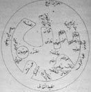
AL-BIRUNI, c.1029
|
=*Al-biruni's
view
of the world, Lahore, c.1029* |
|
AL-IDRISI, 1154
|
=*a world map by al-Idrisi, working in
Sicily, 1154** |
|
TRADE, c.1200s
|
=*Trade routes Europe-India, c.1200's**
(Shepherd 1923) |
|
the GHURID EMPIRE
|
=*The Ghurid
empire at its maximum extent, c.1206*
=*Ghurids
and
Mamluks, c.1170-1290**
|
|
the MONGOL
ONSLAUGHT
|
=*the Mongol
onslaughts and conquests, 1200's-1400's*; *a quick overview of the 1200's** |
the DELHI
SULTANATE,
4
OVERVIEWS
|
The
growth
and decline of the Delhi Sultanate, according to:
=*Joppen
1907*
=*Davies
1949*
=*Roolvink
1957*
and especially the DSAL zoomable edition of Schwartzberg
1978:
=*Sultanate
overview maps*
=*Ghurids
and
Mamluks, c.1170-1290**
=*Khaljis
and
Tughluqs, c.1290-1390**
=*political
disintegration
in the North, c.1390-1450**
=*the
time
of the Lodis, c.1451-1526**
|
MAPPA MUNDI, 1300
|
=*The
Hereford Mappa Mundi**
|
PTOLEMAIC ASIA,
1470's on
|
=*Ptolemaic maps-- some of the earliest
ever printed* (Rome, 1478)
=*An
early Map 9 from Rome, 1480's, and other examples*
=*An
early Map 10 from Ulm, 1482, and other examples*
=*An
early map from the Harley Collection*-- *more
information**
|
|
WORLD VIEWS, 1493
|
=*Asia and other maps and views,
Nuremberg Chronicle, 1493* |
|
GLOBE, 1502
|
=*The "Cantino planisphere," an early
globe, 1502** |
|
MUNSTER, 1544-
|
=*maps
and views from Münster's famous "Cosmographia"* |
|
the OTTOMAN EMPIRE
|
=*Byzantine Empire, Ottoman Turks, 1355**
(Shepherd 1923)
=*Ottoman Empire, 1451-1481
(Constantinople)** (Shepherd 1923)
=*Ottoman Empire, 1481-1683**
(Shepherd 1923)
=*Dismemberment after 1683**
(Shepherd 1923) |