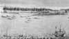
| The Coromandel Coast, c.1700's-1850's: ports (with forts) | |
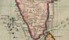 |
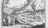
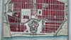
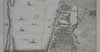
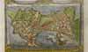
MAPS of the Coromandel Coast during this period; *maps from the 1740's*; and an *overview map from 1757* |
 |
The Coast begins to the south of the mouths of the Godavari river |
 |
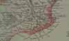
By the 1620's the Danes and the Dutch both were in the important cloth-trading port of MASULIPATAM, between the mouths of the Godavari and the Krishna |
 |
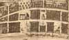
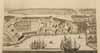
From the early 1600's the Dutch headquarters of PULICAT, with its fort called Geldria, figured prominently in trade and politics |
|
GEORGE* |
From 1640 the English had been in Fort St. George, as Madras was then known |
 |
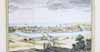
The Portuguese were in the port town of ST. THOMÉ (Mylapore) from the early 1500's |
 |
A little further south came the old Dutch fort of SADRAS, which grew into a great weaving center for fine muslin |
 |
PONDICHERRY was the headquarters town for *the French* |
 |
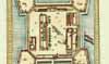
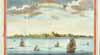
Then came the remarkable Danish fort at TRANQUEBAR, built in 1620 according to a *treaty* with the King of Thanjavur, and held by the Danes until 1845 |
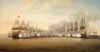 |
And NEGAPATAM, an early Portuguese fort and the scene of a French-English naval battle in 1782 |
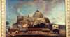 |
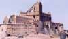
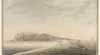
TRICHINOPOLY's fort was perched on a huge rock promontory, in the domains of the Navab of Arcot |
 |
Near the south end of the coast was TUTICORIN |
|
|
And then came Ceylon, which was an important part of the Coromandel trading network |
 |
JAFNAPATAM was at the extreme northern tip |
 |
On the east coast of Ceylon was TRINCOMALLEE with its excellent natural harbor |
 |
South of it was the smaller port of BATICALO |
 |
Then on the west coast was the fort/port of NEGOMBO |
 |
To the south of it was the large and important trading town of COLOMBO |
 |
And at the southern tip of the island was the Dutch fort of POINT DE GALLE |