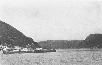
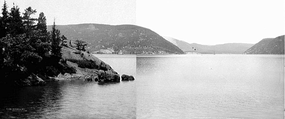
Dunderberg (left) and Anthony's Nose
Ships at Caldwell's Landing
The model for the Dunderberg Spiral Railway (DSR) was the Mumford brothers' Switch Back Railroad of Mauch Chunk, Pennsylvania. The cars there went up one inclined plane, coasted down a "back track", went up a second inclined plane, and coasted a short way again to the terminal, nine miles west of Mauch Chunk. The cars then coasted all the way back on the "down track". Despite the name, the part of the railroad used for the excursion service was relatively straight and was simply a "double-twisted figure 8", meaning the down track passed under the other line twice. One of the advertised features was reaching 50 miles per hour near the end of the down track.
But as successful as it was, the Switch Back was up in the Lehigh Valley, too far for a day trip from New York or Philadelphia. Dunderberg was close to New York. In the Prospectus of the Dunderberg Spiral Railway, issued in November 1889, H J Mumford gives a "lowest estimate" of 300,000 visitors per year, assuming only 6 hours of operation per day over a 150-day season, and he says he expects twice that. The ride was to cost 50 cents. With hotels, restaurants, and picnic grounds, the views of the Hudson and the Highlands, and the cool mountain air, and all of it only a two-hour boat ride from the city, how could it go wrong?
|
Dunderberg (left) and Anthony's Nose Ships at Caldwell's Landing |
The stock offering was for $750,000, with a mortgage of $650,000, and enough was raised to start construction in the spring of 1890. The company had acquired land in 1889, mainly from the Jones family after whom Jones Point is named, and in 1890, multiple work gangs began at various places on the route. Most of the completed work seems to date from spring to fall of that year.
The base station was to be a large building located at Caldwell's Landing, on the shore of the Hudson about a half mile south of Jones Point. Besides acting as the main station for the DSR, it would also contain the company offices, a large restaurant, and a hotel, and nearby would be a carbarn, engine house, and repair shops for the railway. An illustration in the Prospectus shows a long three-story building with towers and a central dome possibly reaching seven stories, and a two-story pier reaching out into the Hudson. There was to be a park of seven acres, and a covered iron bridge over the railroad to the pier.
The Hudson River excursion boats were considered the main way to get there, for pleasure traffic, and the pier was designed to accommodate three boats at once. The West Shore railroad, in operation for less than a decade, was also available as a faster route. Into the early twentieth century, some hikers from the city preferred to go up the New York Central to Peekskill and hire boats to cross the river.
If any of this was built, it is gone now. Gordon J Thompson's report of 1977 mentions some remnants of "stone foundations, shaped embankment, and piling", but whether this was DSR construction is unclear. The Hudson River Valley Atlas of 1891 shows that the highway was at that time on the water side of the railroad, and the base station is shown as an I-shaped building inside the DSR loop, which runs right alongside the West Shore railroad, where modern highway 9W is. Since the DSR is shown as completely constructed in the Atlas, it is safe to say it was depicted from plans and not surveys! The site of the base station has been completely disrupted by later sand or gravel quarrying, and whatever grading and foundations may have been built close to highway 9W have long since been destroyed.
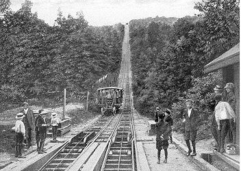 |
Car departing, pushed by barney Barney pit and special rails in foreground (from the Switch Back Home Page) |
The Prospectus describes two "double" inclined planes of 2500 feet, with an engine house and boilers at the top of each. It does not provide details of the incline operation, but since the inclines were actually built for single track, it looks like plans changed anyway. The Switch Back mechanically provided a fairly antiquated prototype from decades earlier, but since Mumford obviously had it in mind, its operation is worth a quick look.
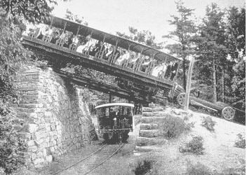
On the Switch Back's double-track inclines, a small unmanned car called a barney travelled up and down on each track, and provided the push for passenger cars. The barney was permanently attached to a "segmented iron band" that was wound up onto a drum at the top of the incline. Thus, in service, a passenger car rolled down a slight grade to the base of the incline, passing over a pit and coming to rest just past it. The rails around the pit were then separated, and the barney was pulled up from the pit and took its position behind the passenger car. The barney, drawn up by the iron band, then pushed the car up the incline. The car was not actually attached to the barney, and simply coasted away from it after cresting the top.
But it's not certain that barneys were planned for Dunderberg. That the Dunderberg inclines were built as single track does not rule out the idea, because the barneys did not counterweight each other anyway, and the reason for double track would be mainly to reduce the wait time between lifts. The lack of a barney pit at the base of the Upper Incline, however, does bring the idea into question. While the barney system eliminates the need for a cable grip on the cars, it also reduces line capacity. If instead the DSR adopted the system used for street cablecars by 1890, an endless cable loop, cars could be sent up a single track at any frequency desired. The simple cable grip used today for roller coaster inclines had not yet been developed in 1890, but perhaps some kind of grip was planned.
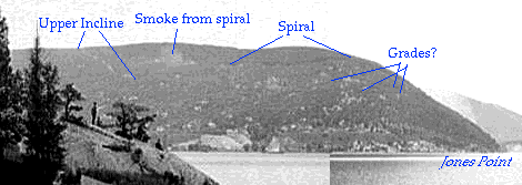
The two Dunderberg inclines are at about right angles. The Lower Incline rises about 590 feet in 2300 feet horizontal, and the Upper Incline rises about 320 feet in 1200 feet horizontal, grades of about 26 per cent. The inclines are linked by a three-quarter loop on a downgrade, so that the cars pass under the Lower Incline just before beginning the Upper, and the total rise is about 890 feet. The ride up both inclines was estimated at 11 minutes in the Prospectus, making about 4 miles an hour.
The grading for the inclines was completed except for the upper ends of both, the lower end of the Lower, and, curiously, all six crossing places over down tracks. The inter-incline loop has two incomplete rock cut sections. The Lower Incline has extensive erosion from a stream, as well as uncertain damage in a stretch up near the loop that Thompson calls "erosion or vandalism", and the Upper has one stream washout in a fill. Despite these gaps, it is relatively easy to follow the straight line paths of both planes all the way up the mountain. As with the down grade, the higher up the mountain, the better preserved the work.
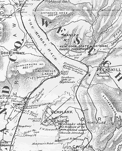 |
by Wallace Bruce (detail) |
The summit of the DSR is at about 902 feet. The reported height of Dunderberg has been diminishing over the past hundred years. The Hudson River Valley Atlas of 1891 has it as 1,025 feet, and a hikers' map by Hoefferlin in 1935 has it down to 940. On the other hand, Bruce's map of 1894 (shown here) gives it only 865 feet.
The Prospectus mentions a "tract of 20 acres" at the summit to be developed as a park with a station, a large hotel, and an observatory tower. The hotel site was not right at the top of the incline, but at high ground about a thousand feet east. Because the Hudson loops around Dunderberg, here at the summit, with proper tree trimming, there would views up and down the river for some distance.
The stream west of the summit was to be used for fresh water and hydropower. The pond located along the spiral grade around 800 feet looks like it has been formed by a hidden dam in the fill where the railway grade crosses its outflow. Farther down, just uphill from the Upper Tunnel at 600 feet, a dam was planned that would have flooded the natural basin there, which the Jones Trail, a construction road, passes through. This was not a major hydro project but was to take care of the summit facilities. It's possible the inclines would have been worked by electric motors, even though the Prospectus refers to boilers.
An "unfailing" spring known in later accounts is located just off the spiral, north of its present-day crossing of the Ramapo-Dunderberg Trail. This spring feeds the stream running north near the (unmarked) Bockberg Trail. Whether the DSR developers found it is not known, but it was exploited by 1906, when it supplied water for the builders of the modern highway 9W around the mountain.
The downhill grade is about 890 feet in nine miles, estimated by Thompson at 1.9%. It is constantly downhill, which simplifies the matter of coming to a stop at any point along the route. There were planned to be three stations along the down grade, at unspecified points, for picnic grounds and hiking. One stop may have been planned for the switchback turn out near Jones Point.
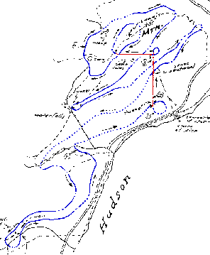 |
Gordon J Thompson's sketch map, 1977 |
The down grade follows the natural contour as much as possible, but the need to maintain a gentle but constant downhill path forced the construction of many cuts and fills. Its course is confusing but is basically two clockwise spirals followed by three switchbacks (long, U-shaped paths), of which the last is especially long and takes the cars to the farthest point from the base station, about 1.5 miles south.
The winding course was intentionally designed to offer "a surprise at every turn" and "a constantly changing view", according to the Prospectus. Take the hairpin turn near the Upper Tunnel: the tunnel itself is not visible till the last moment, and then as soon as the car passes out of the tunnel, it would go into a U-turn passing quickly from a rock cut to a high fill with a spectacular view down river. It looks as if the next hairpin turn out by Jones Point would also put the cars out on a fill with a view.
An obvious question is how fast the cars would have gone downhill. Was this a thrill ride? The Switch Back reached 50 miles per hour, some say 60, along a very straight stretch near the bottom. Speed had to be one of the attractions. But the sharp curves on the DSR rule out a constant high speed. It is possible they planned to let the cars go on the straighter sections and then brake them for the curves. They just don't say. There were going to be stops along the downgrade for picnic and hiking, so the cars would definitely have been run by staff who could operate brakes. Modern roller coasters use a system of speed retarders built into the tracks to regulate speed, but this had not been invented yet, nor would it be practical to install them on such a large coaster.
About two-thirds of the down grade was built. Work obviously was carried out by many crews starting at many points, and for different periods of time, which leaves segments of varying length with gaps between them. There is one long gap of just over a mile. It is therefore impractical to follow the complete grade, but many sections provide good hiking, and the easy grade makes a welcome way to cover some distance before striking out more steeply up or down hill.
 |
Barney pushing a car up the incline (from the Switch Back Home Page) |
The Prospectus suggests starting up with 15 open passenger cars, 2 closed passenger cars, 1 locomotive, and 7 freight cars (4 coal, 2 flat, 1 box). The down grade would be well within the capability of a steam engine, and although they don't say, the freight cars would presumably deliver goods to the summit after hours, and maintenance materials to any point along the line. The carhouse at the base was however to be large enough for 30 cars.
The width of the grade and the height of the tunnel and underpass show that this was to be standard railroad gauge with normal-sized cars, not narrow gauge or cars of an amusement-ride type. The open passenger cars would have been similar to open streetcars of the day (and to those used on the Switch Back), wooden bodies with benches across the width, possibly roll-down canvas for the sides in case of rain, and a solid roof.
One of the first jobs done must have been building the construction road now known as the Jones Trail. Built to nearly the quality of the DSR itself, with earth fills, one cut, and several small bridges and culverts, the road ran up from the shore road to the spiral at 800 feet. This road enabled construction of the grades up and down from the Upper Tunnel, and of the spiral segment sometimes called the Parapet Trail. Its lower portion is now part of the 1777 Trail (marked by diamonds with red 1777), and the rest, while unmarked, is easy for hikers to follow today, save for one short section washed out by a stream just uphill from the Upper Tunnel.
A very short construction road, included today in the Timp-Torne Trail, bypasses the Upper Tunnel so crews could build the grade uphill from it. There seem to be others, less well defined.
The failure of the company and the end of construction has been dated variously as spring 1891 or even late 1890. All that is known for sure is that the money ran out and that the workers left the job to be continued at another day that never came. A simple reminder of the sudden end are the drill holes in solid rock at the head of a few unfinished rock cuts-- made possibly on the last day of work.
 |
Dunderberg as seen from Charles Point, Peekskill |
Around 1892, the land went mostly to Rockland County or back to the Jones family. By 1900, limited logging was being done up on the mountain, and the area around the once-planned base station was disrupted by a company digging for sand and gravel. A new highway around the base of the mountain was built in 1907-1908, cutting through the approximate location of the base station along the land side of the West Shore railroad.
Bear Mountain State Park was established in 1910 in connection with the Palisades Interstate Park. The summit of Dunderberg was added to the park in 1913, and most of the remaining DSR right of way was added in 1938. The land was still close to untouched since the DSR. More of the mountain, including the sand quarry, was added in 1951. A few segments of the lowest downgrade, most of them close to highway 9W, are still privately owned.