The elevations used on the maps and in the text are all my own estimates based on plotting data from several sources onto the Peekskill quadrangle US Geological Survey map. All the data correlated. For example, Gordon J Thompson gives the incline as 26%, and I was able to fit that to the mapped contour of the mountain at the location he indicated. Likewise, using Thompson's value for the downgrade of 1.9%, I found it simple to plot out the route by simply marking dots at about 20 feet per 1000 (those dots can be seen on the topographic map) following the general plan on Thompson's map and other sources. Chances are I'm not exactly right, with no surveying done at all, and that's why I give the elevations rounded off to the nearest 10 feet or so... but I think it's pretty close. None of my sources gave spot heights for points besides the mountain peaks.
With two exceptions, I took all the color photographs on two days in October and November 1996. I used a Minolta SX-70 SLR 35mm camera with its regular 50mm lens and 200 speed Kodak film. The prints were scanned and slightly cropped. The numbers in the URLs are the order in which they were shot, and there are missing numbers because some of the originals were duplicates or otherwise not needed. Two photos, as noted, were taken by Michael Wares on the same days.
Because people ask... I did most of the work on a Macintosh Performa 575 with added memory, using Claris Works for the text labels and some of the pixel color changing on maps, and Graphic Converter to manipulate the JPG and GIF images. Some odds and ends were done on a PowerPC because it was handy, but the Performa has a better color screen. The html code is handmade with Emacs on a UNIX box.
The sketch maps of parts of the line were drawn by hand from my field notes. I scanned them and added notations also mostly from the field notes.
The photo "Southern Gate of the Highlands" and the detail from a map of the Hudson River are from the book The Hudson by Wallace Bruce, 1907, and later reprinted by the Walking News.
The two photos of the Switch Back are processed from images on the Switch Back Home Page, used by permission.
The general map of the DSR was processed from Gordon Thompson's sketch map, which is also here in full (see below). I converted the image to monochrome and then colorized selected pixels.
The "detail of a photographic panorama" is a marked-up detail from a larger image available here (see below).
The photographs are my own 1996 images, of places Howell saw. Howell was a photographer, and his photos must be around somewhere, possibly in New York Public Library.
This large image is itself a detail of a four-part panorama ( 1 | 2 | 3 | 4 ) by William Henry Jackson, "circa 1890". It comes from the Detroit Publishing Company collection at the Library of Congress. For more area photos, go to the main Detroit Publishing page and search under the words "Peekskill" and "Narrows". "Hudson" gets too much and "Dunderberg" gets nothing.
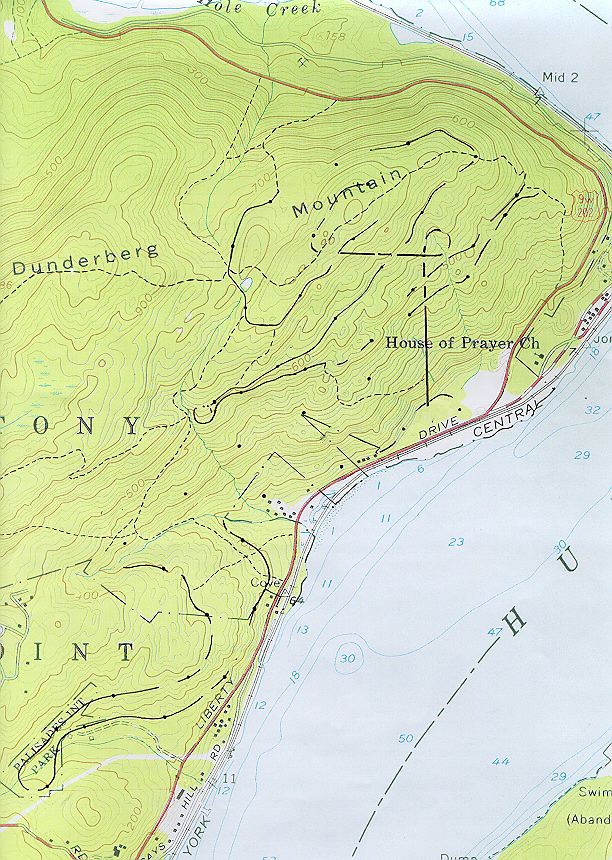
Detail of the Peekskill quadrangle, 7.5 minute series, US Geological Survey. I enlarged a portion of the original and added the DSR and some other detail by hand, and scanned the result. This scan is also the base for some other processed images on these pages.
The sketch map is from a three-page "Memorandum", two pages typed and one page sketch map, dated November 1, 1977, by Gordon J Thompson, Transit Coordinator, with the subject "Examination of Railroad Facilities / The Dunderberg Spiral Railway: Caldwells Landing to Summit". Thompson hiked the entire line on six dates from 16 November 1975 to 29 October 1977. I believe this is a State document.
The maps are made from the topographic map (above). The sources for trail information are mentioned on the page.