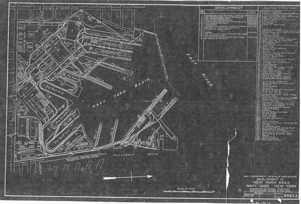
Map 1
This map shows the BNY's extent from approximately 1900 until the middle
of World War II and shows its buildings and grounds as of 1938.

Through most of the nineteenth century the navy yard covered all the
southern shore of Wallabout Bay. (see Map 2)  Beginning in the 1880s the
city of Brooklyn bought much of the eastern part of the bay, which was
then still mostly marsh.  Much of it was filled in and turned into the
Wallabout Market (in the map it lies below the Yard).

The navy yard in the meantime built a causeway out to what was previously
a small islet in the middle of the bay and converted it to the structure
shown in the bottom of the map.

The Yard in 1900 was missing the two building ways shown at the top of the
map.  One was constructed in 1903 in order to build the Connecticut,
the Yard's first modern battleship.  The second one was added during the
first world war.

The Yard's dry docks are numbered, from top to bottom: 1; 4; 2; 3.  The
first was completed in 1852, and numbers 2 and 3 in the last quarter of
the nineteenth century.  Number four was finished in 1914.

Many of the buildings shown here at the western edge of the Yard (top of
map) date back to the 1800s; many of the others were built or
reconstructed during the first four decades of the twentieth century.

Note: The circle was the projected site for the soon-to-be-constructed
Hammerhead Crane.  However, it was later built elsewhere (see Map 2).


J Stobo (c)