The shoreline is affected by waves (produced by wind at sea) and tides (produced by the gravitational effect of the moon and sun).
Waves
Waves are caused by wind. Wave height in the open ocean is determined by three factors. The greater the wind speed the larger the waves. The greater the duration of the wind (or storm) the larger the waves. The greater the fetch (area over which the wind is blowing - size of storm) the larger the waves.
Waves have crests (high spots) and troughs (low spots). The wave height (amplitude) is the difference in height between the crest and the trough. The wavelength (L) is the distance between two crests (or troughs). The period (T) is the time between passage of successive wave crests (or troughs).
Open Ocean Waves: As a wave passes, water molecules rise up and move forward (in the direction of wave motion) until the crest passes. After the crest the water molecules move down and backward. The result is that water molecules move in orbital paths as waves pass. This orbital motion is greatest at the sea surface and decreases with depth below the surface. At a depth of one-half the wavelength the orbital waver motion is nearly zero (actually 4% of the surface orbital diameter). This L/2 depth is considered wave base.
Waves at the Shoreline: As a wave approaches the shore it slows down from drag on the bottom when water depth is less than half the wavelength (L/2). The waves get closer together and taller. Orbital motions of water molecules becomes increasingly elliptical, especially on the bottom. There is a growing proportion of back and forth motion and less up and down motion as the wave moves through shallower and shallower water. Eventually the bottom of the wave slows drastically and the wave topples over as a breaker. The dominant sense of motion is now forward and backwards resulting in the forward swash of water followed by the backwash.
Coastal Sedimentation: In the wave dominated shoreface and nearshore environment fine sediments (silt and clay) remain suspended and are winnowed away, leaving behind the coarse grain sediments (sand and gravel). Suspended fine grain sediments are deposited offshore in deeper water where the bottom is stirred only slightly as depth approaches L/2 or not at all by waves (below L/2 depth). Therefore sand and gravel dominates the beach, foreshore, near shore. Sands become finer the deeper the water the farther offshore. Sandy bottoms give way to silt-dominated and then clay-dominated bottom sediments (muds) farther offshore and out across the continental shelf.
As a wave crashes on the shore, the water pushes sediment up the beach and then pulls it back down the beach as the water slides back down. If the waves do not come in parallel to the beach longshore transport (littoral drift) of sand occurs. When waves approach the beach at an angle, the part of the wave that reaches shallow water earliest slows down the most, allowing the part of the wave that is farther offshore to catch up. In this way the wave is refracted (bent) so that it crashes on the shore more nearly parallel to the shore. You will never see a wave wash up on a beach at a very high angle from the line of the beach except perhaps at an inlet or where the shore makes a sudden right angle bend. This wave refraction focuses wave energy around headlands and diffuses it in bays. Relatively large waves are found around headlands. Bays have quiet water (good for ship moorings) and are sites of deposition (nice sandy beaches).
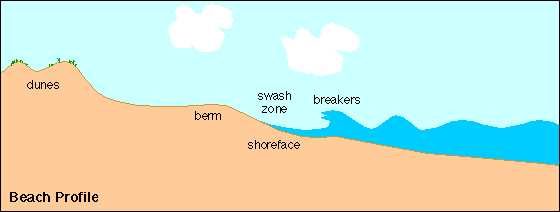
Beach Profile: Summer/Winter Profiles
During calm summer weather with waves gently lapping the shore the beach grows in size. Waves surge up the shoreface. The swash carries sediment. The swash slows, runs out of momentum, then slides back down toward the water. Some of the backwash sinks into the sand. The backwash has a little less energy to carry sediment down the beach so the beach gradually grows in size with the development of a summer berm. The summer beach profile is broader and with a more gentle slope.
During the stormy winter months, storm waves carry much energy to the beach with extra energy to suspend sediments and redistribute them in the nearshore environment. Steady strong winds from a storm can push water up on the leeward shore raising water levels. Return flow from this wind setup helps to carry sediment away from the shore. The summer berm is eroded away and the sands deposited offshore. The winter beach profile is steeper and narrower.
Tides
Tides result from the gravitational attraction of the sun and the Moon on the oceans. Tidal force is proportional to the mass of the attracting body and inversely proportional to the cube of the distance (tidal force µ mass / distance3). So even though the sun is much much more massive than the moon it is also much farther away. The net result is that the moon exerts about twice the tide force that the sun does.
Equilibrium Theory of Tides:
The Earth and Moon revolve around the center of mass of the Earth-Moon system which is called the barycenter. The gravitational attraction of the Moon pulls up a bulge of water on the side of the moon facing the Earth. The centrifugal force of the Earth's revolution about the barycenter causes a second bulge of water on the side of the Earth opposite the Moon (the Moon's gravitational forces are weaker on the far side of the Earth and the inertial or centrifugal effect is stronger). So as the Earth rotates on its axis, for any observer on the Earth there should be two high tides and two intervening low tides per day. The Moon rises about an hour later every day because it orbits the Earth in the same direction that the Earth spins on its axis. Therefore, the tides should be about an hour later every day.
As the Moon orbits around the Earth every four weeks, the relationship of the Sun, Earth, and Moon changes. At the full moon and new moon the Sun, Earth, and Moon are aligned. At these times the gravitational and centrifugal force of the Moon and Sun combine together. The resulting spring tides are the highest high tides and lowest low tides or the greatest tidal range during the course of the lunar month. At the first quarter and last quarter, the Sun, Earth, and Moon form a right angle. At these times the gravitational and centrifugal forces of the Sun and Moon act at right angles to one another. The resulting neap tides are the lowest high tides and highest low tides or the smallest tidal range.
Problems with the Equilibrium Theory: The equilibrium theory of tides requires that the Earth be covered with an ocean several thousand miles deep covering the entire Earth. Imagine the tidal bulges and troughs as waves on this ocean. Since the rotational speed at the equator is around 1000 miles per hour (25,000 miles per 24 hours) these waves would have to travel from east to west at 1000 miles per hour across the face of the Earth, at least near the equator. Also consider that the wavelength of one of these waves must be half of 25,000 miles. Bulge to bulge is 12,500 miles. Therefore wavebase (L/2) would be 6250 miles. A world encircling ocean would have to be at least this deep or the wave would be slowed by friction with the bottom and would not keep up with the Earth's rotation. Since the Earth's oceans are only on the order of 3 miles rather than 6000 miles deep and since continents litter the surface, the actual tidal pattern is not nearly as simple as the equilibrium model. Nevertheless, most places do have two high and two low tides per day and spring tides and neap tides at the expected times of the month.
Dynamical Theory of Tides:
In reality the global tides are organized into a number of tidal cells. Tidal crests rotate once every 12 hours around amphidromic points, counterclockwise in the northern hemisphere, clockwise in the southern hemisphere.
Distance to Moon and Sun
The orbits of the Earth about the Sun and the Moon about the Earth are not circular. They are elliptical. During its monthly orbit about the Earth, the Moon is sometimes closer and sometimes farther from the Earth. The Moon's tidal attraction is strongest at perigee (when the Moon is closest) and weakest at apogee (when the Moon is farthest). The Earth is closer to the sun during the northern hemisphere winter and farther from the sun during the summer. The Sun's tidal attraction is strongest at perihelion (when the Earth is closest to the Sun) and weakest at aphelion (when the Earth is farthest from the Sun).
Coastal Erosion
Sea Level Rise and Coastal Erosion
Sea level has risen by about 120 m (400 ft) since the peak of the last ice age about 19,000 years ago. The coast was about 100 km (60 mi) farther offshore from Long Island at that time. Since then ice caps have shrunk, returning water to the sea and the seas have warmed and expanded. Global average sea level is currently rising at the rate of about 2 mm per year. This slow sea level rise helps to increase the rate of coastal erosion. For example, along Long Island's south shore on Fire Island the shoreline is receding between 0.7 and 1 meter per year.
Coastal flooding and erosion may be severe when storms strike a coast at spring tide. Storms brought by low pressure systems may give rise to a large storm surge high water resulting from the combination of wind setup and an inverted barometer effect (low pressure doesn't weigh down as heavily on the surface of the ocean). Highest water occurs through the combination of storm surge at spring tide, especially at or near perihelion and perigee.
Coastal Erosion Control
Groins are structures built out from the shore at a right angle to the beach in an attempt to stop longshore sand transport. They hold the sand on the upcurrent side of the groin but the downcurrent side of groins faces enhanced erosion because sand transport from upcurrent is halted. Also, some sand is diverted offshore as longshore currents flow into deeper water around the groin. Jetties are groins built at an inlet to halt the migration of sand across the mouth of the inlet.
Seawalls are structures built parallel to the beach to protect buildings. When storm waves strike a seawall, the unspent wave energy is reflected back offshore. This is good for the building, but that extra energy carries sand offshore. Result: the beach is gone. The seawall will eventually be undermined and the building washed away if the sand is not replenished. In the meantime there is no beach for recreation.
Beach Nourishment: Many beaches in developed areas are not allowed to migrate shoreward with the rising sea. Owners of homes and commercial properties attempt to protect them with groins and seawalls. Large stretches of the eastern seaboard of the U.S. have become armored shorelines with little or no beach, perhaps just a thin strip of sand lying in front of a seawall at high tide. Recreational value is much diminished and the threat to buildings during storms is high. A common recourse is beach nourishment. Sand is pumped onto the beach from offshore, thereby rejuvenating the shore. The process of moving huge quantities of sand is quite expensive, costing millions of dollars for a modest project. Beach nourishment is often done by the Army Corps of Engineers, to protect lives and property, and using taxpayer dollars. However, this is usually a very temporary solution. Beach nourishment increases the slope of the beach which makes it easier for continued erosion. The sand that is pumped from offshore is typically finer than the original beach sand making it easier to erode. The result is that much of the new sand may be washed out in one or two major storms. These beaches commonly lose all of this pumped sand within five years or so.
Dune Stabilization: Coastal dunes form an important barrier to strong storm waves. In the past they were leveled and built upon. Elsewhere, they were trampled by beach goers, killing the dune grasses that kept the sand from blowing away. In recent years many dune protection programs have been put in place to enhance this natural line of protection against the sea. While this is wise, it does not form a permanent, demarcation between the land and the sea. As sea level rises and the shoreline recedes, the dunes will naturally recede landward also. But if they are artificially maintained by planting vegetation, the beach itself will continue to narrow until the shoreface impinges on the dunes. Eventually the dunes wash away and so too the property behind them.