Earthquakes
As the lithospheric plates of the Earth continue their slow motions, stresses build up in the crust, especially near the plate boundaries. Those stresses (compression, tension, shear) build up in the crust until the stress exceeds the strength of the rock or the friction along a preexisting fault. Then, sudden slippage of rock along a fault occurs. The ground shakes as the stress energy is released and the rocks lurch to their new position in a matter of seconds. Seismic waves travel outward from the portion of the fault that broke, like expanding ripples from a pebble dropped in still water.
The whole fault doesn't move at one time; only the part of the
fault around which the stress exceeded the strength.
Seismologists can determine the point on a fault where the slippage
began, the area (length and depth) of the fault that slipped, the
amount of slippage or fault throw (how far the crust moved), and the
time it took for the slippage to occur. The focus or
hypocenter is the exact position on the fault, including the depth, where the slippage began. The epicenter is the map position of the Earthquake. It lies directly over the focus.
Seismic Waves
Body Waves - travel through the interior of the Earth
Surface Waves - travel along the Earth's surface. They are slower than body waves. They do the damage in Earthquakes.
Seismometers work on the principal of a heavy suspended inertial mass that doesn't move as the ground moves. If properly suspended, the mass forms a stationary reference point from which up-down, north-south, or east-west ground motions can be measured, for example with a stylus attached to the mass.
Earthquake Location
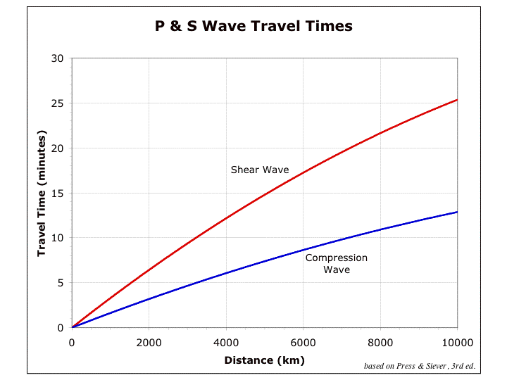
distance: P and S waves travel at known velocities through the Earth. S waves are slower than P waves by a known amount. As the P and S waves travel out from an earthquake the P waves get progressively farther ahead of the S waves. Therefore, the farther a seismic recording station is from the earthquake epicenter the greater will be the difference in time of arrival between the P and S wave. The distance of a seismic station from an earthquake is easily determined from the S-P interval, the time difference between the time of arrival of the first P wave and the first S wave.
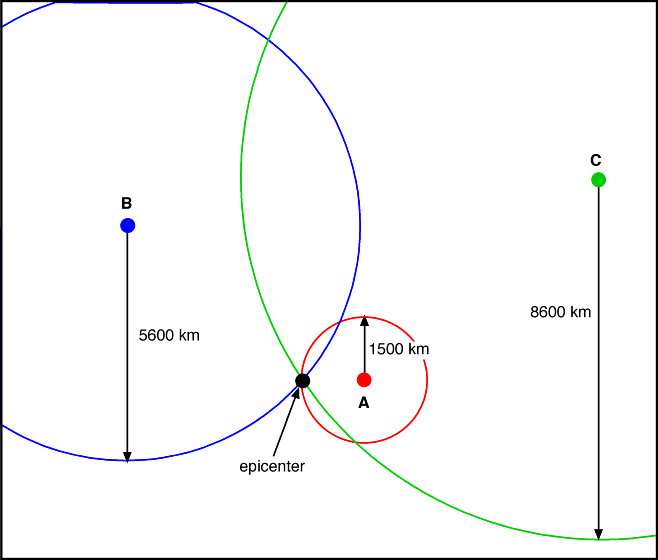
triangulation: To determine the location of an earthquake the distance of the earthquake must be determined from at least three seismic recording stations. Circles with the appropriate radius are then drawn around each station. The intersection of three circles uniquely identifies the earthquake epicenter.
Earthquake Magnitudes
Richter magnitude: The Richter magnitude is a measure of the amplitude of ground movement. Because the amplitude recorded on seismograms will decrease with increasing distance from the earthquake the distance must first be determined so that it can be corrected for. The Richter magnitude of an earthquake can be easily determined from the S-P interval combined with the maximum motion recorded on the seismogram. The Richter magnitude is recorded on a logarithmic scale on which an increase of one represents a ten times increase in amplitude. For example, a magnitude 5 earthquake produces ten times greater ground motion than a magnitude 4 earthquake.
moment magnitude: Moment magnitudes measure the amount of stress energy released in an earthquake. They are calculated after determining the fault throw (distance the fault moved), the area broken on the fault (depth and length), and the rigidity of the fault rocks (the springiness of the rocks). Moment magnitude is also recorded on a logarithmic scale on which an increase of one represents a 32 times increase in the stress energy released.
Mercalli intensity scale: In order to better understand
the long term behavior of a given fault it is necessary to go back to
written records of earthquakes that occurred before seismic recording
began. An intensity of I (not felt) to XII (total damage) is
designated according to the amount of damage cited in historic
records. The Mercalli intensity of historic earthquakes can then be
compared to the Mercalli intensity of modern earthquakes that have
Richter and/or moment magnitudes. Complicating factors include
differences in building design (weaker vs. stronger buildings) and
geology (solid bedrock yields less shaking, loose sediments and
landfill yield much more shaking).
Determining Richter Magnitudes
The magnitude of an Earthquake is measured on the well-known Richter Scale. To determine the Richter magnitude of an earthquake, seismologists need to know the distance to the earthquake and the amplitude of the surface wave at the recording site. The distance of the seismic recording station from the earthquake epicenter is determined from the time difference between the first arrival of the P-wave and the S-wave. This is known as the S-P interval. The recorded surface wave amplitude, measuring how many millimeters the ground moves at the seismic station, will depend on the distance from the earthquake epicenter and the magnitude of the Earthquake. Once determined from a seismograph record, the S-P interval and amplitude are used to mathematically solve for the magnitude, or they may be plotted on a graph called a nomogram to yield a visual solution for the magnitude.
First Motion Studies
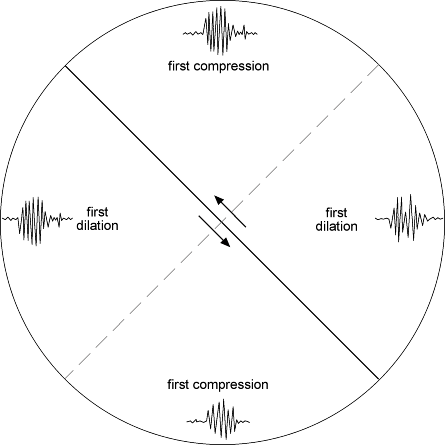
The type of fault motion causing an earthquake can be determined by
analyzing the first sense of motion (compression or dilation) recorded on seismograms in all directions and various distances from the earthquake. Some will record an initial
"up" (compression) on the seismogram indicating that the crust moved toward that direction and others will record an initial "down" (dilation) indicating that the crust moved away from that direction. The
pattern of "ups" and "downs" recorded around the earthquake epicenter
will indicate whether the fault was a thrust, reverse, normal, or
strike slip.
This figure shows the pattern of first compression and first dilation surrounding the epicenter of a strike-slip earthquake.
Seismic Risk Assessment
Earthquake Prediction (?): Numerous factors have been proposed as possible precursory signals that an earthquake is imminent including changes in low magnitude seismic activity in the weeks and months preceding a major quake, changes to groundwater levels, radon and other gases in groundwater wells, changes in the electrical resistivity of the crust (related to changes in groundwater distribution in rock as it begins forming microcracks immediately prior to an earthquake, changes in seismic wave velocity in the crust surrounding a fault that is beginning to fail prior to an earthquake, even strange behavior by animals just prior to a major earthquake. To date, no predictive factor or group of factors has been found to allow the prediction of an imminent earthquake.
Earthquake Probability: Seismologists are, however, able to estimate the probability of an earthquake of a given size occurring in a given period of years on a particular segment of a fault. Probability estimates utilize such information as the past history of earthquakes on the fault (size and average time between), magnitude and age of the most recent large earthquake (and the amount of stress released), rate of stress buildup in the plate boundary region based on the velocity of relative plate motion and regular monitoring of elastic strain buildup through survey techniques, and estimated strength of the fault (rock strength and friction).
While the frequency of earthquakes is much greater in areas around tectonic plate boundaries, where the stresses build up quickly, there are locales in the middle of plates, far from active faulting where stresses nevertheless build up on ancient faults potentially leading to major earthquakes (for example, the New Madrid fault zone on the Mississippi River).
Seismic Gaps and Sequences: Segments of faults that have not had significant earthquakes (stress release) in some time are more likely to have an earthquake sooner than segments that have had more recent earthquakes.
In Turkey, since 1939 there has been a westward progression of damaging earthquakes on segments of the North Anatolian fault. The most recent one was a 1999 earthquake that caused major damage and many deaths in the city of Izmet. Based on the sequence, the great city of Istanbul appears to be next.
Damage Factors:
- Loose, unconsolidated sediments, and especially saturated sediments experience stronger ground motions in an earthquake as compared to solid bedrock. Damage to structures is least where built on solid bedrock.
- Buildings have their own natural vibration frequency, like a tuning fork, depending on their height and rigidity. Given the natural vibration frequency of the rocks or sediments upon which the building are constructed, buildings of a particular height range are most susceptible to damage in strong earthquakes.
- Unconsolidated sediments may undergo liquefaction in a strong earthquake allowing buildings to sink, usually one side more than the other so that the building topples.
- A "seismic bounce" causes stronger than expected ground motion at a distance from an earthquake epicenter where reflected seismic waves combine with direct-arriving seismic waves.
- Strong earthquakes typically break underground gas lines leading to fires. Water lines also break making it difficult to fight the fires.
- Strong earthquakes that offset the seafloor produce tsunamis, which are not normally discernible from a ship at sea with their very long wavelengths, but as theses very rapidly moving waves come into shallow water approaching the shoreline they slow greatly, getting steeper and much higher innundating low-lying coasts.
- Earthquakes may also set landslides and mudslides in motion, burying whole neighborhoods.