|
|
by Joseph Brennan. Copyright 2001, 2002. |
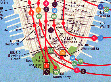
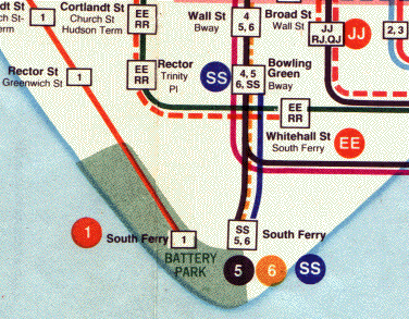
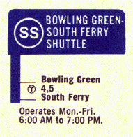
Bowling Green shuttle platformPassenger service: 1909 - February 1977. Existing abandoned portions: 1 track and island platform. Touring: 4 5 trains to Bowling Green. From the south end of the island platform, the abandoned shuttle platform is in plain sight. South Ferry inner loop platformPassenger service: July 1918 - January 1977. Existing abandoned portions: 1 side platform (on a track in service). Touring: 1 9 trains to South Ferry. The arched openings to the inner loop platform are on the other side of the two tracks, best seen when the station track is clear. Look out the left side of a train approaching the station, to see how much longer the inner loop platform is. On weekends or evenings, when the 5 train terminates at Bowling Green, look for it passing by on the inner loop track. construction and operationThe subway route down Broadway in the financial district to South Ferry and Brooklyn is part of New York's original subway project, the extension called Contract 2 that was added to the original subway route while it was still under construction. The first part of the Contract 2 route opened to South Ferry in 1905, just a year after the main line. At that time, local trains terminated at a loop at Brooklyn Bridge (as the 6 train still does), and express trains continued to the new route, terminating at another loop at South Ferry. The plan was that later some of the express trains were to run to Brooklyn instead of South Ferry, once the tunnel was opened. Bowling Green station had one platform, an island between the two main tracks. At South Ferry loop there were two tracks, but only the outer track had a platform, the platform now in use by 1 9 trains. The purpose of the inner track was probably to hold an extra train at the terminal. Once the tunnel to Brooklyn was opened in 1908, its traffic proved so heavy that it it would obviously be necessary to route all the express trains to Brooklyn to handle the passengers. It is unclear now why this was a surprise. Traffic on the Brooklyn Bridge railway, to that date the only rapid transit link to Brooklyn, was absolutely phenomenal and required crowd control measures of a degree never undertaken on any other transit route. Although for ten years the subway extended only as far as the Long Island Railroad terminal at Atlantic Ave and thus had limited coverage of Brooklyn residential neighborhoods, still its much better distribution in Manhattan attracted a large number of Brooklyn riders from the elevated and streetcar lines. The Public Service Commission reacted to the problem immediately by authorizing a short extra platform and track at Bowling Green, so that a shuttle could be run from there to South Ferry during weekdays, and all mainline trains could go to Brooklyn. Construction began only three months after the subway opened. The project involved a new 140 foot stub track and platform at Bowling Green, about 122 feet of new trackway out of it, and two crossovers between the loop tracks. The original west wall was removed near the south end of Bowling Green station, and space was dug out for the stub track and platform. Three elevated railroad columns had to be supported. An underpass was created under the main downtown track to provide access. It was all done very quickly and opened in the middle of 1909. The shuttle was one train of two or three cars that ran back and forth on the same track, reversing direction at South Ferry outer loop. At nights and weekends, the shuttle did not run and some of the mainline trains went to South Ferry instead. When the Seventh Ave subway was planned under the Dual Contracts system in 1913, the Public Service Commission decided to route the Seventh Ave local service into South Ferry, and to construct a platform on the inner loop to handle the shuttle and mainline trains from the original subway, which became the Lexington Ave subway. The inner loop platform was built for ten car trains so that Lexington Ave express trains could spot all cars at the platform, but the outer platform was left at its short length because only local trains would use it. At that time local trains were six cars. Because of the sharp curve, it was obvious that trains on the inner loop could open only their center doors, and so instead of a full platform face, slightly arched openings were cut into the old walls, centered about 51 feet apart, where doors would open. This plan contributed to safety, and must also have simplified the civil engineering involved, compared to removing all of the inner wall. Train operators are familiar with hitting a stop mark at all stations, so it was not overly difficult to line up the doors. The conductor's ability to see train doors however was severely limited. Operations changed little from 1918 to 1960. During this period, shuttle trains used the inner loop during the day on weekdays, and at nights and weekends Lexington Ave express or local trains used it. Only Seventh Ave trains used the outer loop. The South Ferry stations had separate entrances, and passengers could not transfer free between the two IRT lines. A new generation of subway cars forced changes. There was no longer a control to open the center doors separately, so from about 1960, the Lexington Ave mainline trains were routed to the outer loop during the hours they ran, and only the weekday daytime shuttle still used the inner loop. For the shuttle, eventually a train was assigned of newer subway cars mechanically altered so only the center doors would open. The city's financial crisis in the 1970's caused the Transit Authority to cut some services, among them the shuttle. Major reconstruction at Bowling Green had already been funded, and as completed in 1978 it included a renovated platform for a shuttle train that no longer ran. Service to South Ferry by Lexington Ave mainline trains was discontinued at the same time. Local trains (6), which had run down to South Ferry at night, now terminated at Brooklyn Bridge as they did during other hours. Lexington Ave express trains that formerly ran to South Ferry evenings and weekends (5) now nominally terminate at Bowling Green, but actually run around the inner loop at South Ferry, without making a station stop. The outer loop platform has never been lengthened, and only the front half of 1 9 trains stops at the platform. Passengers on arriving trains are told to walk forward through the train to leave at South Ferry. Gap fillers were installed in 1916 to protect the end doors, and a new installation in 1956 finally allowed all doors of modern cars to open, but of course, only on the first five cars that are at the platform. In January 2002, the MTA announced its intention to rebuild South Ferry to handle full length trains (without using the inner loop) while the line was closed because of the impassable section at Cortlandt St where the World Trade Center south tower had collapsed onto the subway. However the need for early relief on the Seventh Ave subway finally won out. The only work done at South Ferry was the addition of new stairways, and the trailing single crossover south of Rector St was made an X crossover so that 1 9 service will be able to terminate at Rector St during a South Ferry reconstruction later on. South Ferry was reopened in September 2002. In the first half of 2004, reconstruction plans were announced that called for a new South Ferry terminal without a loop to be located under State St and the ferry plaza, with passageways connecting to the ferry terminal and the Whitehall St station of the Broadway subway. |
diagram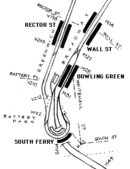
Bowling Green station now consists of two open platforms: the original center island, now used only for southbound trains, and a new side platform added in 1978 and used for northbound trains. The third short platform on the west side was used for the shuttle. When the shuttle was not running, the train stood in the stub track and its platform was closed. The stub track connects only to the west side of South Ferry loop, so the train reversed at South Ferry and came back on the same track. The shuttle route did not cross the path of any other trainroutes. Trains from the Bowling Green mainline track can run to either loop track and return. Trains from the Seventh Ave subway (Rector St station) can run forwards only to the outer loop track, the routing taken by 1 9 trains. Construction of the Seventh Ave subway connection included a flyunder for Seventh Ave trains going back uptown, to avoid a grade crossing. The old route to Brooklyn is chained as IRT route M (mnemonic "mainline") measured from Brooklyn Bridge. Seventh Ave is chained as IRT route V (mnemonic "Varick") from Times Square, but the loop has its own chaining MV from the southbound junction of M and V. Route M runs under South Ferry station on its way to Brooklyn, the tracks spreading to enter two separate tubes. |
|
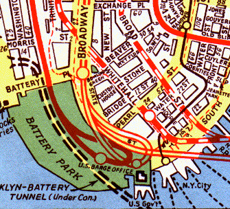
The Hagstrom street map designed in 1934 depicted South Ferry as two overlapping loops and two stations, which served to show that there was no free transfer at South Ferry, but which made the layout look even more amazing than it is. The correct position of the station is where the two lines cross over the word "office". Also shown here in a 1945 edition are the BMT subway in Whitehall St, which crosses under Bowling Green station on its way to Trinity Place, and in black the Third Ave El and the old (1878) elevated South Ferry station. |
|
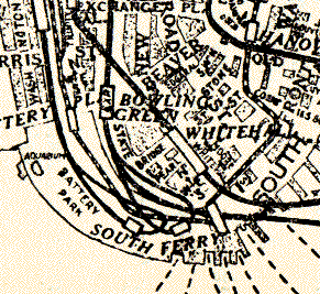
Before Hagstrom, a street guidebook from the Travelgide [sic] Company called How to Find Your Way in New York also depicted South Ferry as two overlapping loops. The detail here is much enlarged from one of the sectional maps in the 1928 edition of the guidebook. I don't know whether this is an early work of Andrew Hagstrom, but the similarities are striking, considering that there are not really two loops as shown. |
|
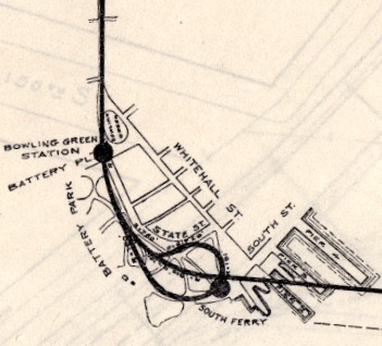
A detail from a general plan of Contract 2 from June 1902, just before construction, shows the correct position of South Ferry loop. Board of Rapid Transit Railroad Commissioners. From their Report. . . for the year ending December 31, 1903, New York: the Commission, 1904. |
|
|
|
This detail from a 1960 edition shows problems with the dot screen (south of Rector St) and stray lines (across the Lexington route near Bowling Green and at the loop return), probably introduced when the elevated lines to South Ferry were removed during map revisions in 1940 and 1955. |
|
The Transit Authority map of circa 1960 showed South Ferry as two separate stations. By this time, the night and weekend service from Bowling Green really used the same platform at South Ferry as the trains from Rector St, an unadvertised free transfer. |
|
The 6 train is shown as a dashed line because it only ran at night. The use of dashed lines on this map is inconsistent. The EE service (on the BMT line to Whitehall St) is de-emphasized with a dashed line, but ran about the same hours as the 5 to Brooklyn and the SS from Bowling Green, both shown solid. The 5 to South Ferry ran even fewer hours, only evenings and weekends, and is also solid. The hours of service were clarified in the strip maps on the back of the 1967 handout map. |
|
|
|
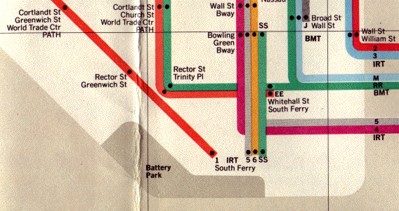
The Transit Authority map of 1974 continued the tradition of incorrectly showing the 5 6 SS trains all going to the same South Ferry station separate from the 1 train. All SS shuttle trains were shown in green on this map. This design avoided the problems with dashes by using only solid lines, but it meant that trains running only at night or rush hours were shown with the same emphasis as 24-hour services. It might appear that three train services ran to South Ferry at the same time. |
|
In 1976 the MTA issued a guidebook called Seeing New York: The Official MTA Travel Guide. It included, spread over many pages, a unique subway map probably by John Tauranac that overlaid the subway lines over scale streetmaps. This was the only official map that actually showed the 1 and 5 trains going to the same South Ferry station, and the SS train going to its own station, although it is still not clear that the two stations are immediately adjacent (in fact, their locations are shown similar to where they are on the Hagstrom street map). About a year later, the shuttle was closed. |
|
|
|
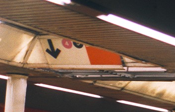
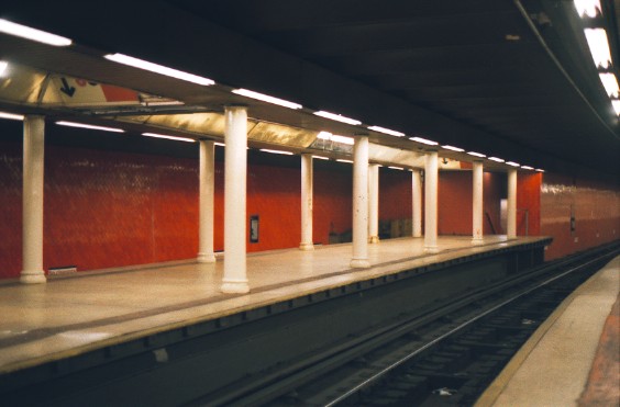
Seen in 2001, the abandoned Bowling Green platform was well lit and clean, and the only sign it is never used is that the finished floor installed in 1978 is starting to come up in places. The stairway at at the uptown end is its only access to anywhere. In the ceiling there is still a vintage sign directing passengers to the maroon 4 and black 5 trains. |
|
|
|
|
|
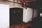
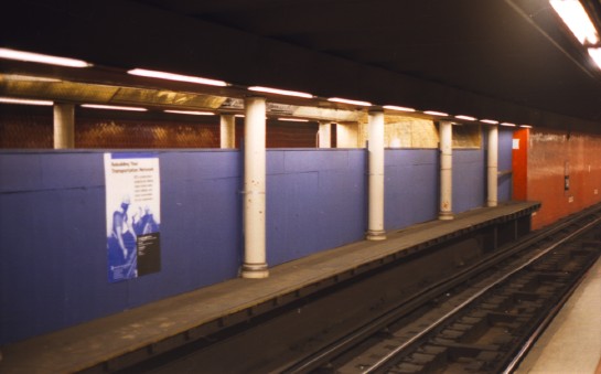
The view in 2002 is obstructed by plywood panels. A sign says the work will be done in 2004. 
|
|
|
|
... photos of Bowling Green station can be found on the New York Subway Resources site, http://www.nycsubway.org. |
![]()
 The IRT's official map showed its subway division in black and the
elevated division in grey or color. The subway loop at South Ferry
and its relationship to Bowling Green is accurate, but the connections
to the Brooklyn route and to the Seventh Ave subway are very
unclear. The connection from the loop back to the Seventh Ave line is
simply missing. The designer did not fully resolve the problem of the
Brooklyn route, although he realized that for clarity it should not be
shown in its true position passing directly under South Ferry station
(see the track diagram above).
The IRT's official map showed its subway division in black and the
elevated division in grey or color. The subway loop at South Ferry
and its relationship to Bowling Green is accurate, but the connections
to the Brooklyn route and to the Seventh Ave subway are very
unclear. The connection from the loop back to the Seventh Ave line is
simply missing. The designer did not fully resolve the problem of the
Brooklyn route, although he realized that for clarity it should not be
shown in its true position passing directly under South Ferry station
(see the track diagram above).
 The classic Hagstrom subway map designed in 1936 solved the problem of
the Brooklyn route elegantly. It also followed the Hagstrom device of
showing South Ferry as two loops, but shows it as only one station,
where the loops overlap. Things like this inspired generations of
boys to go ride the trains and see what was really there. The single
station circle may have been used simply to save space.
The classic Hagstrom subway map designed in 1936 solved the problem of
the Brooklyn route elegantly. It also followed the Hagstrom device of
showing South Ferry as two loops, but shows it as only one station,
where the loops overlap. Things like this inspired generations of
boys to go ride the trains and see what was really there. The single
station circle may have been used simply to save space.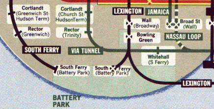
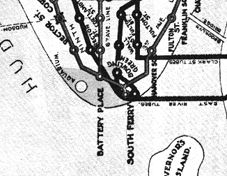
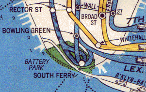
 The Transit Authority map of 1967 continued to show two separate
stations at South Ferry. This was the first map to show train routes
in separate colors, but it failed to take advantage of this and showed
the 5 6 SS trains all going to the same station.
The Transit Authority map of 1967 continued to show two separate
stations at South Ferry. This was the first map to show train routes
in separate colors, but it failed to take advantage of this and showed
the 5 6 SS trains all going to the same station.