|
|
by Joseph Brennan. Copyright 2001, 2002. |
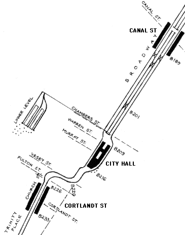
City Hall (BMT) lower levelPassenger service: Never completed.Existing abandoned portions: 2 island platforms on 3 tracks (used for train layups). Touring: N R trains to City Hall. Note the stairs to the lower level. Also, look out the front train window running from Canal St to City Hall, to see the center tracks running down to the lower level. construction and operationThe Broadway subway south of 9 St was planned in 1908 as part of the Triborough System plan, and construction started in 1912 even as the Dual System was being worked out. As planned for the Triborough, the four-track main line would diverge to two levels at City Hall, with a terminal for the local trains on the upper level, and a through station for express trains below. Just south of here, Broadway was occupied by the original subway, so the express line was to take a reverse curve and continue down Church St and Trinity Place. The station and approaches on both sides conform to the Triborough plan. Under the Dual system adopted in 1913, the Brooklyn Rapid Transit system was to operate the Broadway route. North of Canal St, a junction was retrofitted into the nearly completed subway structure, taking the express track downgrade and into a crosstown link to the Manhattan Bridge. Track on the original grade of the express tracks resumes at bumpers in Canal St station, and the four track subway continues to the planned divergence north of City Hall station, with the center "express" track running downgrade to the lower level and the outer local tracks running to the upper level station. South of the station, the tunnel was rebuilt with ramps to bring the upper level tracks downgrade to the original "express" grade just in time for the curves crossing over to Church St. The lower level was never used for passenger service, so it was never finished with tile nor signs. It and the rump express track up to Canal St were found useful for holding trains in Manhattan, so the tracks have been in regular use for daytime storage of excess rush hour trains. A famous incident in construction of the station was the so-called rediscovery of the Beach Pneumatic Transit demonstration subway, which lay mostly within the limits of the present station. Contrary to stories in several modern subway books, workmen did not break into the Pneumatic by surprise. On the contrary, the day the contract was awarded to Degnon Contracting, the first thing company and city officials did was to take possession of the tunnel, by entering it through the fairly large and obvious grate off the sidewalk between Warren St and Murray St. The Pneumatic tunnel was engulfed by the new work and completely destroyed by the end of 1912. A second legend has it that a plaque commemorating the Beach Pneumatic was placed in the lower level some years later. It is certainly not there now, and it would be a strange place to put it, where no one can see it. The source of the story appears to be a small newspaper article in the mid 20th century about a plan for a plaque. |
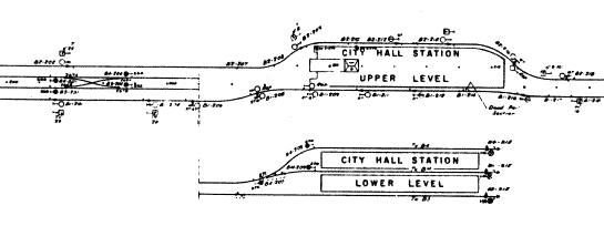
diagram
The diagram shows how City Hall station stands at the downtown end of a four-track subway. The center tracks out of City Hall lower extend to bumpers near the north end of Canal St station. Beyond that, the express track can be seen rising from the Canal St route (from the Manhattan Bridge). The lower level floor continues south of the station until it disappears under the increasingly low ceiling under the ramps carrying the upper level downgrade. |
|
|
|
A Transit Authority diagram shows the station to scale. The station is off center to the east (top), because it is close to the surface and the entrance stair from the east sidewalk of Broadway has to come down over a platform area. The upper level has a wide platform over the three-track lower level, so the fare controls are in the central area, and so is a control tower at the uptown end. |
|
|
|
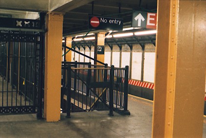
The only stairway to the lower level is in plain sight on the downtown side of the open upper level platform. It's marked with a big "No entry" sign. The gate has a brass rail across the top. To the left is a corner of the fare control area. |
|
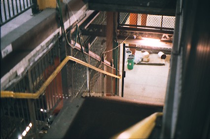
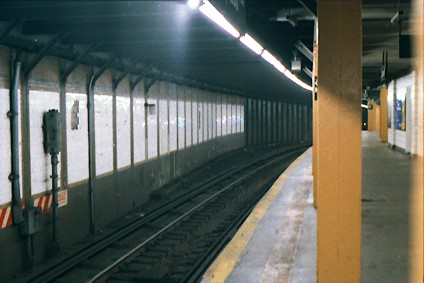
In mid 2001, a repair project was underway on the lower level, and a work light left on gave an unusually good view of parts of the center track and west side island platform. Usually it's pretty dark down there. |
|
|
|
One of the oddities of the station is where the track curves away from the side wall, at the south end of the uptown platform. It looks as if a sharper curve had been eased, but the columns on the platform side would have had to be moved. Instead it may date from the original construction when the upper level was converted from a terminal with presumably a straight line to end of track here. |

|
|
|
![]()