|
|
by Joseph Brennan. Copyright 2001, 2002. |
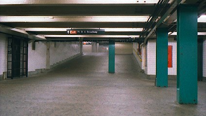
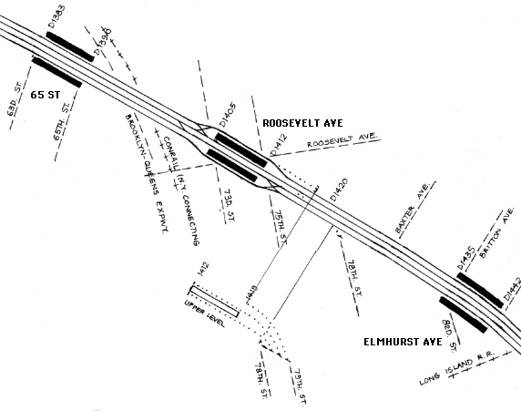
Roosevelt Ave upper levelPassenger service: Never used. Existing abandoned portions: 1 platform between two trackways. Touring: E F G R trains to Roosevelt Ave. The upper level station began at the east end of the mezzanine. Part of the space is a Transit Police station. construction and operationThe Queens Boulevard subway was part of the Independent Subway planned by the Board of Transportation in 1924. It opened in August 1933 as far as Roosevelt Ave, December 1936 to Union Turnpike, and April 1937 to 169 St in Jamaica. The subway has several provisions for extension to additional Independent Subway routes announced in 1929 and known as the Second System. At Roosevelt Ave, an upper level terminal station was built for a Second System route and never used. The upper level station is on the same level as the mezzanine of the open station and is sited just east of it. The terminal had a center island platform with a trackway on each side. The terminal is different from other provisions for the Second System in that the entire station was built and finished to the tilework. Even some portions of the First System that were not used right away, like the lower levels at 42 St and Bergen St, were not finished. The unbuilt route beginning at Roosevelt Ave was to run south via various streets and Fresh Pond Road to Central Ave in Glendale, where it would meet another route from Manhattan, and the combined lines would run parallel to, or in, the Long Island Railroad line to Woodhaven and the Rockaways. Most of the terminal and unused trackways sits unused to this day. Part of the terminal closest to the open station was converted to a Transit Police station. diagram |
|
From the upper level terminal, two trackways run above the main line as far as 78 St, where they turn south and end at the limits of subway construction for the open Queens Boulevard line. A ramp comes off the Manhattan-bound local track up to the same level and also crosses over to the same limits. On the Jamaica-bound local track, a stub turns off to the same limits, on the main track level. The stub ends all point to the block between 78 and 79 Streets. The first block was cleared and is now a playground. |
|
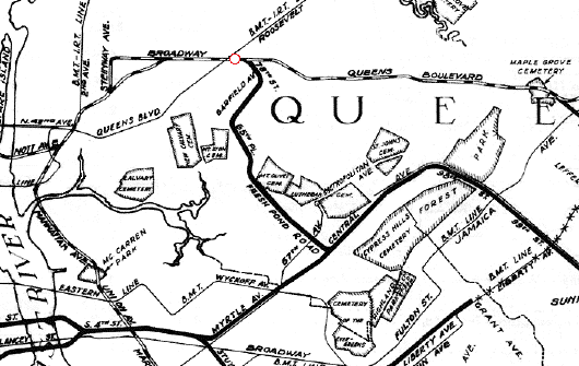
A Board of Transportation map from 1929 shows the proposed route south from Roosevelt Ave, the superimposed red circle. The constructed First System is in alternating black and white, and the never-built Second System is thick solid black. From Proposed Additional Rapid Transit
Lines. . ., a map made by the Board of Transportation in 1929 and
included in full in Twelve Historical New York City Street and
Transit Maps, H & M Productions, 1997.
|
|
|
|
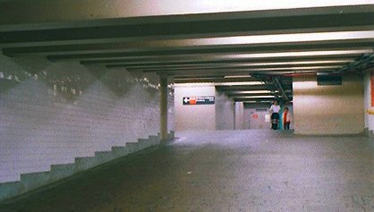
To reach the abandoned station, go to the mezzanine and exit at the east end, marked as 75 St & Broadway. The wide passageway goes up a ramp and ends where cinderblock walls block the rest of the original space. The unused station starts just inside the walled area, in the Transit Police station. |
|
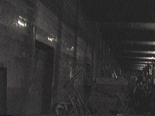
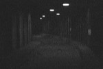
Behind the cinderblock walls and beyond the space that is lighted and in use is the really abandoned part of the station. A frame from a video by Mark Feinman shows the tiled side wall, a pile of old stuff in the trackway, and, dimly, a tour group on the platform, right. The tile is dark blue with black border, seen better in Joe Korman's photos (link below). Copyright by Mark Feinman. From Roosevelt Ave Terminal Station at the New York Subway Resources site. |
|
|

|
|
|
![]()