
What is GIS?
"A system of hardware, software, data, people, organizations and institutional arrangements for collecting, storing, analyzing, and disseminating information about areas of the earth." (Dueker & Kjerne, 1989)
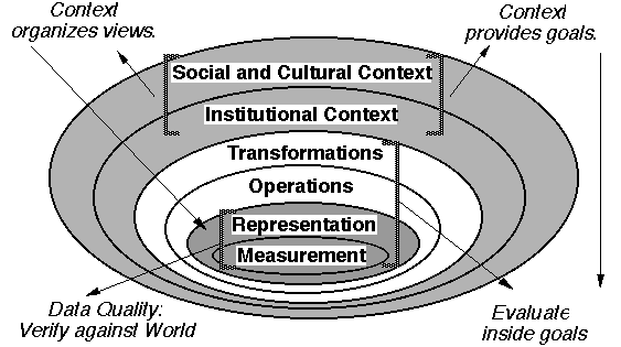
"Geographic Information System (GIS): Organized activity by which people measure and represent geographic phenomena then transform these representations into other forms while interacting with social structures." (Nicholas Chrisman, 2003) [click for image]
Different ways to think about GIS:
- As maps (static or dynamic)
- As databases
- As spatial analysis
Levels of measurement
| Level | Basic Operations | Examples |
| Nominal | Level of data measurement that is non comparative, usually representing a description or name | Land-use categories |
| Ordinal | Determination of greater, less, or equality; ranked data | (good, better, best) |
| Interval | Determination of equality or difference of interval; addition, subtraction | Temperature in deg C or deg F |
| Ratio | Determination of equality or difference of ratio; addition, subtraction, division | Distance, mass, precipitation |
Common classification methods and how to lie with maps...
Some basics classification methods
- equal interval - each class has the same difference in value
- natural breaks - visual examination, manual determination
- quantile - each class has the same number of units
Example of classification schemes from a student project at Hunter College CUNY
Projections
A map projection is a system by which locations on a curved surface can be displayed on a flat surface. No matter what, there will always be some level of distortion in the angles, areas, directions, shapes or distances.
Types of distortion:
- area - relative areas of mapped projections are not correct
- shape - the shape of a mapped region is not correct
- distance - relative distances between points on the map are not correct
- direction - Compass directions (bearings, azmuths) are not correct
for more information look at Map Projection Overview by Peter H. Dana.
Vector vs Raster
What is vector? - It is an abstraction of the real world in which spatial elements are represented in the form of Points, Lines, and Polygons.
|
advantages
|
disadvantages
|
What is raster? - It is the representation of spatial data as a matrix of cells holding values for an attribute.
|
advantages
|
disadvantages
|
What makes a good map?
This is a very complex question and we will not discuss much on this topic.
However, for our purposes all maps should contain a few basic elements:
a title, the date of creation, source, author, a legend, scale, and a directional arrow (compass rose).