


Introduction
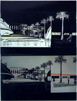
One of the defining characteristics of the Brooklyn Heights Promenade, with its sweeping view of Manhattan and New York Harbor, is it's separation by the High Speed BQE, from the waterfront it overlooks. Moreover, all the access of Brooklyn Heights to this waterfront is very limited. Only Old Fulton Street, Joralemon Street and Atlantic Avenue descend and connect into Furman Street, at the lower level. People from all over the city, region and the world visit the Promenade but cannot access the waterfront.
Action Areas:
Sparking new opportunities by exploiting the existing conditions of separation.
1.Montague Street:
The skyline of Manhattan and the Civic Center are in a strong dialogue with Montague Street as a transmitter. In addition there are various simultaneous intentions of activities (residential, day time users, tourists, visitors) and several types of traffic (delivery, trucks, taxis, tour-buses) on Montague Street. This street is also the major access point to the Brooklyn Heights Promenade.
Bridge the difference in altitude between Montague Street and the East River by: Extending Montague Street down to the East River and the waterfront. Cafes, restaurants, a club, a bookstore and stores (such as a bakery, deli) are the physical opportunities arranged along the path, attracting and guiding the public to the waterfront.
2. Old Fulton Street: Intersecting Old Fulton Street is a regional highway (BQE), a metropolitan conduit (Brooklyn Bridge), and a local thoroughfare (Furman Street). Old Fulton Street is the only street in the study area to terminate at the East River, however, the confluence of the roadways has resulted in the total domination of the street by the automobile.
Revitalize of Old Fulton Street allowing residents and visitors from local, metropolitan, regional and global to experience the water-edge at Old Fulton Street by: Re-establishing the existing ferry landing with connections to Manhattan (South Street Seaport), Governors Island , New Jersey (Liberty State Park) and the Bronx (Yankee Stadium). Creating new functions along the street for both tourists as visitors and residents. Providing nature as a link to the water.
3. Furman Street: As a bypass to the congestion of Brooklyn Heights, Furman Street operates sufficiently. However, due to its proximity to the river and its parallel relationship to (although separated from) the Brooklyn Heights Promenade, Furman Street is full of unused potential.
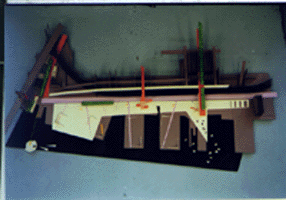
Furman Street is to be transformed into a Boulevard and changed from local to metropolitan scale, relieving the congestion on Montague Street by:
Widening the lanes to facilitate a more leisurely pace. Introducing an "action station" path along the Boulevard providing pedestrians with recreation, relaxation, and social contact. Recognizing the Brooklyn Bridge as a point of reference, or icon, at the terminus of the axis. Establishing a new relationship between 3 scales of speed:
Promenade walking talking 360 degrees 4 mph
Boulevard cruising see and be see 180 degrees 15 mph
BQE driving point to point 2 degrees 65 mph