|
URBAN RESEARCH: PROBES
Urban Condition:
|
|
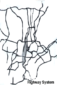
The North Park Highway system, entering the city, has been slowed down and turned into a local highway system continuing southward through to Battery Park.
|
Houston Street connecting East to West is abruptly slowed down just before the West Side Highway and the continuity of its flow is broken. The pedestrian speed along the waterfront, then, is stopped in order to yield cars coming from Houston Street onto the West Side Highway.
|
|
Between 42nd Street and 34th Street, the destination of the city is hidden by the great actor, the Javits Convention Center. Also around this area scattered activities and high speed traffic block pedestrain access to waterfront.
Urban Strategy and Programmatic Response: To suggest the existing movement patterns within the site by articulating the movements of pedestrians and vehicule. From the South, the existing recreational promenade will continue as it is currently used, passing the conflict area of Houston Street and connecting to the abandoned railroad at 14th Street. The new activated railroad will move through Chelsea Piers and continue on to the Convention Center.
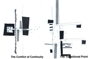
Different patterns of speed generate various activities within the existing conditions. To stop, start, and trade these various speeds two different areas are explored. One is the density of the local speed area between the 14th Street and Battery Park and the other is the transitional point of movement through the city, from 42nd Street to 34th Street.
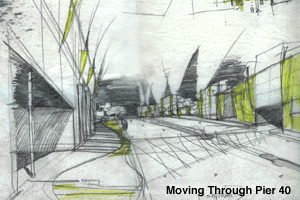
PROBE 1/The Density of Speed Differences: Local Scale Condition at Pier 40 between Canal Street to Christopher Street.
|
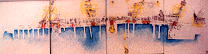
To break the barrier of the highway, a connecting bridge is proposed from the ground-level of the St. John Building to Pier 40 . The existing pedestrian walkway in front of Pier 40 will be elevated and separated into two paths so that the recreational speed can continue unhindered, to interact smoothly with the building that will become a movement exchange area. The existing parking structure at Pier 40 will be renovated to a multi-use building for parking. A public recreational area will be created to facilitate the continuity of movement.
|

|
Programming of Pier 40: Parking Market Place Open Space RecreationOutdoor Theater
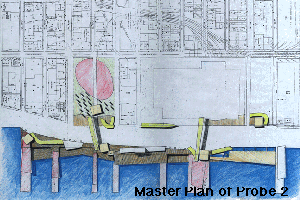
PROBE 2/The Transitional Point of the Moving Through the Edge City: Metropolitan Scale Condition between 42nd Street and 34th Street.
|
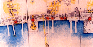
To enhance movement in this area, a sense of "gateway" will be created to help make transition linkages at various scales; train, ferry, and bus. The waterfront edge might increase its use as a tourist area. To intensify the life of the area, some now distant activities will be moved closer so connections can be made more easily. There are also two proposed pedestrian bridges to link across the highway. One will be located at 42nd Street and the other at Javits Convention Center. A parking area on the edge of 42nd Street is also proposed to support the interchange of activities at this destination.
|
Programming of the Area: Parking Ferry Terminal Waterfront Promenade Helicopter Port
For comments about the project write to: [email protected]
For comments about the home page write to: [email protected]