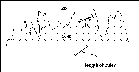
Figure 5.1.1
Introduction to Earth Sciences I
5.1 The Coastline Problem - Order underlying disorder
Look at a coastline. Many processes combine to form the land/water interface - water, erosion, wind erosion, rock type (hard or soft), earlier history of Earth movements, human activity. In fact, it is presently estimated that human activity has a larger affect on shaping the Earth's surface than any other single process. In general, as I drive along a coastal highway, the road that I have passed over gives me little or no clue as to what I am going to find around the next corner - I can't predict the coastline.
So how do I learn about the coastline - forming process ? I could go find an element of coastline that I deem to be "typical" of the coastline as a whole, study it in detail, and extrapolate what I have learned to the entire coastline. This reductionist approach is not entirely without merit, but I will assert that it is very limited because the inherent unpredictability of the system makes the extrapolation uncertain.
Let's take a different approach. I will guess that the total length of a coastline is an indicator of the process - highly irregular coastlines are probably formed by a different process than smooth regular ones. Classic geomorphology texts describe a systematic and taxonomy of coastlines. We then need to measure the length. As soon as we do we get into deep trouble. The problem is that the length of the coastline is going to vary with the length of the device you use to measure it.
If a coastline were very rugged and I measure its length with a long ruler (on a map for instance) the answer is going to be incorrect - I will underestimate coastline length.
Along some parts of the coastline (a) I do well, at others (b) I do poorly.
The answer, of course, is to get a smaller ruler. The smaller the ruler the better the estimate. In fact, what happens is the smaller the ruler the longer the coastline.
In fact, coastlines are usually assessed by grid counting.
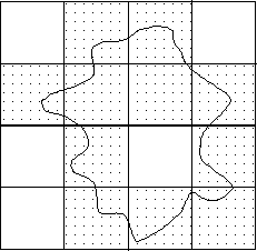
Figure 5.1.2
11 square have elements of coastline in them
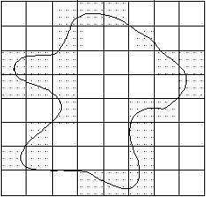
Figure 5.1.3
Then halve the size of the boxes and 25 squares have coastline contained within.
It is obvious that the smaller the grid we make, the more coastline elements will fall in the grids. Just like the ruler - the smaller the device you use for making the measurement, the longer the coastline will appear.
I think that this is pretty obvious and doesn't lead to any special insight into coastline - forming processes.
What is not intuitive is that there is often a very regular relationship between coastline lengths obtained from different measuring lengths. If we display this information on the special type of plot that we used for earthquakes coastline lengths appear to have an internal relationship.
The real example of the Deer Island coastline shows that in this practical case there is an internal relationship in the coastline dimensionality.
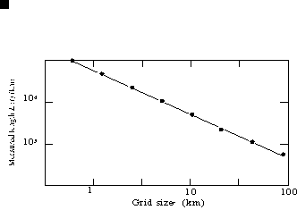
Figure 5.1.4
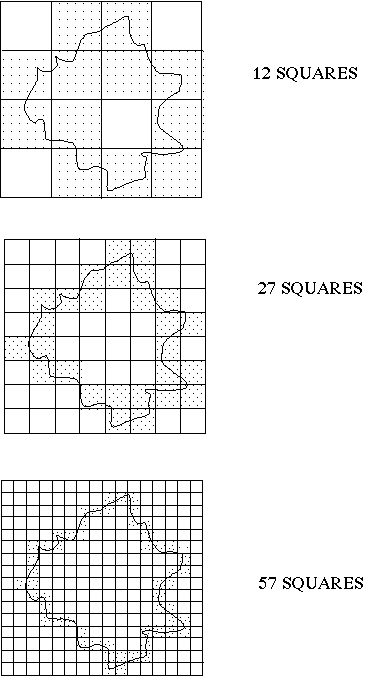
Figure 5.1.5
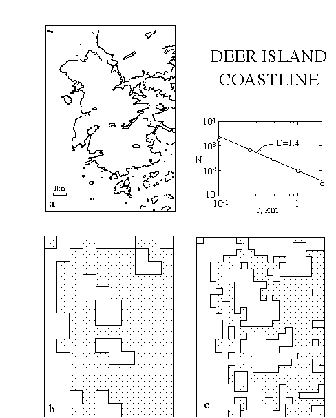
Figure 5.1.6
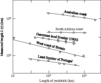
Figure 5.1.7
The coastlines of different countries as well as their internal boarders have different shapes, this leads to different slopes.
This would seem to imply that there is some sort of underlying regularity embedded inside this irregular, unpredictable system. The phenomenon is akin to the size ordering of sand pile avalanches despite the unpredictability of the avalanches, earthquake magnitude, etc. It is this embedded ordering that gives promise of predictability.
The regularity that exists inside this system is called SELF-SIMILARITY and it is one of the most natural properties of all Earth systems and is certainly present in the coastline-forming process. Self-similarity will be discussed in more detail below.