WORLD, 977
WORLD, 977
The world, centering on the Persian Gulf, by Abu Ishaq Ibrahim
ibn Muhammad al-Farisi al-Istakhri,
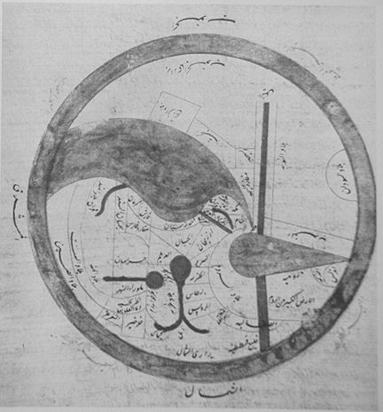
c.977 CE: his south-north map, and a north-south schematic
diagram of it;
*a version from c.934*
Source: http://gate.henry-davis.com/MAPS/EMwebpages/EML.html
(downloaded July 2006)
"Al-lstakhri was virtually unknown apart from his one work. He does not appear in any of the standard Arab biographies, and all we know about him personally was his meeting with Ibn Hawqal (Slide #213) [943-969], which is related in the latter's own book. Even his work Kitab al-masalik wa-al-mamalik can be dated only from internal evidence, to the middle of the 10th century A.D. It soon became popular, however, for there are many early editions, abridgments, and translations into Persian, often differing considerably from each other.
In the Balkhi-Istakhri-Ibn Hawqal set of writings, there are four distinct recensions of what is basically one set of maps. For these this monograph shall follow Kramers's example and call the four types Istakhri I, Istakhri II, Ibn Hawqal I, and Ibn Hawqal III. The manuscripts of Ibn Hawqal III, though all undated, are much later than the other texts, probably from the late 13th or early 14th century A.D. The regional maps are nevertheless copies of the earlier versions. The world map of Ibn Hawqal III, however, is so different from the other world maps that it warrants special consideration.
The maps accompanying the geographical texts from what is termed the "Balkhi School" of geography, seem at first sight to be a not necessary supplement to the texts, the text being so complete in itself. This is often so with illustrative material in classical Arab texts, certainly with maps in some later geographical works. This set in most cases comprises twenty-one maps, although some manuscripts lack a map or so. The consistency with which the same set of maps appears in so many manuscripts and with several different authors led Konrad Miller to call the set the "Islam-atlas," and it has been called this by several other scholars. The set consists of a world map, maps of the three seas-the Mediterranean, the Persian Sea (Indian Ocean), and the Caspian Sea-and maps of seventeen "provinces" of the Islamic empire. The word "provinces" is placed in quotation marks because in some cases provinces are linked together in one map (Azerbaijan, Armenia, etc., and Spain and the Maghreb) and because the Persian Desert is hardly a province. The word the texts use for "province" is iqlim, from the Greek word that reaches Arabic through the translation of Ptolemy. The word was used first to translate the Persian kishvar, which was a specific geographical region, and hence comes the present usage. A complete list of these maps in the order usually found in a manuscript is as follows:
(1) world map;
(2) Arabia;
(3) Indian Ocean;
(4) al-Maghrib [North Africa];
(5) Egypt;
(6) Syria;
(7) Mediterranean Sea;
(8) al-Jazirah [Upper Mesopotamia];
(9) Iraq (Lower Mesopotamia);
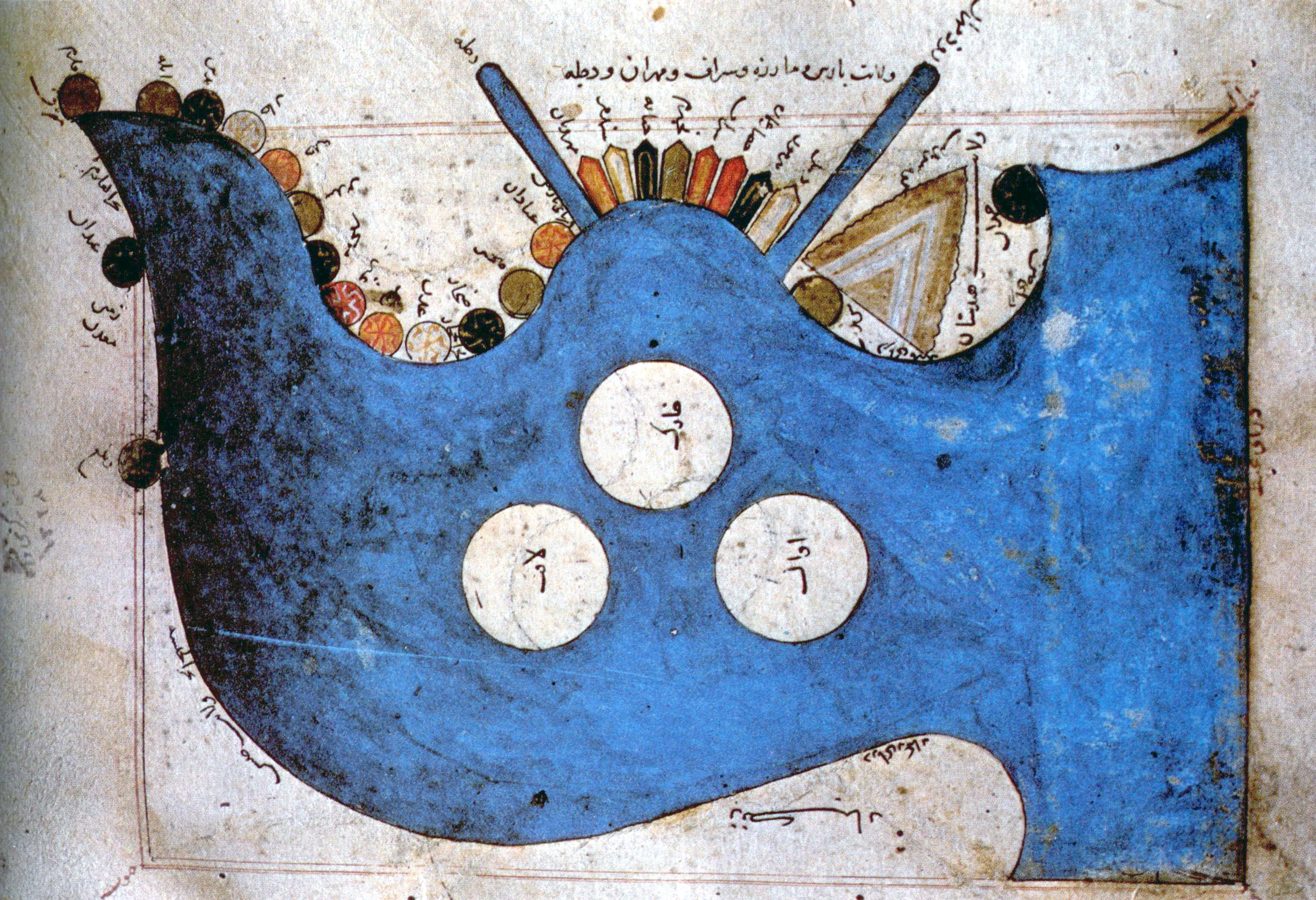
(10) Khuzistan;
(11) Fars;
(12) Kirman;
(13) Sind;
(14) Armenia, Arran (Alvan), and Azerbaijan;
(15) Jibal (central Persian mountains);
(16) Daylam and its neighbors (Rayy, Tabaristan);
(17) Caspian Sea;
(18) Persian Desert;
(19) Sijistan;
(20) Khurasan;
(21) Transoxiana.
The thirteen maps that represent the Persian-speaking provinces of the Islamic empire are fairly consistent in form throughout all the manuscripts. Their form was stereotyped by the time of the first al-Istakhri recension, and Ibn Hawqal seems to have found no need to change these maps. Even Azerbaijan and al-Jazirah, of which Ibn Hawqal produced good versions approved by al-lstakhri, do not seem to have changed much through Islamic Cartography the recensions. It is therefore appropriate to describe these maps of the Iranian area and then use them as a standard for the rest of the set.
The maps of each of these regions consist of an area that is roughly rectangular and usually, although not always, surrounded by a line representing its boundary with the surrounding areas. There is no projection to form the base of the map. The maps cannot be joined together as a multi-sheet map like the sectional maps of al-Idrisi (Slide #219). Even if they are reduced to the same scale, this cannot be done as it can for the sectional maps of the European edition of Ptolemy. The maps are thus individual entities and are seen as such by the draftsman.
This set of maps does not cover the whole world as do the sectional maps of al-Idrisi that follow in the 12th century and the texts of the earlier geographers like Ibn al-Faqih or Ibn Khurradadhbih. These latter include considerable detail on China and India and give some account of Africa and Europe. The Balkhi maps specifically cover the Islamic empire as it appeared in the 10th century. Even Spain has no separate map and is omitted in the text, though it was Muslim at the time. It was, of course, never part of the Abbasid Empire. Inside the Dar al-Islam each province is then given its own map and a description that forms an individual chapter dealing systematically with towns, rivers, mountains, and inhabitants, followed by itineraries throughout the province. S. Maqbul Ahmad has a theory that this Islamicization of the maps and geography was a deliberate policy developing away from the work of the earlier al-Ma'mun type of geographer, which, based mainly on Ptolemy, covered the whole of the known world.
Besides this policy of portraying only the areas of the Abbasid caliphate at its greatest extent, it is further obvious that there is a bias toward things Iranian: so much so that Kramers has suggested there may have been old Iranian maps that are the basis of these Balkhi maps. There is no evidence for the existence of the former, but the maps may ultimately be based on early lists of postal routes surviving from Sassanid times. These lists may perhaps also be seen as the origin of the lists of Islamic postal routes found in the works of the al-Masalik waal-mamalik type. The Iranian bias also appears in the contents of the set of maps. The Iranian area is divided systematically into areas for mapping, whereas the areas the Arabs conquered from the Byzantines were treated in a much less systematic way. This may, however, reflect the administrative situation in the two empires that preceded the Islamic empire at the time when the Arab conquest took place. Al-Balkhi and al-lstakhri were both patronized by the Samanid rulers of Persia, and the emphasis is very much on the Iranian area.
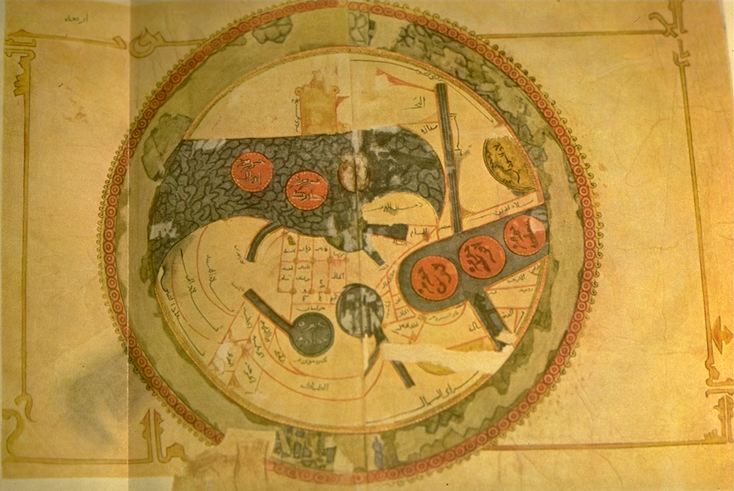
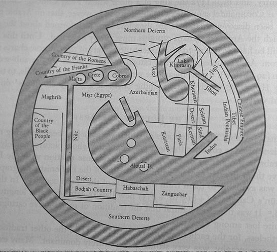
The world map (al-Istakhri I/II and Hawqal III) and the map of the Indian Ocean, which is enlarged from it and always referred to as the Persian Sea, are a different proposition. These two maps are built up by what might be called academic conjecture-an armchair attempt to see all the provinces set down relative to each other. The whole has to fit into a stereotyped idea of what the whole world should look like. According to Arab geographical theory based entirely on Ptolemy, this would be a sphere. Since the far side of a world sphere (an upside-down world) was practically inconceivable, only a hemisphere was thought to be inhabitable. This could easily be "projected" onto a flat area and represented by a circle. That Ptolemy represented the inhabitable world as occupying 180 degrees of the earth supported this idea. Thus al-lstakhri represented the world as a circle surrounded by the Encompassing Sea, with the two main seas reaching in from the east and the west toward the center, where they would join except for a small, narrow land barrier -- the barzakh of the Qur'an .
In his text, al-lstakhri gives a simple description of the world to explain his map. "The earth is divided into two by the two seas, so that we have a north or cold half and a south or hot half. People in these two halves get blacker as you go south and whiter as you go north etc." The main kingdoms are listed together with the kingdoms that adjoin them. This is the only place where non-Islamic areas are given any mention. Measurements are attempted; thus the width from the Encircling Ocean in north-western Africa to the ocean in China was 400 days' journey. However, the distance north to south was not measurable. There were 210 days' journey through inhabitable lands, but the extreme north was uninhabited because of intense cold and the extreme south because of intense heat. The seas were described briefly, and the fact that the Khazar [Caspian] Sea and the Khwarazm [Aral] Sea were landlocked is mentioned, as well as the sea connection between the Encircling Ocean and Istanbul-that is, the Baltic joins up to the Bosporus.
The map of the Persian Sea is an enlarged version of a portion of the world map, although there are enough differences in the shape of the ocean in the two maps to necessitate some explanation. Three large islands, Kharak, Awal [Bahrain], and Laft [Qishm Island], are set symmetrically in what is the Arabian Sea, with the Tigris to the left and the Indus to the right. India and China coalesce into one narrow peninsula, matching Arabia on the other side. The attempt is probably to match the Mediterranean on the other side of the world. Hence India also has a large mountain (Adam's Peak) to match the Jabal al-Qilal near the Strait of Gibraltar. This is the Indian Ocean map in the first recension (Istakhri I).
The second (Istakhri II) is not so symmetrical, and the mountain and three islands become much smaller (as they also do in the Mediterranean). In the world map, the islands disappear altogether in the second recension but are there, very large, in the first. There is no "mountain" in either recension of the world map. The surprising difference is that the western tip of the Indian Ocean, which represents the Red Sea (Sea of Qulzum), points to the west in the ocean map, but in the world map it turns back on itself to almost touch the southeastern corner of the Mediterranean Sea.
Al-lstakhri and Ibn Hawqal show no interest in projections or mathematical astronomy. Neither do they mention longitude and latitude in any form, or any sort of map construction. They both give distances between places on their routes (marhalah = day's journey), and they add these up roughly to give the dimensions of the inhabited world. These distances are not recognizable on the map, however. It therefore does not seem that the authors envisaged any kind of formal scale at all in constructing these maps.
Each map consists of a set of geometric configurations. Though some are more geometric than others, most lines are straight or arced, rivers are wide parallel lines, and lakes are often perfect circles. Towns are sometimes squares, circles, or four-pointed stars or, if they are stopping places on a straight route, resemble small tents or perhaps doors to caravansaries. Thus much of the drafting is ruled with either a straight or a curved edge. The only exceptions are mountains, which are drawn as a collection of peaks or perhaps piles of rocks, though even here the base, which probably represents the position of the range on the map, is a straight line or a regular curve.
The basic purpose of the maps (especially those of the Persian-speaking areas) seems to be to incorporate the caravan routes across the province, with all the stages marked. This is most noticeable on the map of the Khurasan Desert, where the boundary of the desert is given with the bordering villages and oases marked around it. Straight lines then join those places on opposite sides where traffic flows, and the name of the route is written on the line so drawn.
LOCATION: Biblioteca Universitaria di Bologna, Cod. 3521, fol. 2r.
Bibliothek der Rijksuniversiteit, MS. Or. 3101, pp. 4-5, Leiden.
REFERENCES:
Harley, J.B., The History of Cartography, Volume Two, pp. 112-115,
121-22,
127, Figures 5.3, 5.15, Plate 7 (color).
Kramers, J.H., "La question Balkhi-Istahri-Ibn Hawkal et l'Atlas de
l'Islam", Acta Orientalia 10 (1932): 9-30.
Source: http://gate.henry-davis.com/MAPS/EMwebpages/EML.html
(downloaded July 2006)
== Medieval index == Main map index == Glossary == FWP's main page