

|
by Joseph Brennan. Copyright 2001, 2002. |
Bowery platformPassenger service: August 1913 - September 2004. Existing abandoned portions: The present south platform is scheduled to be abandoned but is still open at this time. This is the platform now used by J M Z trains running toward the Williamsburg Bridge. Touring: J M Z trains to Bowery. The platform is open at this time. construction and operationThe history of Bowery station is similar to that of Canal St, the next station down the line. They are on the Brooklyn loop line built to bring trains from the Williamsburg Bridge to lower Manhattan. The section around Bowery station was begun in August 1907 and was almost complete at the end of 1910. The line did not open until August 1913, when the Chambers St terminal was ready. Work at the Bowery was delayed by real estate acquisition for the "Delancey St Extension", eventually named Kenmare St. Delancey St was an old street that was greatly widened as an approach to the Williamsburg Bridge, which opened in 1903, but it ended at the Bowery. The subway needed to continue west to Centre St. The city bought the necessary property through four blocks and opened it as a street after the subway was roofed over. Where the subway turns under private property into Centre St, the block was built on afterwards. Bowery was an important street. It had four streetcar tracks, a pair each for the Madison Ave (New York and Harlem) and 3 Ave lines. The 3 Ave El ran overhead, still on two single track structures at the curb line in 1910, but because it was built long before the bridge (1878), the nearest station was two blocks south at Grand St, and there was not an easy transfer with the subway. The subway station has two island platforms, so all trains can stop.
As a result of the provision for an unbuilt subway, the station has two mezzanine areas, on each side of the Bowery. The one on the east side came up to a building at street level in the center mall of Delancey St, known as the Schiff Parkway. The one on the west came up into buildings on the north and south sides of the new street being built, now Kenmare St. The west mezzanine is now closed. Probably because of the depth, escalators were provided for in the original construction, one on each platform running to the east mezzanine. The escalator on the south platform was either not installed, or removed long ago. There would have been relatively fewer passengers leaving the station from the south platform, since trains arriving on that side would have started only at Chambers St. Bowery has long been one of the least used stations on the transit system. Subway historian Joe Cunningham has pointed out that the steps still have the original metal treads, which have long since been replaced at all the other stations. The name of the Bowery has been synonymous with Skid Row since the 1930's, and it has not been a strong location for residential or business transit use. In addition, riders to and from the area seem to prefer stations on lines with better connections. The south or east platform was taken out of service in September 2004. Trains running toward the Williamsburgh Bridge were rerouted into the former "inbound express" track so that the north or west platform now handles trains in both directions. The photos below show the station in August 2001 while the now-closed platform was still open. |
diagram
Bowery station itself is very simple and symmetrical. Just to the east of the station, a branch of the Chrystie St subway (opened in 1967) crosses over, not shown, and east of that, another branch joins the old subway at about J57. Essex St station, just past the end of the Williamsburg Bridge, was rebuilt in connection with the subway through Bowery station, but not to a full four track station. |
|
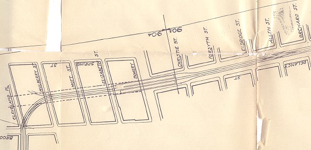
A detail of a Public Service Commission map shows the station location, including the private property west of Bowery. At the curve is a provision for a branch into Spring St, for which no definite plan was ever provided. Public Service Commission for the First District, from their Report. . . for the year ending December 31, 1908, Albany: the Commission, 1909. |

|
Bowery station is richly documented in two volumes of the Report of the Public Service Commission for the First District. Since the originals are scarce and are rapidly deteriorating, more than usual are shown below. Photographs: Report. . . for the year ending December 31, 1908, Albany: the Commission, 1909. Plans: Report. . . for the year ending December 31, 1910, Albany: the Commission, 1911.
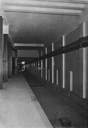
This view is from the stairs looking west down the south platform. The escalator would have dropped down just ahead where the three pairs of columns are closer together. In the distance is the stairway up to the closed west mezzanine. The wall at right is the dividing wall between the center tracks.
|
|
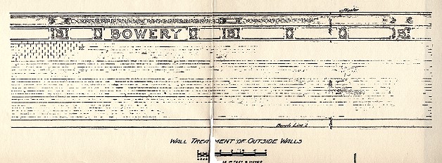
Top, again looking west along the south platform, showing the south side wall. Bottom, detail of the 1908 plan for side wall decoration.
 Above, looking east along the south platform, showing the center wall, and the stairs to the open east mezzanine. Left, the center wall from one of the platforms, seen in 1910 before track was laid. Below, detail of the 1908 plan for center wall decoration. At some date since construction, the steel columns have acquired concrete protection around their bases. |
|
|
|
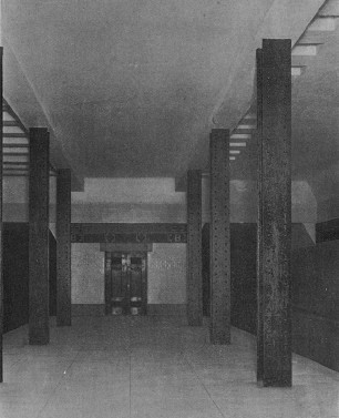
The west end of the north platform, seen in 1910. |

|
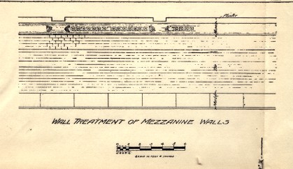
Top, 1908 plan for tiling in the mezzanine levels. Bottom, a detail from a photo by Wayne Whitehorne shows the mezzanine tiling today. Lower photo copyright 1998 by Wayne Whitehorne. From http://www.nycsubway.org/bmt/bwaybkln/ at the New York Subway Resources site.
|
|
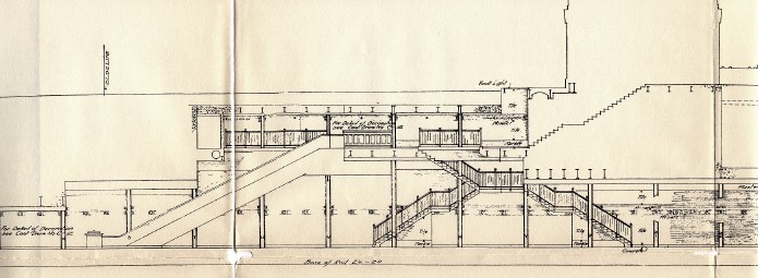
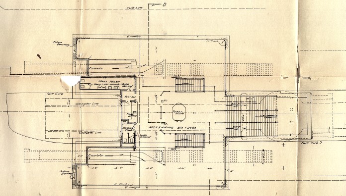
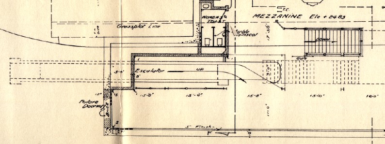
Above, a cross-section, elevation, and plan of the open east mezzanine from 1908. The elevation and plan have east (Williamsburg Bridge) on the right, and show the building in the center mall of Delancey St. Below, a detail from the plan shows the escalator from the south side platform. It also shows the notation "Future Doorway" where an opening could be made to the never-built Bowery subway station, if it had side platforms. |
|
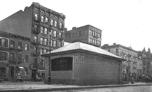
The station building in the center mall, seen in 1910, turns its back on the Bowery. 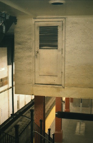
Watch that first step! Seen from the stairway to the north platform looking west, the control room for the escalator has a remarkably ordinary looking door with an ordinary knob. No such room now exists on the south platform. |
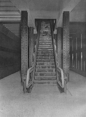 Seen in 1910, the escalator on the north platform is almost complete. The wall at right is the wall between the center tracks. |
|
|

|
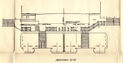
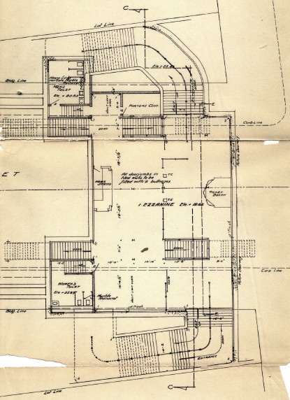
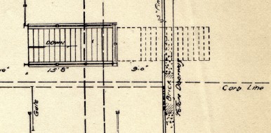
Above, a cross-section, elevation, and plan of the closed west mezzanine from 1908. The stairways go up to entrances in buildings on the sides of what is now Kenmare St, which is narrower than Delancey St and has no center mall. (All at the same scale as the east mezzanine images above.) A detail of the plan again shows the "Future Doorway" to the never-built Bowery subway. |

|
|
|