|
|
by Joseph Brennan. Copyright 2001, 2002. |
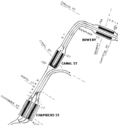
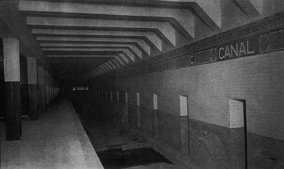
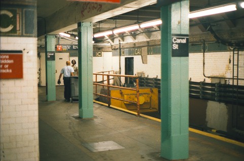
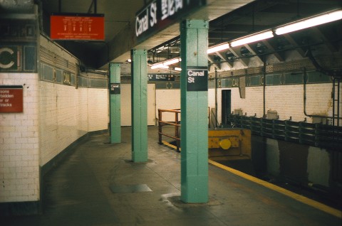
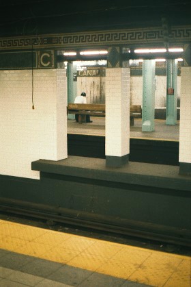
Canal St platformPassenger service: August 1913 - September 2004. Existing abandoned portions: The east side platform. Touring: J M Z trains to Canal St, or transfer from N R Q W 6 trains at Canal St. The platform is open at this time. construction and operationThe Board of Rapid Transit Railroad Commissioners, fresh off the success of the first subway, planned the Centre St Subway, originally the Brooklyn loop line, to connect the elevated or subway tracks under construction on the Williamsburg Bridge and Manhattan Bridge to a terminal at Chambers St, the end of the Brooklyn Bridge. Construction began in May to August 1907 on the several sections. The route was mostly built using re-enforced concrete, not the steel beam construction seen on most earlier and later subways, and it has walls between the trackways, intended to promote air flow resulting from train movement. After the Public Service Commission for the First District took over subway planning in July 1907, they redesigned the Brooklyn loop. It had originally two doubledeck stations located at Leonard to Franklin Sts and at Howard to Grand Sts, with grades up to 5% in and out of the doubledeck stations. The Commission changed it to one level throughout, and replaced the two stations with one located at Canal St. The new plan was simpler, provided a connection with the new subway planned in Canal St coming off the Manhattan Bridge, and had better grades. The size of the tunnels was increased to allow for larger cars than the IRT operated. Canal St station was "practically completed" at the end of 1909, including the bridge over the proposed Canal St subway to cross underneath. (The Canal St subway was built and is now the route of the Q W trains.) Delayed by construction of the Chambers St station, the Centre St subway opened in August 1913. The original design of Canal St station was that of a typical express station as on the first subway, with four tracks and two island platforms. Only the west two tracks and west platform were used until September 1914. At that time, the northbound track was relocated south of the station, so as to swing over to the easternmost side of Canal St station, and the south end of the station was rebuilt into the present plan. The center pair of tracks end in the station, and a walkway connects the two platforms, running across the original trackways of the center tracks running south. A wall blocks what would be a view of the tunnel south to Chambers St. For reasons unknown, the east and west platforms were finished differently. The west platform has tiled columns like Chambers St, while the east platform has bare steel columns like Bowery. The west platform had access up to street entrances in buildings on both sides of Canal St, while the east platform had an underpass to a third building on the northeast corner of Canal St. Both platforms got stairs down to the new Broadway subway crossing under in Canal St when it opened in 1917. The platforms were extended northward in 1924. Canal St was a very busy station in the past. The once-dense population along the Broadway El in northern Brooklyn required a very intensive train service, which terminated about half and half at Canal St and Chambers St. Canal St was a reasonable terminal because many passengers transferred to the Broadway subway line. Many passengers from the Canarsie branch and some passengers from streetcars were diverted to the 14 St subway (L train) when it was completed in 1928. The depopulation of north Brooklyn in the 1960's led to service cuts, and by 1968 only a few rush hour runs terminated at Canal St, on the eastern center track. From July 1, 1968, the extra rush hour trains were diverted into the Sixth Ave subway by a new connection (itself now closed since 1976), and no more trains terminated here. The western center track was disconnected but left in place for many years. Under plans announced in 1999, the eastern pair of tracks were to be taken out of service, in a virtual restoration of 1913 operations, and the south end of the station is to be opened up so the northbound track can again run almost straight to the western platform. Because of this, only the west platform was renovated, and they presented quite a contrast in appearance. The south end was opened up in 2003 and the new plan was put into effect on September 20, 2004. The photos below show the station in August 2001 while the now-closed platform was still open. The openings in the center wall have been closed up and of course the south end now looks quite different. |
diagram
The diagram shows how the four track subway south of the station consists of two double track routes side by side. The Manhattan Bridge connection was cut in 1967 but the tracks remained for car storage for many years. The disconnected center track at Canal St was lifted in the 1990's. |
|
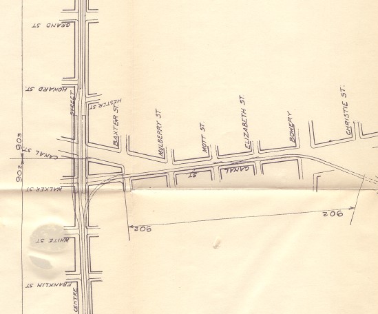
A detail of a Public Service Commission map shows the station location and the branch to the Manhattan Bridge. This plan from 1908 shows all the tracks running through Canal St to Chambers St, not the final track layout as operated. Four tracks were constructed off the Manhattan Bridge and across Canal St. The pair not shown run along the north side of the pair shown, and curve off at Mulberry St to continue down the center of Canal St to Broadway. The present route of the Q W trains follows the tracks shown from the bridge to the location of the switches shown, between Elizabeth St and Mott St, where it crosses over to the northern pair of tracks (not shown). Public Service Commission for the First District, from their Report. . . for the year ending December 31, 1908, Albany: the Commission, 1909. |
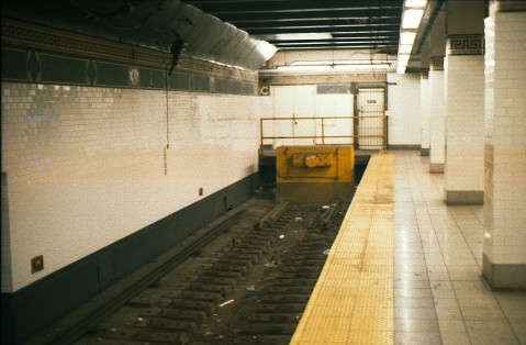
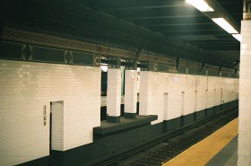
 The deterioration of the east platform has been left as is, pending closing. Nothing like this can be seen on the renovated west side. This is all original tile. Both images show the east wall. |
|
|
|
A Public Service Commission photo from 1909 shows the east platform with non-tiled steel columns. The view is looking south, showing the wall between the center tracks. The stepped structure at the base of wall near the image center is part of the bridge over the projected Canal St subway, not even begun at the time. The station looks completed, about four years before it opened. There is a rough strip near the platform edge. Track was to be installed by the operating company. Public Service Commission for the First District, from their Report. . . for the year ending December 31, 1909, Albany: the Commission, 1910. 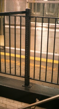
On the closed platform, the railings of the stairway down to the Broadway subway have posts identical to those at the Nevins St station underpass, installed probably in 1908. |
|
|
|
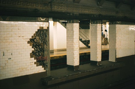
There's an opening in the center wall about fifty feet from the end of track. It has a narrow platform on it. According to subway historian Joe Cunningham, it was used by train crews to cross between trains on the center tracks. The position would be at the end of the first car from the bumper. Seen through the opening is the renovated west platform. In the recent renovations, new tile has been placed on the columns and the sides of the openings, except on the side facing the east platform. The difference is not as clear in this image as it is in reality, but the missing wall tile can be seen. 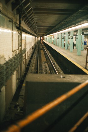
This is the view from the bumper, looking north along the east platform center track. |
|
|
|
The series above show the walk across the south end of the station. Behind the slanted wall (top image), the northbound track curves across the tunnel to where the west side center track (bottom image) would run if continued straight. The same white door can be seen in the end wall in the middle and lower images, to the right of a tiled "C". The leftover space where the tracks once ran has been filled with equipment rooms that will need to be relocated for the planned track realignment. The original difference between tiled and untiled columns is heightened by the new floor and lighting and replacement white tiles (which are laid directly over the old). 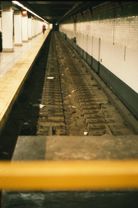 This is the view from the bumper, looking north along the west platform center track, which has been lifted. Contrast to the east side, above. The last rail segments are built into the bumper and were too difficult to lift. Three ties past the end of the rail on the right, note the fixed (not movable) trip that would have thrown the brakes on a train that came any closer to the bumper. Down the wall on the right, note the platform edge of the wall opening mentioned above, and a little farther, the stepped structure marking the location of the bridge over the subway crossing underneath. |
|
 The opening in the center wall presents a much neater appearance from the west side, although it gives a view through to the comparatively ugly east side. Once the east side is closed, will this remain to provide a view to the abandoned platform? If not, why was it not closed during renovations? |
|
|
|
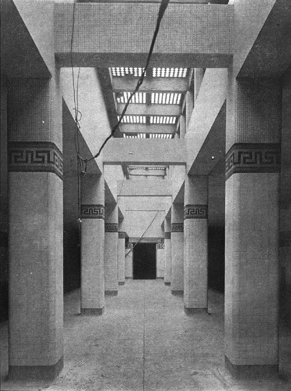
A stunning photograph from 1909 shows the north end of the west platform. Besides the tiled columns, it also shows light coming through from glass tile in the sidewalk, much as it did in many stations of the original subway. Reference to the Public Service Commission plan above shows that the west platform is located partly under the sidewalk, unlike the east platform. Above the tile frieze, the columns and possibly other surfaces have very small tile. Some of this small tile can still be seen on the east wall of the east platform. See the top photo image here. Public Service Commission for the First District, from their Report. . . for the year ending December 31, 1909, Albany: the Commission, 1910. |
|
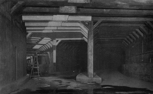
Another Public Service Commission image shows the tunnel just south of the station as it was in 1909. Here, as in the plan, the trackways curving in from the Manhattan Bridge line, right, just run into the main line on the level. At left is the track opening into the east track of Canal St station. This arrangement was rebuilt in 1913-1914, shifting the track to Canal St station a little farther back, so that when the Manhattan Bridge trains began running in 1915, they reached the east side of Chambers St without crossing the tracks of the Williamsburg Bridge trains. Public Service Commission for the First District, from their Report. . . for the year ending December 31, 1909, Albany: the Commission, 1910. |
|
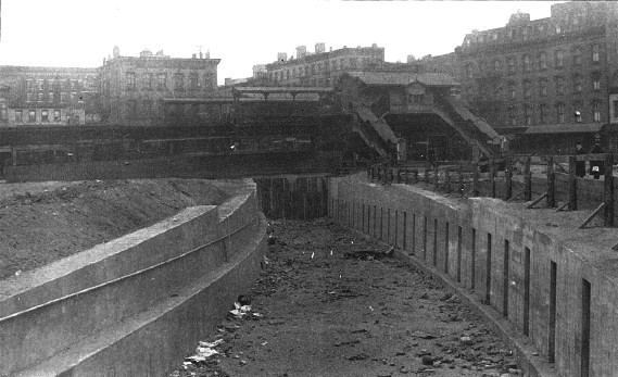
Slightly off topic, here we are in 1909 with the Manhattan Bridge behind us and up ahead, the trackways for the south bridge tracks running down to the tunnel that will bring them to Chambers St. The Q W trains run in these trackways today. The bridge plaza was soon to be built covering this. Crossing left to right is the 3 Ave El's Canal St station. At this location, the el ran on two separate one-track structures on each side of the Bowery, to be replaced in 1914 by a newer structure spanning the street. Public Service Commission for the First District, from their Report. . . for the year ending December 31, 1909, Albany: the Commission, 1910. |

|
|
|
![]()