|
|
by Joseph Brennan. Copyright 2001, 2002. |
Kresge'sPassenger service: Jan 1927 - May 1938 (end of rail service) - 1966?Existing abandoned portions: 1 platform on an abandoned trackway. Touring: Not visible. McCrory'sPassenger service: Aug 1929 - May 1938 (end of rail service) - 1966?Existing abandoned portions: 1 platform on an abandoned trackway, walled up. Touring: Not visible. construction and operationThe Cedar St subway was constructed in 1914-1916 by the Public Service Railway to bring streetcars into the lower level of the new Public Service Terminal in downtown Newark. The portal is in private property between Washington St and Halsey St, and the tunnel runs mostly under Cedar St, which is just one block long, and then across Broad St and the point of Military Park. The large Public Service Terminal filled the block between Park St and Mulberry St on the north side of Raymond Blvd. The public entered at street level, and reached the cars by going up or down to the two terminal levels. The upper level, reached by ramp from Mulberry St, was always much the busier of the two. The terminal and the Cedar St subway opened in April 1916. The upper level saw 2,050 cars a day, and the lower 550 cars a day, in 1916, with more than 50,000 fares paid. Broad St was the major shopping street of Newark. In 1926, the Kresge's store at the southwest corner of Broad and Cedar arranged to have a platform opened in the subway at its basement level, allowing customers to come in directly from the subway. The station was opened in January 1927 on the inbound side. The only access was through the store. Kresge's was a general store similar to Woolworth's. The company now operates the Kmart chain. The McCrory's store on the opposite side of Cedar St followed the lead and had another platform opened on the outbound side in August 1929, directly opposite Kresge's. Again, the only access was through the store. Since it was on the outbound side, it must have been used mainly as a store exit. The platforms drew people into the stores just to change cars between routes in the tunnel and routes out on Broad St. They were open of course only during store hours. The following carlines used the Cedar St subway and would therefore have made a stop at Kresge's and McCrory's. Some of these routes ran only rush hour cars or alternate cars to the subway.
The Cedar St subway was closed from February to March 1937 for installation of pavement around the rails. Public Service Coordinated Transport had developed a hybrid All Service Vehicle that could run as a trolleybus and as an off-wire gasoline-electric bus, and began converting its streetcar lines to ASVs. Public Service had the largest fleet of such vehicles in the country. ASV service in the Cedar St subway began when 17 Paterson was converted, if not earlier. Joint car and ASV operation lasted only until May 1938, when 43 Jersey City was converted, ending rail service. Of the routes above, only 17 and 43 used the subway as ASV routes. Operation by ASV continued until 1947. Improvements to diesel engines and transmissions had made the use of electric motors needlessly complex, and the simpler diesel bus rapidly took over the industry after the war. Even this however did not spell the end for the Cedar St subway. It was operated by diesel bus for another nineteen years. The subway finally closed in May 1966, twenty-eight years after the end of rail service. The last bus lines into the subway were 62 Perth Amboy, 128 Paterson, and 134 New Brunswick-- none of them local Newark routes. The closing dates of the Kresge's and McCrory's stations are not known. It is hard to believe they were used with diesel bus service, but they were definitely in use into the ASV period. You walked from the station platform area, all dark and with the subway "fragrance" of ozone, and the sound of the trolleys, through a revolving door and instantly into a world of dazzling light and merchandise, mannequins, vivid colors--like going into another world--quite a thrill for a kid, the first time! -- Al Mankoff Much of the data above is from John Harrington Riley, The Newark City Subway Lines, Oak Ridge NJ: the author, 1987. |
diagram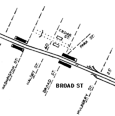
The existing Cedar St subway runs from the portal in the block off Washington St to about the east side of Park St. Cedar St itself runs just from Halsey St to Broad St. Also shown is a portion of the nearby City Subway, and the stubs of its former connection to the Public Service Terminal. The Public Service Terminal building itself was closed in 1978 and was destroyed by explosives in 1981. The Cedar St subway must now end somewhere under Park St. |
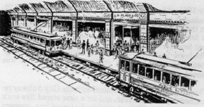
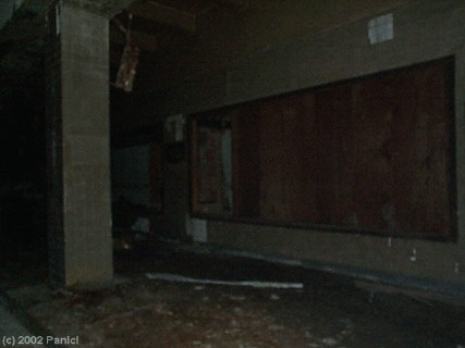
This sketch is supposed to show what the stations in Cedar St looked like. In reality, there were lines of columns between the tracks and near the platform edge. Source unknown, Al Mankoff collection, from A W Mankoff and C D Wrege, Trolley Treasures volume 1, Canton OH: Railhead Publications, 1986, and available online at http://www.almankoff.com. |

NJ Transit gave the press a tour of the tunnel on 17 October 2000, to raise interest in light rail transit in Newark, although they admitted no use of the Cedar St tunnel was foreseen. Mayor Sharpe James, along for the tour, proposed opening it as a shopping mall "just like Underground Atlanta", but mentioned that the city and NJ Transit has not settled "a question of ownership". |
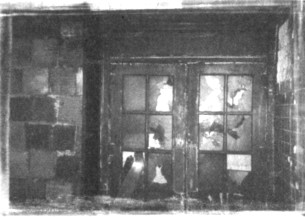
A photo taken in 1996 shows an abandoned doorway in the station. From Weird New Jersey issue 18, 2002. Used by permission. |
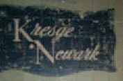
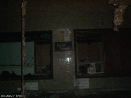
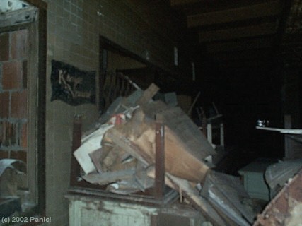
Jason C, also known as Panic!, visited the tunnel in 2002. He reports not seeing the McCrory's platform, but has provided some shots of the Kresge platform for this page. News reports from the press tour in 2000 also mention only the Kresge's side. Photo at left and four below copyright 2002 by Jason C of the former web site urbanadventure.org (removed in 2008). Used by permission. |
|
|
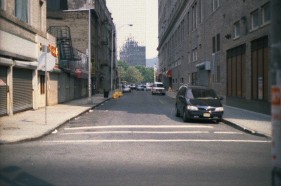
Here is Cedar St today, from Halsey St toward Broad St. Public Service Terminal was straight ahead across the point of Military Park. Its mirror-glassed replacement, just beyond the trees, blends into the sky. Kresge's was on the end of the block on the right, and McCrory's was on the left. |

The owners of the former McCrory's haven't taken down the sign yet, which looks like it will be an expensive proposition. Cedar St ends just in front of it, and the former Kresge's is at the extreme left. |
|
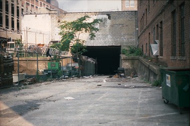
There was a station outside the tunnel in private property just off Washington St. The property has still not been built upon, and tracks can still be seen in the pavement of the vacant lot. 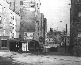
1916. The tunnel has an arched portal that appears to be back at Halsey St. The tall building in the background is the Public Service Terminal. The buildings on the left side of Cedar St are still there today. Stephen D Maguire, from Edward Hamm Jr, The Public Service Trolley Lines in New Jersey, Polo IL: Transportation Trails, 1991. |
1937. A building has been constructed on the west side of Halsey St covering the arched portal and blocking the view down Cedar St. A 43 Jersey City car stops for a passenger. North Jersey Chapter, National Railway Historical Society collection, from Joseph P Saitta, The City Subway - Newark's Best Kept Secret (Traction Extra number 1), Merrick NY: Traction Slides International, 1985. |

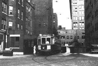
1936. A close-up shows a 17 Paterson car coming out under the building. W Sherwood, from John Harrington Riley, The Newark City Subway Lines, Oak Ridge NJ: the author, 1987. |

1976. Another building "Janet Shops" now covers even more of the tunnel approach, but still does not block the entrance. The concrete retaining walls on both sides are from 1916. Ten years after bus service ended, the fence between the tracks remains and the tracks are still easily seen. |
2001. The former Janet Shops building has become more ugly with the loss of windows, and a chainlink fence with barbed wire now divides the tracks. The tracks are disappearing under debris. |
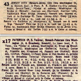
The Cities Map and Guide Company's Guide Book to streets of Newark for 1939 lists two local transit routes as running in Cedar St, the 43 Jersey City car, which actually had been converted to bus in 1938, and the 17 Paterson bus (the guide uses x to designate a bus). The careful notation about stopping at Broad St in the Cedar St subway refers to the Kresge's and McCrory's stations. The 43 car had originated as shown at Penn Station in the City Subway, and run via the connection to Public Service Terminal. Both bus lines were run by All Service Vehicles using trolleybus wire. |
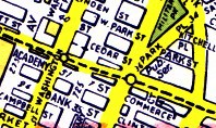
The current Hagstrom map of Essex County still shows the Cedar St subway. Streetcar and bus lines were shown by dashed lines on early editions of the map, and red lines later. The current edition does not show them at all, but there is still a dashed line from Washington St to Halsey St, and the notation "Pub. Ser." remains at the site of the Public Service Terminal. The other dashed line indicates the route of the City Subway. |

Issue 18 of Weird New Jersey, 2002, has a one-page story on the Cedar St Subway, with three photos showing details of the station. If you don't shop at weird stores in New Jersey, you can obtain the magazine from their web site. |
![]()