

|
by Joseph Brennan. Copyright 2001, 2002. |
COMPLETELY REMOVED
Cortlandt St / World Trade CenterPassenger service: First station: July 1918 - September 2001. Second station: not completed. Existing abandoned portions: First station: Completely removed by March 2002. Second station: Shell for platforms. Touring: 1 and 9 trains run through a new tunnel constructed in 2002 that passes through the shell of the new second station. construction and operationThe branch line from Chambers St to South Ferry via Greenwich St was built as part of the Seventh Ave subway, one of the IRT routes of the Dual System announced in 1913. It opened in July 1918. The routing plan is that Seventh Ave locals run by this branch to South Ferry, while Seventh Ave expresses turn off and run to Brooklyn via Park Place and William St. Although it is mostly just a two track line, construction was not simple. The streets are narrow, and buildings already old in 1913 had to be supported along the edges of the excavation. The 9 Ave El ran overhead the length of Greenwich St. At Dey St, about the center of Cortlandt St station, the contractors came across the hull of a ship that burned and sank in colonial times; and under Battery Park they found cannonballs. Greenwich St marks approximately the original shoreline. Cortlandt St station was extended north in 1966 to a full ten car length. It was extensively renovated in 1972-1976 after the World Trade Center opened and renamed Cortlandt St / World Trade Center. The original tile was completely covered or removed, but one of the original mosaic pictures of a ferry is now in the Transit Museum. Several railroad ferries to New Jersey terminals had once been located close by on West Street. A new street entrance was constructed at the north end, to provide access out to a public street at Vesey St. Modest stairway entrances with limited open hours were also available off the World Trade Center concourse. They were hard to find. Most of the subway between Park Place and Cedar Street was severely damaged in the collapse of the World Trade Center on 11 September 2001. This portion, originally under Greenwich St, ran through the middle of the World Trade Center property. Part of the two plaza buildings, but not the Twin Towers, stood directly over the line, and so did the indoor mall or concourse at ground level. Deeper underground levels were located below the grade of the subway with the subway crossing over them like a bridge. The wide escalator bank going down to the PATH World Trade Center station crossed under the subway station. It was the only place where a subway line ran effectively through a large building, but nothing was done to open it up and make this a point of interest. Part of the tunnel was daylighted by the middle of January 2002, and by March the damaged portion of the subway had been completely removed. In April, new structure was going up. A photograph shot on 16 April showed the completed new concrete base and the first steel bents going up for the framework around the tracks. Test trains ran in August, and the line opened to regular service on 15 September 2002. The first station at Cortlandt St is completely gone, the first subway station in New York to be not only closed but demolished. The quick construction has provided about 1400 feet of new subway tunnel with the shell of a second station at platform level. The station will be completed later when the site is redeveloped, fitting in with whatever plans are adopted. |
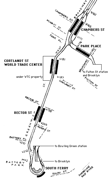
diagram |
|
The section marked as under WTC property was not the only damaged portion. New structure was being built approximately from Park Place to Rector St (the original Rector St station survived). New York City Transit released photos of Cortlandt St station to the news media the week of 24 September. All of this is now gone. |
|
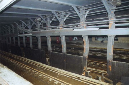
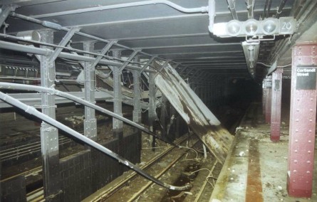
Above, subway columns are buckled from the impact, near the center of the station. Below, nearby, probably facing uptown, steel members from the buildings speared through the earth and the roof and even into the tunnel floor. |
|
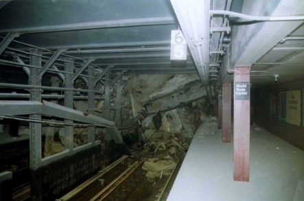
The following three all face to the downtown end of the station, where the tunnel has collapsed. The floor is covered with white dust. |
|
On the downtown platform, the stop marker for short 5 and 6 car trains put the rear car at the Vesey St end where the fulltime entrance was located. The other entrance directly to the World Trade Center was closed at off hours. Below is the uptown platform. The first one looks across to the downtown side (compare the poster) and the second view is just to the left (compare the diagonal steel beams). |
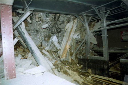
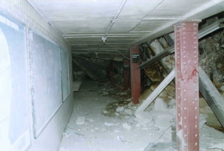
|
New York City Transit photos, supplied to this page courtesy of www.nycsubway.org. |
|
|
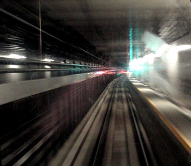
|
Larry Fendrick grabbed a shot out the front train window two days after the line reopened, showing the shell of the unfinished new station. Photo copyright by Laurance Fendrick, 2002. From subway.com.ru. |

|
|
|
|
|
|
|