|
|
by Joseph Brennan. Copyright 2001, 2002. |
These stations are closed temporarily while the World Trade Center area is being cleared and rebuilt. Let me repeat the statement on the main page that entering closed areas is illegal and dangerous. That goes double for this portion of the subway. Cortlandt St / World Trade CenterPassenger service: July 1918 - September 2001. Existing abandoned portions: Absolutely nothing remains. Touring: The public viewing platform may allow a view of the site where the station once existed. Rector StPassenger service: July 1918 - September 2001. Existing abandoned portions: two side platforms on two tracks not in service. Touring: The street entrances can be seen on Greenwich St. There is no way to view the station. It is expected to open again in late 2002. South FerryPassenger service: July 1905 - September 2001. Existing abandoned portions: Two side platforms (one closed since 1977) on two tracks in non-revenue service. Touring: The entrance in the plaza outside the Staten Island Ferry terminal can be seen. There is no way to view the station. It is expected to open again in late 2002. construction and operationThe branch line from Chambers St to South Ferry via Greenwich St was built as part of the Seventh Ave subway, one of the IRT routes of the Dual System announced in 1913. It opened in July 1918. The routing plan is that Seventh Ave locals run by this branch to South Ferry, while Seventh Ave expresses turn off and run to Brooklyn via Park Place and William St. Although it is mostly just a two track line, construction was not simple. The streets are narrow, and buildings already old in 1913 had to be supported along the edges of the excavation. The 9 Ave El ran overhead the length of Greenwich St. At Dey St, about the center of Cortlandt St station, the contractors came across the hull of a ship that burned and sank in colonial times; and under Battery Park they found cannonballs. Greenwich St marks approximately the original shoreline. Cortlandt St and Rector St stations were extended north and south respectively in 1966 to a full ten car length. Cortlandt St was extensively renovated in 1972-1976 and renamed Cortland St / World Trade Center. The original tile was completely covered or removed, but one of the original mosaic pictures of a ferry is now in the Transit Museum. Several railroad ferries to New Jersey terminals had once been located close by on West Street. A new street entrance was constructed at the north end, to provide access out to a public street at Vesey St. Modest stairway entrances with limited open hours were also available off the World Trade Center concourse. They were hard to find. South Ferry station was older, opened in 1905 as part of the first subway route to Brooklyn. See the Bowling Green and South Ferry page for more on its history. The portion of the subway between Park Place and Cedar Street was destroyed on 11 September 2001 in the collapse of the World Trade Center. This portion, originally under Greenwich St, ran through the middle of the World Trade Center property. Part of the two plaza buildings, but not the Twin Towers, stood directly over the line, and so did the indoor mall or concourse at ground level. Deeper underground levels were located below the grade of the subway with the subway crossing over them like a bridge. The wide escalator bank going down to the PATH World Trade Center station crossed under the subway station. It was the only place where a subway line ran effectively through a large building, but nothing was done to open it up and make this a point of interest. Here's a survey of the damage, starting from the north end. A three-foot thick concrete and steel plug has been built at about Park Place, protecting against possible flooding should the World Trade Center foundation not hold. The next block down to Barclay St was badly damaged. The next block to Vesey St totally collapsed under the fall of 48-story Building 7 which had stood along the west side of the subway, and this section of about 220 feet has been filled with concrete to provide a safe foundation for recovery vehicles at street level. Under the World Trade Center property itself, the northern part of the station was severely damaged. The columns were bent and the ceiling sloped downward to the south. For about 200 feet in the station and another 175 feet south, the tunnel was again totally collapsed, where it the top of Building 2, one of the 110-story towers, hit it "like a pile driver" as one of the MTA engineers put it. In the block south of the World Trade Center property, between Liberty and Cedar St, is another plug like the one at Park Place. In addition to the two totally collapsed sections, many columns were bent, and some steel beams from the buildings had run through the ground, into the tunnels and on into the floor. The MTA announced in January 2002 that the line would be open by the end of the year, in a very expedited project. Part of the tunnel was already daylighted by the middle of January, and by March the damaged portion of the subway had been completely removed. In April, new structure was going up. A photograph shot on 16 April showed the completed new concrete base and the first steel bents going up for the framework around the tracks. Completion was estimated in April as October 2002. Cortlandt St station is completely gone, the first subway station in New York to be not only closed but totally removed. The quick construction will provide about 2500 feet of new subway tunnel with no station, a simple two-track structure similar to the old. A new station will be built later when the site is redeveloped, designed to fit in with whatever plans are made. No damage has been reported at Rector St station. A substantial amount of material blew into the station through the stairway entrances and ventilation grates. It is of no value while the line is inoperable, so it will be closed until trains can run again. While the line is closed, a double crossover will be installed south of the station to allow operation with Rector St as a terminal during future rebuilding of South Ferry. South Ferry was not damaged at all. It will not be opened till trains run again from Chambers St. Trains from the Lexington Ave line can run to South Ferry station, as they had done up to 1977, but probably they will not. The shuttle platform at Bowling Green happened to be closed for asbestos abatement in September 2001, but even once it is available, there are fears that the necessarily short trains and single stairway at Bowling Green would not be adequate. Ferry riders will spread out to other stations in the area for the duration. |
diagram |
|
The section marked as under WTC property is not the only damaged portion. New structure is being built approximately from Park Place to Rector St. While the switches north of Chambers St provide for almost any movement, they do not make it practical to end local trains at the station while maintaining service through to Park Place and Brooklyn. Terminating trains would block the downtown express track in the station. For this reason, the temporary train service uses the Chambers St switches only to bring 1 2 local trains to the center tracks for Brooklyn service. 3 trains terminate in the downtown express track at 14 St, blocking express service from running further south, but keeping clear of Chambers St. New York City Transit released photos of Cortlandt St station to the news media the week of 24 September. |
|
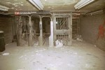
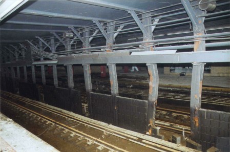
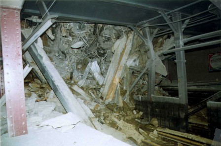
Above, subway columns are buckled from the impact, near the center of the station. Below, nearby, probably facing uptown, steel members from the buildings speared through the earth and the roof and even into the tunnel floor. |
|
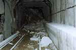
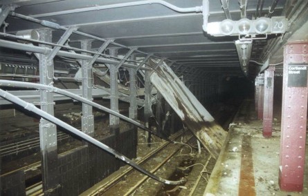
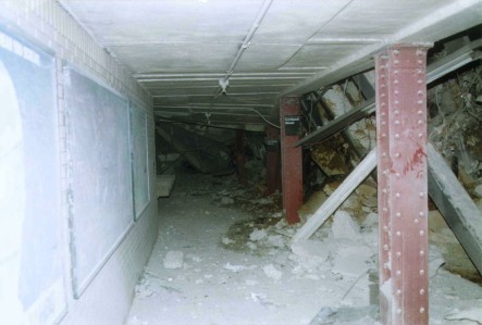
The following three all face to the downtown end of the station, where the tunnel has collapsed. The floor is covered with white dust. |
|
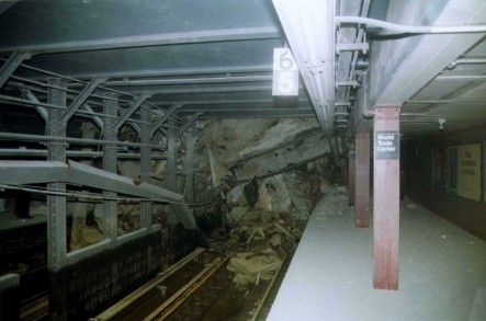
On the downtown platform, the stop marker for short 5 and 6 car trains put the rear car at the Vesey St end where the fulltime entrance was located. The other entrance directly to the World Trade Center was closed at off hours. Below is the uptown platform. The first one looks across to the downtown side (compare the poster) and the second view is just to the left (compare the diagonal steel beams). |
|
New York City Transit photos, supplied to this page courtesy of www.nycsubway.org. |
|
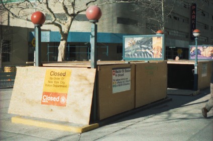
Seen in March 2002, the entrance to Rector St station near Morris St is boarded up and posted with a police notice. The MTA sign on the side suggests nearby open subway lines. |

|
|
|
|
|
|
|
![]()