|
|
by Joseph Brennan. Copyright 2001, 2002. |
Hudson TerminalPassenger service: July 1909 - July 1971. Existing abandoned portions: NONE. Touring: The site is along the west side of Church St, under the current street entrance to the PATH station. construction and operationHudson Terminal was the predecessor of the World Trade Center station on the PATH system. PATH is a subway connecting New York and New Jersey. Unlike the other subway lines in New York, it was not built by the city, but was constructed by the Hudson and Manhattan Railroad and its predecessor companies. The main purpose of the H & M was to connect railroad and streetcar terminals on the New Jersey waterfront with points in Manhattan. The H & M's only station downtown near Wall Street was designed to handle as many passengers as possible to meet the demands of rush hour traffic. Hudson Terminal was a marvel written up in engineering and architectural journals, with a carefully planned system of gentle ramps from street level to the mezzanine, to avoid the delays in pedestrian flow caused by stairs. Train movements were speeded by using a loop, but in contrast to the subway loops at City Hall and South Ferry, at Hudson Terminal the track at the platforms was kept straight, to minimize the dangerous gaps between the cars and platforms, except at the extreme ends of the platforms. The two single-track tubes under the Hudson River separated as they came east, entering Manhattan two blocks apart. The five-track loop was located under private property cleared for construction of the station. The property occupied the length of two city blocks along the west side of Church St from Cortlandt St to Fulton St, bisected by Dey St. Above the station, the H & M then built two office towers, the Hudson Terminal Buildings, which brought in rental income. The two buildings matched but were not identical, because the more southerly block was larger. The H & M was sold to the Port of New York Authority in 1962 following years of bankruptcy. The efficient Hudson Terminal station was doomed by the new owners' plans for the World Trade Center development, which included the Hudson Terminal site and many more neighboring blocks of old buildings. The Port Authority took the opportunity to resite and lengthen the station. As the tracks enter the property at West St, they now swing first away from each other to increase the separation between them, and then curve back torward each other into a much longer station. The new station is west of the old, and at a lower grade, so it was possible to build the new station and its approaches while normal service continued to Hudson Terminal. The new station, called World Trade Center, opened in July 1971 and the old station was closed at the same time. Some parts of the old station's track level were incorporated into the World Trade Center, and that is why it is listed here as an abandoned station still partly in existence. But all of the mezzanine level was completely destroyed by 1972. Some of the remains of Hudson Terminal survived the collapse of the World Trade Center towers on 11 September 2001. There was even talk in November 2001 of reusing it, if it would restore PATH service to lower Manhattan sooner than reopening World Trade Center station. The problem of the short platforms was not mentioned. The station became a delayed casualty of the 9 11 disaster in 2008 when it was destroyed during construction of a new building on the site. The eastbound tube had been visible for seven years as a circular opening high in the foundation wall of the World Trade Center, near the south end of the PATH station platform. This part was destroyed in October 2008. |
diagram
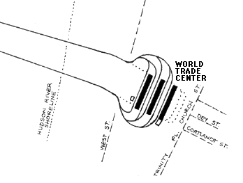
The diagram shows the location of the World Trade Center station (closed since 11 September 2001) and, by dotted lines, the former Hudson Terminal and its approaches. The inbound track under the Hudson reaches Manhattan at the foot of Cortlandt St and originally ran straight until reaching the station site near Church St. A right angle turn brought the track into the five tracks with platforms that ran parallel to Church St. A second right angle turn led to the track running straight under Fulton St back to the Hudson. The new construction by PATH starts just east of West St. At this point the original iron-ring tube now ends as the route crosses inside the large caisson basement of the World Trade Center complex. The tracks turn out to increase the distance between them and then turn into a much longer station. All of this east of West St is under the World Trade Center property, and is part of the extensive basement levels that run much deeper than PATH. The World Trade Center station includes two sections of non-public platform, namely a section of the outermost platform and a short innermost platform. The old tubes cross over the new station at about the platform ends, but this is not visible. |
|
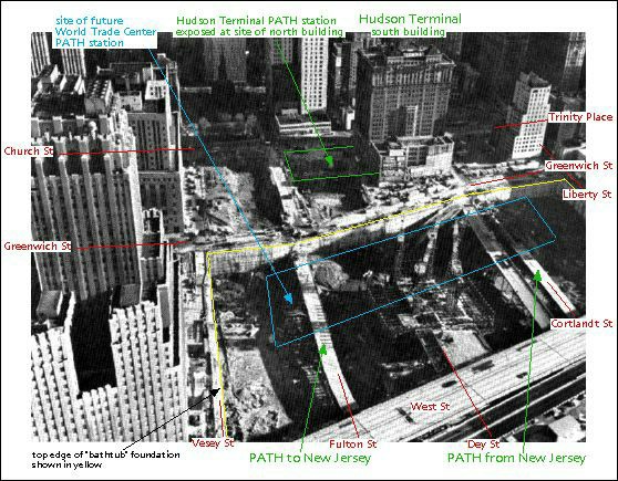
The relationship of the two terminals can be seen in this aerial view of the World Trade Center property under construction. During construction of the large "bathtub" foundation west of Greenwich St, the old tubes were visible in the excavation. They can actually be seen here, with a temporary flat roof protecting them. From the trains there was no sense of this "elevated" section since the tubes were kept intact. The IRT subway (1 9 trains) runs under Greenwich St, crossing over the old tubes to Hudson Terminal. The new route to the World Trade Center station is completely west of the subway. A larger version of this image, without the markings, is on the Building the World Trade Center page at www.nycsubway.org. |
|
|
|
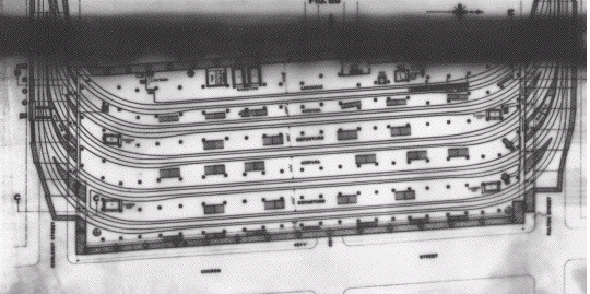
A plan of Hudson Terminal shows the five tracks and six platforms and how tightly they fit between Cortlandt St and Fulton St. Church St is at the bottom. Hudson and Manhattan Railroad, Terence Kennedy Collection. The original photographic plate is damaged. Scan copyright 2000 by Terence M Kennedy. See http://www.tmk.com/hm_gallery for details. |
|
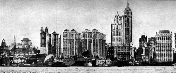
King's Views of New York for 1908-1909 included this retouched 1907 Underhill photo showing the Hudson Terminal buildings, calling the pair one of the "three marvels of 1908" along with the City Investing Building and Singer Building, the two taller towers to the right. All three marvels are convincingly painted onto the photo by the King's experts. In the foreground are the ferries of the Pennsylvania Railroad and Central Railroad of New Jersey. |
|
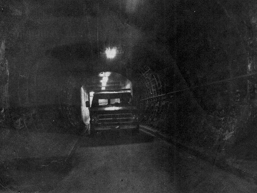
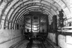
This remarkable photo ran in the October 1985 issue of PATHways, a handout newsletter for PATH riders. It shows a van driving into the former Hudson Terminal space through a section of original H & M tunnel with the usual cast iron rings. The accompanying text says that the platforms had been removed and that the space at the former track level was used as a loading dock. (The photo was not well reproduced on newsprint and the uneven black inking is on the printed original.) |
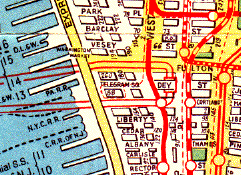 The Hagstrom map, shown here in the 1945 edition, always showed the H & M system with square station symbols to differentiate it from the subway. When the map was designed in 1934, the subway was three separate systems run by as many operators, two of them for-profit companies like the H & M, but the H & M was considered to be somewhat different. It had different fares by distance and was even classified by the federal government as a railroad. The station is shown by a box at Dey St, its midpoint. The station entrances were large openings into both of the Hudson Terminal buildings from Church St and all three side streets. |
|
The 1928 Red Book guide to Brooklyn thoughtfully listed the H & M trains the same way as it listed subway lines, something the Manhattan guides did not always do. The Hudson and Manhattan system was popularly known as the Hudson Tubes. |
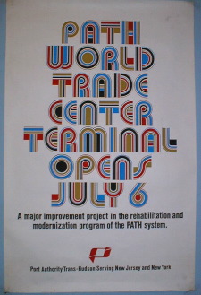
PATH announced the opening of World Trade Center, and implicitly the closing of Hudson Terminal, with a stylish poster. PATH, Terence Kennedy Collection. Scan copyright 2000 by Terence M Kennedy. See http://www.tmk.com/hm_gallery for details. |
|
|

|
|
|
![]()
