|
|
by Joseph Brennan. Copyright 2001, 2002. |
THIS PLATFORM IS OPEN
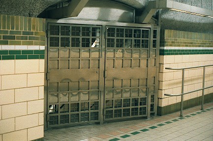
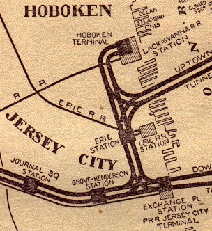
construction and operationThe station was originally called Erie, because it was located at the Jersey City terminal of the Erie Railroad. It was opened in August 1909 on the line from Hoboken to Hudson Terminal. In the original plan for the Hudson and Manhattan Railroad, there was to be a route, never built, directly from Erie to Hudson Terminal. The junction north of the station, called Caisson 3, was built with a provision for the additional two tracks. The unbuilt line would have had a new Erie station. The Erie Railroad itself had plans to rebuild their old wooden terminal, so the Hudson and Manhattan provided a single island platform at Erie, pending future developments. When the Erie Railroad decided instead to renovate the existing terminal, the Hudson and Manhattan also renovated their Erie station, adding a side platform, the one now abandoned, in 1924. The mezzanine area was expanded and led to separate stairways up to each platform of the Erie terminal. Erie was a busy suburban railroad terminal. In the two-hour peak from 16:00 to 18:00, there were 38 departures in 1910, and 59 in 1935. However there was little other business, in contrast to Hoboken and Exchange Place, which were trolley hubs and had nearby business and residential areas. Erie station was served by one local trolley line, and most of the nearby property was freight yards. In the post-war period, the Erie Railroad's fortunes waned, and it sought consolidation with its better-managed rival, the Delaware, Lackawanna and Western, which had a newer terminal of 1908 at Hoboken. Non rush hour Erie trains were re-routed to Hoboken in October 1956, as a start. As of March 1957, most rush hour trains also ran to Hoboken, leaving just the few rush hour trains of the tenant New York, Susquehanna and Western Railroad and of the Erie's Northern Branch, until the Erie terminal closed in December 1958. The two railroads merged in 1960 to form the Erie Lackawanna. The Hudson and Manhattan's Erie station was left almost without purpose. Most of the surrounding land was vacated as the Erie Lackawanna consolidated even its freight operations elsewhere. Erie station was closed on nights and weekends possibly as early as 1956, when the Erie withdrew all but rush hour trains. It might have been abandoned altogether, but it provided a transfer between two Hudson and Manhattan services for local passengers going between Hoboken and other New Jersey points. Also by about 1956, the side platform was closed as totally unnecessary. In its role as a transfer station, the island platform was ideal. The station name was changed to Pavonia Ave or Pavonia after the Erie moved out. Pavonia Ave was the only local street that ran to the station site. Most of the mezzanine space was near useless, and only one stairway at the north end of the platform was open. This dismal state of affairs continued into the PATH era until the development of the former railroad yards as Newport City, later called Newport Center. The station was renamed Pavonia / Newport in 1988, and most importantly, it was restored to fulltime service. It is now a busy station again, and not only in rush hours as it once was. In 2001, plans were announced to reopen the side platform to better accommodate the crowds now using the station. Unfortunately, in the renovation of 1986-1988, only limited access to the side platform was provided, so the stairs had to be enlarged. The side platform reopened on 10 August 2003, days and evenings. It will be closed during overnight hours. |
diagram |
|
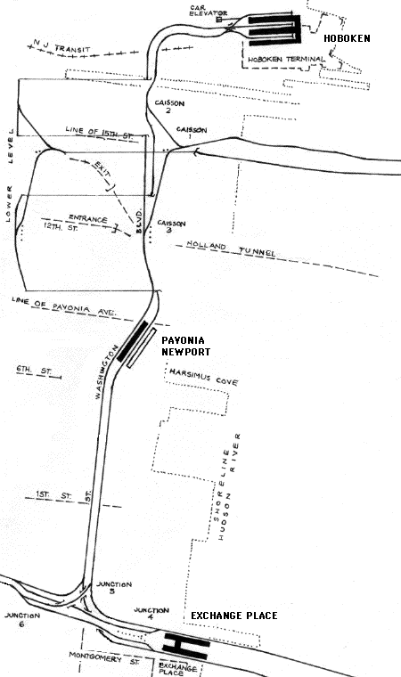
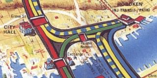
Pavonia sits between two triangular junctions. Those to the north are built in waterproof structures called caissons, while those to the south were built in rock tunnels. The caissons each have two levels. The train routings are from upper right 33 St Manhattan to lower left Journal Square Jersey City, and from Hoboken Terminal to lower right World Trade Center Manhattan. The shore lines shown are the old edge of land before the development of Newport Center and other recent projects. As a point of interest, the winding track coming in from 33 St (upper right) is the brick tunnel built in the late 1870's for an uncompleted Hudson tunnel project. The never-built direct line through Erie would have come off at Caisson 3, where dotted lines show the constructed wide place, and then run to a new station more directly under the Erie Railroad terminal, and then into a diagonal Hudson crossing. The terminal was on the north side of Pavonia Ave, as indicated by the way the mezzanine ramps still lead north to a modern entrance at the former street location. The mezzanine once continued across the street to the stairs to each platform. The location of the Hudson and Manhattan station was forced south to where it is by the location of the Caisson 3 in the junction, which was in turn forced by the company's use of the nineteenth century tunnel. |
 The Hudson and Manhattan Railroad's map in the Official Guide of the Railways (1934) shows the position of Erie station in the network. |
|
|
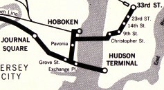 The PATH Service Guide map of 1967 showed the station as Pavonia. |
 The PATH Service Guide map of 1977 called it Pavonia Ave. |
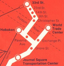
 The pictorial PATH map of 1987 was the last to call it Pavonia Ave. The blue and yellow line, showing the service on nights and weekends (changing ends en route at Hoboken), does not have a Pavonia stop. |
 The same map in 1988 has the new name, Pavonia Newport. The art had not yet been changed to show that the station was now open full time, but it was. |
|
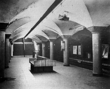
Paul A Carleton photographed Pavonia in its decay in 1979. The closed platform, on the right, is dark and has advertisements mounted near the platform edge. Photo copyright 1979 by Paul A Carleton. From Paul Carleton, The Hudson and Manhattan Railroad Revisited, Dunnellon FL: D Carleton Railbooks, 1990. |
|
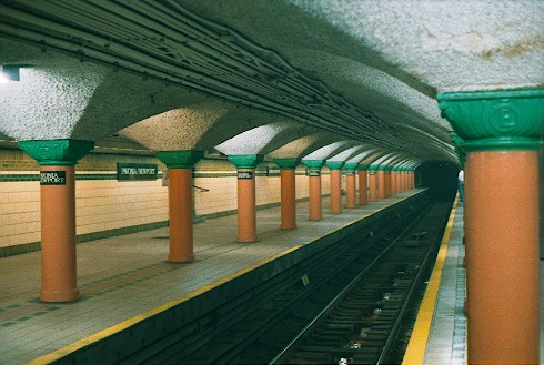
By contrast, today the station is well lit and painted in bright colors. The closed platform, left, looks as well cared for as the open one. A railing of one of the stairways from the closed platform is just visible. |
|
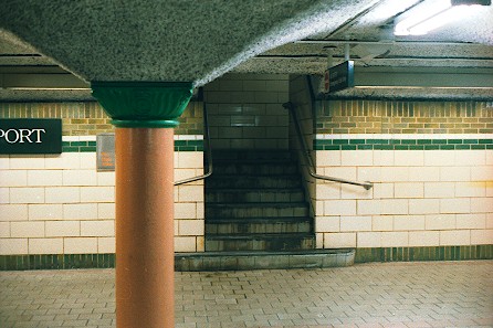
The two small stairways like this one go up to a landing and then to the mezzanine level. |
|
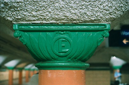
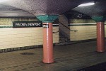
The thick columns of the station still have the E for Erie, no doubt puzzling many of today's riders. |
|
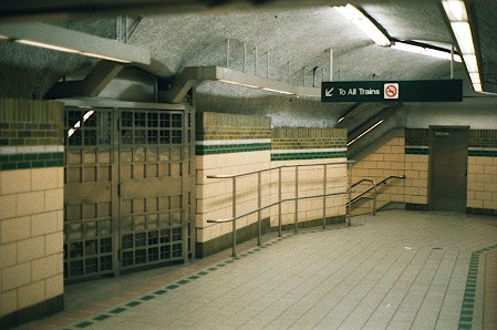
There are two passageways from the station at mezzanine level. One, closed after 1956 but now open, leads from a mezzanine over the center of the station. It is reached from the stairway near the center of the open platform and from the two narrow stairways on the closed platform. The other, as shown here, leads to the north end stairways of the closed platform, left, and the open platform. Along the right side once ran the Travolator, a conveyor belt to carry passengers up the ramp, similar to those now found in airports. It was left abandoned as late as the 1970's, but all traces are now gone. |
|
|
The 1928 Red Book guide to Brooklyn listed the station, as "Erie R.R. sta." on the routes from Hudson Terminal to Hoboken and from 33 St to Newark (it incorrectly shows Hoboken en route). |

|
|
|
![]()