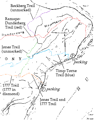
Hikers can see the Dunderberg Spiral Railway by using any of several marked and unmarked trails on the mountain. The best guidebook to the trails is Harriman Trails: a Guide and History by William J Myles, New York: New York--New Jersey Trail Conference, 1992, available at bookstores or from the Conference. The following information is from that book, from an older guide, Harriman Park Trail Guide by William Hoeferlin, and from my own explorations. The bold numbers are tenths of a mile, some from Myles and some interpolated from maps.
The less marked the trail, the more a good map is needed. Besides the maps here, also consider getting the Harriman--Bear Mountain Trails map set put out by the New York--New Jersey Trail Conference(maps 3 and 4, sold together).
The Timp-Torne Trail (T-T), marked by a simple blue blaze, is easy to follow and provides a quick route past the two DSR tunnels and along a representative section of grade. The portion of interest to us is only 1.1 miles long and has at worst a couple of steep climbs as it rises 600 feet in that distance.
|
See the Lower Incline locator map.
0.0 The trailhead is located on highway 9W just south of the fork where a side road goes to Jones Point. Use the dirt parking lot on the land side of fork, and walk south until you see the trailhead, marked by three blue blazes.
After a level section through bushy trees, there are stone "steps" up to the end of the DSR down grade. T-T follows the DSR fill briefly.
0.1 As the Lower Tunnel comes into view, T-T rises up the bank on the north side of the grade to reach the top of the tunnel. At this point, it is worthwhile to go just off trail for a walk through to the unfinished far side of the tunnel, as well as to look out from the top of it.
T-T follows the Lower Incline up to about 150 feet.
0.2 Just after passing a large rock on the right, T-T takes a sharp left turn, marked (like all turns) by a double blue blaze. Level grassy area on the right. At this important location, where the trail leaves the DSR, the incline grade is not clear, and just up from here is a washed-out section. But note the presence of large broken stones that formed the subgrade of the DSR earth fill, which you will see elsewhere.
0.4 Viewpoint at about 400 feet, at about where the next DSR grade would cross had it been built. T-T turns right (north), and some steep rocky hillside follows.
See the Tunnel locator map.
0.6 Meet the end of a DSR grade, about 560 feet. T-T follows this grade gently uphill. As you are about to climb the grade and turn left onto it, look right. If you imagine a fill crossing the ravine here going up the mountain, and look to its right, there seems to be more grade on the far side. This gap was either never built or has possibly been washed out by the small stream in the ravine.
T-T follows along an excellent example of DSR "hillside grade". It follows the contour of the hillside, but with cutting on the uphill side and fill on the downhill side, so as to form a level shelf for the trackway. After a time, the next DSR level begins coming into view up on the hillside to the right, as you approach the Upper Tunnel.
0.9 T-T turns off the DSR grade, and crosses the short distance over to the next highest DSR grade. Upon reaching that grade, look upgrade to the right a moment for a suggestion of how much tree clearing had been done on the T-T portion of the grade.
T-T runs gently downhill, as the cars would have done, and the tunnel comes into view. T-T runs up to the tunnel entrance before turning off to the left down a short DSR construction road bypassing the tunnel. Unfortunately water tends to pool in the tunnel, not deep but enough to discourage anyone without waterproof boots. If you bring a strong flashlight you can see the rough stone walls better.
1.0 T-T follows DSR around a curve built out from the hillside on a high fill. From here is a wonderful view down the Hudson, which DSR riders would have seen just after emerging from the tunnel. T-T continues on the grade through a rock cut and then turns left off the DSR. At this point, follow the grade a moment longer to see its end in a rock cut at the "back" of the tunnel. The solid rock here shows that the tunnel was never completed.
1.1 Cross a stream on stepping stones, and then cross the Jones Trail. You can hear waterfalls (from below this point). From here, T-T leaves the DSR area and continues almost 10 miles to reach 9W north of Bear Mountain. Jones was built by the DSR to bring workers and materials to construction sites. See its description below.
If you're not yet tired, follow the Jones Trail (see below) up to the next DSR grade and look around up there before heading back down. Another route back would be to follow the DSR grade gently uphill from the tunnel to the incline, and then go down the incline, but do this only with a map since it is well off marked trails and parts of the way are not clear.
The part of T-T described here was prepared only in 1987, to replace an earlier routing farther south that had been found the previous year to encroach private property. The new routing follows the advice of Gordon J Thompson, who wrote in 1977 that "consideration should be given" to marking the DSR as a trail and that the DSR "is superior in location and scenic vista to the currently blazed trails". Members of the Appalachian Mountain Club, New York Chapter, cleared the trail and removed debris from the tunnel.
The R-D Trail is the oldest marked trail in the park, dating from 1920. It does not follow any part of the DSR grade, although it crosses it several times, and it can therefore be useful in cutting between levels. The only part I walked was on the mountaintop, from the top of the incline west to the next grade down. This segment includes a good viewpoint north, from a bare rocky point.
The trailhead of R-D is located in the Jones Point hamlet, where there is some parking. Highway 9W has been reconstructed in the past few years with fencing and a rock cut along the uphill side, and it might be advisable to start instead from the same parking area mentioned above for the T-T and follow the edge of 9W up to the trail at 0.15, and thus avoid crossing the highway. Look for the R-D blazes of red dot on white. R-D runs steeply uphill, 800 feet up in about 3500, with some zigzag shown on the maps. It crosses two DSR grades at an unbuilt loop near 500 feet elevation and another grade at about 700 feet, at 0.8. There are viewpoints to the river.
See the Parapet locator map.
Gradually turning left, R-D deliberately goes over the highest points of the mountain, over 900 feet. It eventually crosses a point that must be just about the top of the Upper Incline 1.4, which can be found by looking for the short section of fill just north of this intended crossing. From there, it continues climbing up and down, straight across the "Parapet Trail" DSR grade 1.7, and continues on away from the DSR for another 18 miles to Tuxedo railroad station.
The 1777 Trail was established in 1975 to mark the route of the British army from Stony Point to Fort Montgomery, when the main road did not run around Jones Point but crossed over the hills. The portion of interest to us here is actually not the route of the army, but rather a bypass from highway 9W to meet that route where it enters the park from private property. This portion is joint with the otherwise unmarked Jones Trail, and the blazes help locate the trailhead at 9W. It was also the route of the Timp-Torne Trail from 1952 to 1987, and some faded blue T-T blazes can still be seen.
|
The trailhead is about 200 feet north of a parking lot on the river side of highway 9W. Walk across the highway at the lot, where there is a little more visibility than at the trailhead, although this crossing will be the most dangerous part of the hike regardless.
0.0 1777 trailhead is marked by three blazes, white diamond-shaped markers with a red 1777. The trail goes up the bank from the highway and then less steeply uphill.
0.1 Cross DSR grade. A short walk left (south) leads to a deep cut and the end of the grade. A slightly longer walk north leads around a gentle curve, across a less distinct woods road, to another deep cut, and onto a fill ending high above a brook in a pretty ravine.
0.2 1777 becomes a definite graded road, called the Jones Trail, built by the DSR. The grade is not clear all the way to 9W, and I am not sure that it even ran the way the 1777 Trail runs, but may instead have followed the course of the less distinct road that heads for 9W just north of the 1777 Trail. This less distinct road also can be seen running uphill, where it meets the next DSR grade.
0.4 As 1777-Jones goes up the hillside, note the dry stonework for culverts where it crosses streams. At one, some remains of the wood deck can be seen in the stone. The last stream is a little wider, and hikers can use a simple wooden bridge built in 1987 across the old stone abutments.
From the bridge, the trail turns left and begins a steeper climb up the ravine down which the stream tumbles. The trail finally turns to the right through a deep cutting in the earth bank, at about the location where the next DSR grade would have crossed if built.
0.6 Just as the trail straightens out, the 1777 Trail takes a sharp left off the Jones Trail. A pile of brush has been laid across Jones here, to stop unwary hikers from following the obvious route straight ahead, but it can be stepped around.
From here, the 1777 Trail leaves the DSR area. Continue on the Jones Trail, below.
The Jones Trail was built in 1890 by the DSR to reach construction sites up on the mountain. You can see on the map that many of the long completed sections run off Jones, which is graded to the same width as the railway and has sections of fill built of the same subgrade of large stones as on the DSR proper. However, Jones did not have to follow a strict profile, so its steepness varies and it even has a short downhill grade on its way up the mountain.
|
0.6 Part ways with the 1777 Trail. From here up, Jones is not marked by blazes, but the wide pathway and obvious grade makes it easy to follow up the hillside. There are only a few trees down in the path. As it climbs, there are increasingly good views to the woods below and eventually even to the Hudson.
See the Tunnel locator map.
1.1 Cross Timp-Torne Trail, just after you begin to hear small waterfalls and see the stream comes into view on the right. Across the stream is the DSR grade near the Upper Tunnel.
Jones continues along the stream a short way longer, and then turns right to cross it on stepping stones in a swampy area, the only place where Jones is hard to follow. After crossing the stream, look to the ravine the stream comes from, and the next apparent path to the right of it is the Jones, which again becomes obvious once you begin to rise. The DSR company planned to build a small dam around here and flood this basin, to make a reservoir of fresh water for the summit and to use the hydro power for electricity.
1.2 Jones again climbs uphill. The character of the vegetation changes around this point to lower trees and more brush. The lower part of the mountain has tall trees but it is fairly open at ground level and you can see for some distance. Jones here enters an area of laurels and other bushes, which are also found on other high trails. The last part of Jones becomes more level.
See the Parapet locator map.
1.5 Jones ends at a T junction with the next DSR grade ("Parapet Trail" section). It is sometimes considered to continue to the left along the DSR to meet the Ramapo-Dunderberg trail in about 750 feet.
To return, consider turning right along the Parapet's Hudson River side. At the end of the grade, go up the rock and find the incline, and then make your way up to meet the R-D Trail, and loop back via the R-D and another part of the Parapet. This is not too hard to follow, but have a map. Another reasonable loop would be to go by either route to the incline, and then down the incline until you reach an unfinished cut in a rock outcrop, where you should go over the rock to the right (southwest) to find the end of the grade leading back to the tunnel. Be sure to take a map for this. While doing so, you might even sidetrack down to see the incline loop and come back up.
There is a second unmarked trail that starts on the DSR grade less than 500 feet east of the Upper Tunnel, and ends some 1000 feet later at the Parapet Trail DSR grade. Both ends are easy to find. If this is a DSR construction road, it's hard to say why it's so close to Jones, unless it was to replace Jones after that reservoir was built.
I did not walk the Bockberg Trail, nor is it essential to a survey of the DSR. It comes up the north side of Dunderberg from highway 9W, not near any recommended parking places on the highway. As a somewhat loosely defined unmarked trail, it is actually two trails from 9W to the DSR grade, with a crosstrail, making a sloppy "H" shape. The more easterly trail is shorter but steeper, and meets the DSR at the end of a constructed grade at about 760 feet. The westerly trail comes up at the place where the DSR crosses the Ramapo-Dunderberg Trail. Bockberg continues along the R-D for a very short way and then diverges left, leaving the DSR area.
The main reason to mention Bockberg is that it was the route of William T Howell when he "discovered" the DSR in 1906, following which he began spreading word to other hikers about it. He seems to have started up the easterly trail, and followed the crosstrail and westerly trail to reach the DSR where it now crosses the R-D (which did not yet exist). The "spring that never fails" is the source of the stream that runs between the two Bockberg trails up the mountain.
The book Harriman Trails suggests a hiking route up the inclines, west on R-D, and down Jones and T-T. "The prepared grade can be followed almost to the top of the mountain. When the obvious grade ends, hikers can climb over the top." While this is true, walking the incline is easier said than done.
|
See the Lower Incline and Upper Incline locator maps.
The Lower Incline has eroded or incomplete sections, and you may wander a bit from losing the way and going around obstacles. The only good sections are the Timp-Torne Trail and a midsection that ends at the stone wall. Going up, just try to continue straight from the T-T. Going down, the biggest problem is locating the top: the intended right-angle crossing is just off the bottom of the Upper Incline, and you will need to wander across a small level area and look for the top of a rock cut.
The loop between the inclines is interesting because of its incomplete state. One rock cut is just begun on both sides, and another is not done at all. A small stream has washed out a remarkable gap in the high fill on the southeast side. The fill where the Lower would cross the Upper is not there at all.
The Upper Incline is much better preserved, partly because much more of it is in rock cut. There is one short unbuilt section at a rock outcrop and one washout in a fill, and the very top was not built, but it is still easier to follow. The higher of the two crossings with the downgrade was just being built when work stopped. Myers is correct, that from the end it is simple enough to continue in the same direction and reach the R-D Trail. Be sure to notice the fill on the far side of R-D, the highest existing point on the DSR. Probably the summit would have been right about at the R-D.
See the Parapet locator map.
This name is mentioned in Hoeferlin's book but is not in common use. This U-shaped 0.8 mile of the second spiral down from the top is very well preserved, and anyone getting this far up on the Jones Trail or incline should take the time to walk it. There are some fine views. For a path between the upper incline and the Jones Trail, while the R-D does have one excellent view north, the Parapet is at least as good, and is much easier to walk, despite a very short gap between the end and the incline.
See the Tunnel locator map.
The next long segment of downgrade runs 0.6 miles from close to the incline down to the portal of the Upper Tunnel. There are numerous trees down and a few boulders, but it is still an easy walk. As a hillside grade under tall trees, it is quite different in character from the Parapet. There are views only of the woods below.
The next segment is separated from this only by the tunnel, and but for that there would be 1.1 miles of continuous downgrade completed. This segment is maintained as part of T-T and is described above.
See the North Loop locator map.
I just never got north and east of the inclines. There are two loops here. One is the spiral, the U opposite the Parapet section, which seems just a few gaps short of adding another 0.7 of a mile to the 0.6-mile continous downgrade toward the tunnel. The other is the second switchback down, a narrow U continuing from the switchback around the tunnel, which also seems just short gaps from completion. I notice that Howell (1910) says he walked the latter from the Tunnel to near the point, went uphill, and walked back the former, without mentioning gaps, so it would be interesting to see why.
See the South Loop and South End locator maps.
I saw only a short stretch of the long southern portion of the DSR, that just off the 1777-Jones Trails. From Thompson's map, it looks like 2 miles of line were built, although he shows many short gaps either not built or destroyed. Some of it is outside the park and I don't know whether it can be walked at all. There seem to be several places where there would be views of ravines with streams, and possibly views to the Hudson although this whole section is no higher than 300 feet.