The Pittsburgh and Castle Shannon Railroad is the ancestor of the portion of the Blue Line between South Hills Junction and Castle Shannon.
A company eventually called the Pittsburgh Coal Company mined Coal Hill, now called Mount Washington, as early as 1825. This is the steep ridge immediately south of the Monongahela River opposite Pittsburgh. The mine was quite a ways up the slope, so an inclined plane was used to bring the black diamonds down to the river. The power was gravity. The loaded cars provided more than enough counterweight to lift the empties back up. My guess is they used a barney attached to each end of one rope. The cars would be placed on the uphill side of the barney in both directions so that it controls the descent and pushes on the ascent.
When the coal seams on Coal Hill played out, the Pittsburgh Coal Company developed more locations to the south in the Saw Mill Run valley. In 1861 the company created the Coal Hill Railroad to bring coal from there to the existing inclined plane. One of the coal mine tunnels was opened out the back forming a tunnel of 1700 feet, and the railroad was laid down the hill, around a "horseshoe curve", and into the valley for about a mile and a half to the new mine at Oak. It was still a private railroad handling only the company's coal trains. It was built to an odd forty-inch gauge, but since the cars never left the company's rails the gauge did not matter. The coal tunnel was made just large enough for the coal wagons. Notably, it was only five and a half feet in height.
Investors led by Milton Hays formed the Pittsburgh and Castle Shannon Railroad Company in 1871 and had the company buy out the Coal Hill Railroad, with all of its property and mineral rights, and with the lease of the Mount Washington property owned by the Bailey family that included the incline and the coal tunnel. The P&CS was a common carrier, meaning it had the right to offer passenger and freight services to the public, and its charter provided for building south as far as Finleyville in Washington County, seventeen miles. The company would be able to establish more coal mines farther south, but as a common carrier there were other opportunities too.
Part of the goal of the P&CS was to establish residential development at Fairhaven and Castle Shannon. The company bought up property and began to sell lots to prospective home owners who would use the P&CS to get to Pittsburgh. Fairhaven lots were sold in 1872 and Castle Shannon the next year. Travel time was promised to be 45 minutes. The single track started at Arlington stop in Castle Shannon (now a half mile up the Red Line from the junction) and followed the pre-1993 path of what is now the Blue Line to Warrington Avenue, and continued around the little horseshoe curve and through the coal tunnel. Evidence is that they changed cars in grounds at the top of the incline— namely a map of 1882 showing "depot for incline" at that point. The height of the coal tunnel was not enlarged until 1874, so the first passenger cars must have been something like those on amusement park trains. Running non-coal trains involved bringing loaded cars up the incline for the first time, so presumably it was converted to use a stationary steam engine in 1872 if not earlier.
The directors of the P&CS never authorized construction further south, to the annoyance of President Hays, who finally organized another company to do so. The only change to the P&CS up to its demise in 1912 was to replace the arrangement at Mount Washington. It took some years to happen but at length the civic authorities judged the coal tunnel to be unsafe for passengers, and in response the company constructed two new inclines in 1891 to take passengers up and over the top of the hill instead. Coal trains continued to use the old tunnel and incline. I wrote more about the confusing inclines and tunnels over here.
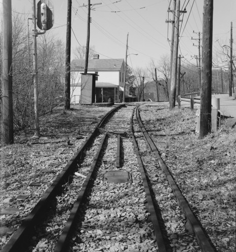
Denise stop looking north, 1996, after the end of service. Despite the modern intrusions this gives a good idea of the scene a hundred years ago. Note the right-hand rail that has fallen over. Is it possible that these are narrow-gauge rails still in place? This scene is totally gone now with the relocation of Denise stop and the removal of the house and crossroad. (from the Historic American Buildings Survey).
In 1900 the Pittsburgh Coal Company bought the financially ailing P&CS, effectively getting back what they sold in 1871 together with a passenger railway. Pittsburgh Coal operated it for five years mainly to keep coal traffic going. Pittsburgh Railways took over operations in 1905, leasing the property in order to get an off-street route for their two interurban trolley lines to points south. Besides the single-track main line itself the lease got them the two inclines, three locomotives, eight passenger or combination cars, and a whopping 285 freight cars, almost all of them coal wagons. It was clear what the main purpose of the P&CS had been! Pittsburgh Coal kept the coal tunnel and coal incline, but it was not for long. They ended coal train operations on the old P&CS in 1912.
Pittsburgh Railways added a rail on each side of the P&CS rails for their broad gauge trolleys, which began operating over the P&CS in 1909 from downtown Pittsburgh via the Smithfield Street bridge and the Mount Washington tunnel. A few narrow gauge steam passenger trains ran until 1912. After that year the narrow gauge rails were lifted except near curves and bridges where they were left as guard rails. The P&CS company remained in existence until 1950 as owner of the property.
With the steam trains gone and ample streetcar service to the city, Incline No. 2 became needless, and it was closed in 1914. By contrast Incline No. 1, as the Castle Shannon Incline, had a long life ending in 1964, so far outlasting the railroad that people must have wondered why it had the name of a town seven miles away. The lower station was just east of modern light rail stop Station Square, where the tracks curve toward the bridge, so if it had survived it would make a good connection with the modern light rail.
Pittsburgh Railways kept the main line of the P&CS in service with only a few changes. As always it was mainly single track, some of it on a steep hillisde, with passing sidings. It was known as the Overbrook Line, and handled a modest number of local city cars and more importantly interurban cars to the Washington and Charleroi lines. Because of the single track it could not sustain the level of frequent service most trolley lines had, but the relatively light population in the Saw Mill Run valley did not require as much.
In the 1920s three of the four major bridges were replaced in connection with widening of the streets that passed under. The Warrington Avenue Bridge was replaced in 1928 by a double-track open-deck through girder steel bridge between concrete abutments. The McKinley Park Bridge was replaced in 1929 by a single-track trestle of seventeen spans, three of them through girder steel spans and the rest built of steel stringers under the rails. The deck and supports were a mixture of steel and wood and stone masonry. The Oak Viaduct was replaced in 1928 by a longer crossing necessitated by the widening of Saw Mill Run Boulevard. Like the McKinley Park Bridge it was a single-track trestle made up of different parts, and here because of the wide span the center section was a pony truss bridge of 134 feet. The fourth bridge was not replaced. The original single-track wooden Reflectorville Viaduct did not pass over a public street, and that seems to account for its remaining in use until 1993. The only steel parts were stringers that Pittsburgh Railways installed under the rails in 1909.
In 1993 the Port Authority (operator since 1964) shut down the entire route. The many concerns included track and power, the safety of the old hillside grade, subsidence from abandoned mines, and increasing failure of brakes and other parts on the PCC cars that had seen decades of service. All cars from south of Castle Shannon were re-routed over the slower Beechview route for the next eleven years. By that time the Beechview (now Red Line) and South Hills Village lines had been rebuilt to modern light rail standards. After political and financial obstacles were overcome, reconstruction started in 1999 and was completed in 2004. The entire right of way was rebuilt for double track and some of it was relocated. All of the bridges and stations are new. Some notable changes (north to south) were:
A section of right of way out of South Hills Junction was abandoned including the location of the Warrington Avenue bridge.
Mckinley Park Bridge is new.
Right of way was relocated around Bon Air stop.
Reflectorville Viaduct is new.
Right of way was relocated around Denise stop.
Oak Viaduct is new.
New right of way bypasses the old stops Central, Inglewood, Overbrook, and Glenbury—and so the Overbrook Line no longer stops at Overbrook! This section was paved around the rails in 1977 to become part of the South Busway, and the stops had both bus and rail service, of which the bus was more frequent. When the rail line closed in 1993 the bus lines became the only service to those stops, and rail service never came back. The South Busway is still on the P&CS right of way.
Rearrangement of stops at Overbrook Junction. The Blue Line stop is called Willow, for the short street running on each side of the tracks. The Red Line stop across the street is still called Overbrook Junction but the Red Line's publicized terminal is the large stop with parking called Castle Shannon, which is actually a little outside the downtown of Castle Shannon proper.
I want to applaud Kevin Mueller for creating a front-window film of a ride on the Overbrook Line in 1989, before reconstruction, and for posting it to Youtube. See the Overbrook Line Film page for commentary.