Environmental Impacts
Water Levels
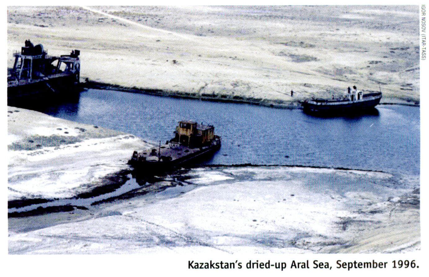
The primary effect of the Aral Sea desiccation has been the
significant loss of water in the sea. The water level has dropped
approximately 23 meters since the onset of its primary sources of
water being diverted (Zavialov 2005). Although the water level has
fluctuated up to a few meters in the past due to natural variability
in the water flow from the rivers, by 1970, the water loss exceeded
the limit of natural water level variation that has occurred in the
past.
The water budget is determined by several components: Inflow from the river, evaporation,
precipitation rates, and groundwater inflow. Net evaporation is defined as the difference
between evaporation and precipitation at the surface (Micklin 2007). The river inflow has
been rapidly decreasing since 1960. Net evaporation has also decreased, but at a slower rate
while the groundwater inflow has remained approximately the same. As a result, there was a
net deficit of water to the sea. The figure below shows the components of water balance that
resulted in the net deficit of incoming water flow (Micklin 2007).
In the first desiccation period, water level dropped by about 21 cm/year. In the next decade,
water level decreased by 57 cm/year, and afterwards the drop in water level started accelerating faster.
The acceleration of the rate of water loss from the Aral Sea can be explained by the positive feedback
between evaporation and Sea Surface Temperature. As the lake loses water, it becomes shallower.
The incoming solar radiation for a given square area now has to heat up a smaller volume of water, thus
the water temperature at the surface increases faster. This in turn lowers the specific humidity at the
surface, which further increases the rate of evaporation, thus eating a positive feedback loop.
Another factor that accelerated the evaporation is that the salinization of the lake has lead to vertical
stratification. Stratification is characterized by a rapid change in water temperature and salinity level
at a given horizontal or vertical region. Under this condition, the surface of the lake has a much lower
salt concentration than the bottom of the lake, and thus heats up faster than if the salt concentration was
distributed evenly.
After 1990 the rate of water loss has been slowly decreasing. There are negative feedback systems that
could have slowed down the loss of water in the region. First, is that as the sea surface area decreases,
so does evaporation, which slows down the desiccation process. Another negative feedback is due to increased
salinity - as salinity increases, the evaporation also decreases, which partially offsets the positive feedback
of water loss. Overall, the presence of both positive and negative feedback systems influences the rate of
water loss in the area.
Correlation of Salinity with Water Level
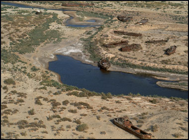
The desiccation of the Aral Sea was also characterized by a sharp
increase in the salinity of sea water. The salinity of water is
determined by the mass of salts dissolved in the water and the volume
of water. As the sea level dropped because of water loss, the inflow
of salts to the sea exceeded the salt discharge, and as a result,
salinity levels of the sea rose. In the first decade, the salinity
increased by 14%, which exceeded the threshold for many commercial
fish (Glantz 1999). As a result commercial fishing catches fell from
43,430 tons in 1960 to zero in 1980 (Bosch, 44). From 1960 to 2004,
surface salinity increased from 10ppt in 1960 to 92ppt in 2004
(Zavialov 2005). The steep rise in salinity is one of the curses that
hit the Aral Sea region when the Sea started shrinking, and is, with
the visible water loss, the element which alters landscape the most.
As the sea separated into different parts, the difference in salinity
between the eastern basin and the western basin also started growing,
with higher salinization in the eastern (smaller) basin (Zavialov
2005). Scientists were able to observe two types of correlations
between water and salt which increase the salinity of water as a result.
Negative Correlation: This obvious correlation explains how the
diminishing level of water creates more salinity, as a given amount of
salt gets diluted into a smaller volume. The diminishing level of the
Aral Sea has therefore caused the steep rise in salinity
(V.M.Lelevkin). Considering this fact, and based on changes over the
last 40 years, we can predict that melting glaciers, growth
population, and an increasing trend of water usage will lead to less
water flowing into the Aral and thus to an increase in salinity.
Positive Correlation: It happens when both underground water and
salinity rise at the same time. When agriculture uses furrow
irrigation, soil receives an excessive amount of water from rivers and
canals. Water then gets filtered by depositing the salt in the soil.
Excess water accumulated in groundwater that remains after filtration
raises the water table (top layer of underground water). Risen
groundwater dilutes and moves upward the salt resting in the soil.
Water moves upward and salt concentration increases in the surface
layers of the soil. The water then evaporates during day time, leaving
the salt behind as it becomes like a layer of snow on the surface of
the ground. Similar effects have been observed in Australia as well
(Australian Academy of Science).
SST Changes
The desiccation of the Aral Sea has been accompanied by the change in the Sea Surface Temperature. We see that
the summer SSTs have been increasing, while winter SSTs have been decreasing (Zavialov 2005). This is expected
because as the sea looses volume, it's heat capacity is reduced, therefore it can warm up and cool off faster than
before. The day to night variations in SSTs, which are responsible for the sea breezes, have also increased.
In a sense, Aral sea has started to exhibit a monsoon climate, which is characterized by seasonal climate change
due to warming & cooling of the sea. The desiccation period was also characterized by less ice covering of
the sea (Zavialov 2005). This can be explained by the fact that increased salt concentration lowers the freezing
point of water; therefore the temperature would now need to be lower for the water to turn into ice.
Desertification
The Aral Sea region experienced significant desertification during the desiccation period. The desertification
is characterized by degradation of the land and natural resources to the point that they can no longer be used.
Several factors influence the desertification, including the decline in the groundwater level. By cutting off
water supply to a region, the hydrological balance of the area becomes offset as more water leaves the region
than is coming into the region. Frequent low-water periods contributed to the shortfall of needed resources for
vegetation. The decline in the groundwater level in the Amudarya and Syrdarya deltas contributed to the piling
up of salt at the surface.This increase in salt content was later accompanied by a change in vegetative cover
because the plants began to die away as a result of the increased salinity of the sea. As a result, vegetation
in the region was reduced by at least 40%. A side effect of the decrease in the protective vegetation cover was
intensified winds, which led to more dust storms in the area. Six million hectares of agricultural land were
destroyed as a result of salinization and desertification (Bosch 2007).
Salinization of Soil
A sharp increase in salinization of lands is one of the most negative consequences of Aral Sea crisis.
Groundwater level decline also caused salt accumulation in the subsoils. This led to increase in salt
deposition in the soil profiles and reeds were replaced by grass saltworts as a result, which prevented
anything from growing there. Salinization of soils accelerated the desertification process as it accompanied
the sharp decline in groundwater level and the drying of subsoils. This eventually lead to soil erosion, one
of the primary reasons for extensive fertilizer use. In turn, these abusive fertilizing practices further
deteriorated soils and created pollution that went both into the Aral Sea through groundwater circulation and
into the air through dust storms.
Dust Storms
The desiccation of the Aral Sea greatly increased the number of dust and salt storms in the area. Satellite
images have revealed that there are up to ten major dust storms occurring annually in the region, most of them
occurring between the months of April and July (Glantz 1999). While before, the pressure from the water surface
dampened the strength of the northerly and north-easterly winds, the loss of the sea meant that it's protective
action from the wind was significantly reduced. The receding sea left behind large amount of salt, and
groundwater evaporation further increased the amount of salt from the exposed sea bed. The strong north-easterly
winds now pick up the sand, salt, and dust, creating strong dust storms. The salt content in the dust made
up about 3040% of the volume in the summer, and was as high as 90% in the winter (Hydrometeorological Center of
Uzbekistan). The storms are often between 150 and 300 km wide. The dust was distributed in areas far beyond the region - the dust from the Aral Sea region was
found as far as 500km away from the original source (Micklin 2007). Some of the salt reached the intensively
irrigated and cultivated soils, which even ruined the soil far away from the Aral Sea region. It was estimated
that the average amount of salt removed from the entire dried seabed was about 43 million metric tons between
1960 and 1984 (Glantz 1999).
(source:eol.jsc.nasa.gov)

Climate Change
The Aral sea desiccation period was accompanied by climate change. Before the desiccation period, the Aral Sea
regulated the climate in the region by softening strong Siberian winds in the winter, and cooling off the area
in the summer. The exact temperature increase resulting from the Aral Crisis is difficult to measure because
the entire Central Asia region has seen an increase in air temperature, so the effects due to the Aral Sea were
not isolated. Nevertheless, two studies based on observations made around the original perimeter of the Sea of
the variations in air flows and temperatures have permitted to differentiate how much of the changes we see can
be attributed to the larger scale trends and how much to the desiccation of the Sea per se. The two studies in
question (Small and Molosnova) were realized with different methods, and arrive to similar conclusions: that
the shrinking of the sea directly accounts for 50% to 66% this proportion varies with pressure and seasons and
remains high of the warming trend.(Khan, Vilfand and Zavialov) In the period from 1960 to 2000, the average
monthly air temperature has increased by 2°C to 6°C in the summer above and around the Sea(Zavialov 2005).
Correspondingly, the air temperature has also decreased during the winter. The magnitude of the change was
greatest southwest of the Aral Sea, where the north-easterly winds blow, as those winds got stronger. The result
was shorter and hotter summers, longer and colder winters, and a decrease in precipitations. Concerning future
temperature changes, estimates predict an increase ranging from 1.75 to 2.25°C on average in the region by 2050,
rising more in the summer (2 to 2.75°C) than in the winter (1.5 to 2°C). In terms of yearly precipitations, they
should increase by 5 to 20% in average by 2050, though again differentiated between summer and winter time. In
summer they would increase by 5 to 10% in the north and decrease by up to 5% in the south, while during winter
they would increase in both north and south of the Aral by respectively 5 to 10% and 20 to 25%.
( Ragab- Prudhomme 2002) The consequences of these changes pose a threat to populations who live in the area
and human activities, as we are going to see.
As population grows, the number of cars and all sorts of factories will increase. The local carbon dioxide
concentration will increase, which will increase air temperature further. Some people may argue that warmer
temperatures are good for planting and agriculture. They may argue that farmers can produce cotton or vegetation
all year round, but where to find enough water for the necessary irrigation? There are not enough water resources
even at the present time.
Dry air that accompanies high temperature, higher carbon dioxide concentration and water deficiency will
all lead to crop losses of agricultural plants. High temperature will additionally reduce the amount of grass
on the plain territories which in turn will lead to a decrease in natural fauna and cattle breeding (Lelevkin).
Air temperature will further increase due to geographical location of regions and the global warming effect.
Warming temperatures will further evaporate water and farmers will have to use more water to grow anything
compared to previous decades. This will speed up even more water usage, without counting the population growth
factor. The water value in the region will therefore continue to increase, and hopefully a change in practices
will eventually occur.
Melting Glaciers
It would seem unlikely that an inland sea in Uzbekistan could affect something so vast as earths climate.
Yet the truth is that the shrinking sea and salty dust storms have already changed the climate in the region
to the point of an unlikely return to the stability once present in the area. With the shrinking sea there is
not enough surface area to disrupt frigid north winds. Nor does the sea contribute the moisture it once did to
the snowfall in mountains of neighboring and more distant regions. In addition to the temperature steadily
increasing the dust and salt storms are coating the mountain glaciers nearby and causing a decrease in the
overall volume of ice. The degree of melting is over twelve times the rate of the pre-cotton growing era and
as there is less moisture in the air to replace the dissipating snow the glaciers continues to diminish. As
the glaciers continue to melt the weather will become less likely to experience the sort of seasonal stability
it once did.
We have just looked at the intricate behaviors of climate systems in the Aral region, including their interactions
and the chain reactions that we call positive feedbacks. Not only did they reshape the landscape and natural
balance of the region, they also affected dramatically the populations that live or used to live in this area.
Public health, access to drinkable water, migrations due to changing landscape and consequences of vanishing
wildlife are all matters that turn out to rely on stable climatic and hydrologic conditions. Appalling observations
that followed the climatic changes of the past decades have increased the toll of the irresponsible decisions that
were taken by the Soviet Union in the 1960s and of the inactions that followed. Endemic levels of anemia,
respiratory diseases and other kidney troubles were reached around the 1980s among the neighbor populations of
the Aral region, without anything preventing such diseases from spreading since changes in local climate were at
their origin. We will now explore the range of consequences on the human plan that these changes truly had.
Next