Introduction
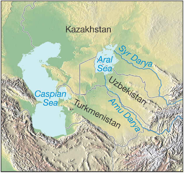
The Aral Sea is situated in Central Asia, between the Southern part of
Kazakhstan and Northern Uzbekistan. Up until the third quarter of the
20th century it was the world?s fourth largest saline lake, and
contained 10grams of salt per liter. The two rivers that feed it are
the Amu Darya and Syr Darya rivers, respectively reaching the Sea
through the South and the North. The Soviet government decided in the
1960s to divert those rivers so that they could irrigate the desert
region surrounding the Sea in order to favor agriculture rather than
supply the Aral Sea basin. The reason why we decided to explore the
implications up to today of this human alteration of the environment
is precisely that certain characteristics of the region, from its
geography to its population growth, account for dramatic consequences
since the canals have been dug. Those consequences range from
unexpected climate feedbacks to public health issues, affecting the
lives of millions of people in and out of the region.
By establishing a program to promote agriculture and especially that of cotton, Soviet
government led by Khrouchtchev in the 1950s deliberately deprived the Aral Sea of its two
main sources of water income, which almost immediately led to less water arriving to the sea.
Not only was all this water being diverted into canals at the expense of the Aral Sea supply,
but the majority of it was being soaked up by the desert and blatantly wasted (between 25% and
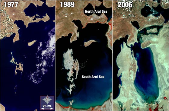
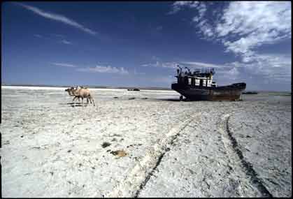
75% of it, depending on the time period). The water level in the Aral Sea started drastically
decreasing from the 1960s onward. In normal conditions, the Aral Sea gets approximately one
fifth of its water supply through rainfall, while the rest is delivered to it by the Amu Darya
and Syr Darya rivers. Evaporation causes the water level to decrease by the same amount that
flows into the Sea, making it sustainable as long as inflow is equal to evaporation on average.
Therefore the diversion of rivers is at the origin of the imbalance that caused the sea to
slowly desiccate over the last 4 decades.
Level of salinity rose from approximately 10g/l to often more than 100g/l in the remaining
Southern Aral. Salinity of the rivers varies with place and time, as well as through the
seasons. When going through the desert, rivers often collect some salt compounds residues
in the ground that result in higher salinity, but may well be lowered again after going
through irrigated lands. Dams also affect salinity, notably by reducing its variability
with the seasons. Smaller lakes within the Aral Sea that have stopped being fed by river
flows tend to have higher salinity due to evaporation, causing some or all fishes that either
survived or had been reintroduced in the 1990s to die. Even re-watering those lakes does not
compensate for the increased salinity over the years. In 1998, water level was down by 20m,
with a total volume of 210km3 compared to 1,060km3 in 1960.
(source: http://www.envis.maharashtra.gov)
Most of the changes in climate and landscape in the Aral Sea basin that we are about to explore
are at the least indirect products of Human induced changes. While we must remember at all times that
society is responsible for the crisis that has unfolded in and around the Aral, the point we
want to make is that most of the actual changes that have afflicted the Sea since the 1960s are
the result of our environments reaction to the stresses society has imposed on it. Thus, the
difficulty lies as much in understanding the way climate and other natural systems function as
in being capable of weighing the potential consequences of our actions before we undertake them.
Risk assessment combined with scientific understanding should undercut our actions more efficiently;
adding an ethical dimension to the equation remains more than welcome in addition to those more
accessible and quantifiable factors, but is too fragile to be the centerpiece on which our decisions
rely before we commit to large scale actions which can often, as we are about to see, engender even
larger responses from our environment.
Next.
(source: http://www.geography.hunter.cuny.edu)
(source:www.nationalgeographic.com)
(source: http://eartfocus.typepad.com)