|
|
by Joseph Brennan. Copyright 2001, 2002. |
91 StPassenger service: October 1904 - February 1959.Existing abandoned portions: 2 platforms (on tracks in service). Touring: 1 9 trains, running between 86 St and 96 St. Look out the side windows, or the front door window if possible. The platforms are also visible from 2 3 trains, if no local train blocks the view. construction and operation91 St was part of the first New York subway, opened in 1904. Like most local stations on the line, it is just below street level to reduce stair height, so there is no mezzanine, and it has separate fare controls on platform level on each side. Its early history is similar to 18 St and Worth St. Like other local stops, 91 St was originally about 200 feet long to accommodate five car trains. The platforms were extended in 1910. At the completion of the IRT's H system in 1918, 91 St was on the west side route, known as the Seventh Ave subway. Unlike stations south of Grand Central, the local stations along Broadway were not extended in 1948 but stayed at their short length until the Transit Authority's extension program of the mid 1950's. At that time, it was decided that with 96 St being extended as far as 94 St, a station at 91 St was no longer required, so it was closed in 1959. Like 18 St, 91 St is still at the old 1910 local station length. A station at 91 St was provided solely to avoid a ten block stretch without stations. The neighboring stations were located at the wide crosstown streets 86 St and 96 St, which had no crosstown car or bus service in 1904, but which were considered to be likely candidates once the area became more developed. It was awkward because while ten blocks was a long distance, the resulting five blocks was closer than any interstation distance north of 33 St. |
diagram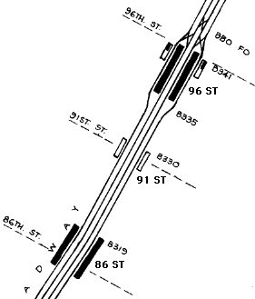
The 86 St station was extended north in 1959, although the additional entrance to the southbound platform at 87 St is much more recent, 1988. The 96 St station was extended south in 1911 and again in 1959, with a new entrance from 1959 at a point south of 94 St. |
|
|
|
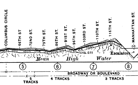
The express track is a few feet below the grade of the local track at 91 St. As shown in this detail from a profile in The New York Subway / Its Construction and Equipment, published by the Interborough Rapid Transit in 1904, the subway crests a hill at 91 St. The local tracks were brought up near street level to minimize the number of steps to the street, but the express track stays down. It has been said that the purpose of the grade is to assist braking at the station. The only other station with any such difference of grade is 33 St (6 train), where again the local tracks rise where the ground above rises. The most reasonable explanation is simply that the grade of the express tracks avoids an unnecessary climb at those points. |
|
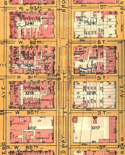
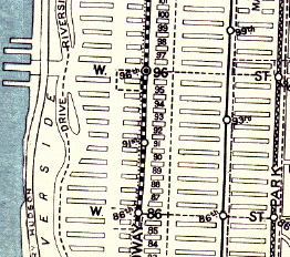
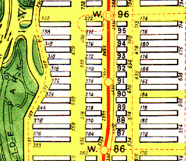
Not only was there no crosstown car at 91 St, there were even empty lots, shown here about ten years later in a Bromley Atlas of the Borough of Manhattan. The pink areas are buildings. |
The official Board of Transportation map for 1948, the Hagstrom subway map, showed 91 St. This detail is from the small size version of the map, which as a note mentioned, omitted "St" for "street". Scan by Joe Korman. For the full map, see http://www.nycsubway.org/maps/historical at the New York Subway Resources site. |
A Rand McNally street map of the 1920's shows 91 St station. There were piers at 96 St and the Hudson River, and Riverside Park was confined to a space between the Drive and the railroad, which was not yet covered by the structure as it is today. The joint 6 Ave and 9 Avenue El in Columbus Ave is shown in blue. |
The map from the Geographia Complete Street Guide of 1939 shows 91 St station. The crosstown bus lines in 86 St and 96 St are shown by dashed lines, and the streetcar in Broadway is a dotted line. The elevated line in Columbus Ave has a station at 86 St, but then jumps to 93 St and 99 St, maintaining a longer spacing than the subway. There was no 96 St crosstown route when the el was built in 1878. |
A 1945 Hagstrom street map shows 91 St station, and similarly distinguishes bus and streetcar routes by different kinds of lines. The el was closed in 1940. More detail is shown in Riverside Park, and the highway connections at 96 St are shown. There is still no obvious reason for a station at 91 St except as the halfway point between stations. Note that the wide walkway in Riverside Park is directly over the railroad structure: compare the curve at 88 St to the Rand McNally map above. |
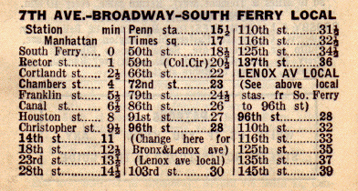
A 1935 Red Book guide lists 91 St. From the opening of the subway in 1904 until 1959, there were two local train services, to 145 St at Lenox Ave and to 137 st at Broadway, and two express trains running farther on each branch, to 180 St in the Bronx and to 242 St at Broadway. |

|
|
|
|
|
![]()