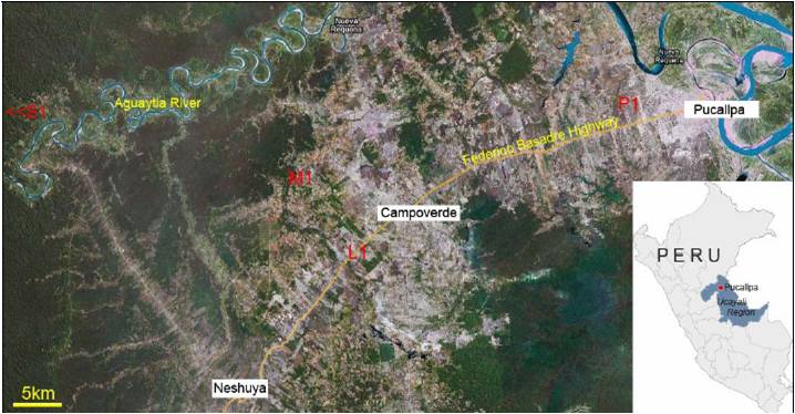
Location
The study will be centered in the province of Coronel Portillo in the Region of Ucayali. The urban center of Coronel Portillo is the city of Pucallpa (see map), located on the Ucayali River, the main transportation thoroughfare of Peruvian Amazonia and connected to Lima via the Federico Basadre Highway. Because it is a hub of transport by both road and river, Pucallpa is an important market center and has attracted migrants from around Amazonia and from the mountain and coastal regions. Facility of transport also has favored the establishment of large-scale industrial agriculture and cattle ranching, which spread from the edges of the urban zone into the smallholder agricultural landscapes located farther away by both road and river. Increasingly, many families are multi-sited, with residences in Pucallpa and in agriculturally productive rural and peri-urban zones.
We will select eight 2,500 ha study sites that represent combinations of all independent variables. Sites S1 and S2 will be landscapes with a mosaic of only smallholder fields, small pastures, and forested lands. Sites L1 and L2 will be landscapes that have been converted into large-scale agriculture and cattle ranches. Sites M1 and M2 will be located in zones where large-scale agriculture has partially encroached on a smallholder agricultural mosaic. Sites P3 and P4 will be in peri-urban areas formerly converted into large-scale agriculture and now being resettled by organized community groups. The selection of sites will be done during the first burning season (August-October) once the project has started.