Introduction
How to Use the Atlas
With the exception of this introductory section, the pictures in the
atlas are labeled and numbered as plates. Each plate consists of one or
more pictures related to the same subject, which gives it its title. A
running head at the top of page recalls the type, or family, to which the
example shown is assigned (e.g., erosional structures).
Types are defined in a broad way, and individual structures are not
further classified or listed following a systematic order; rather, they
are ordered in sequences that outline "routes" for reading. Starting with
the basic or typical features, some variants are then shown to point out
similarities and differences. Certain sequences zoom in the same object,
or phenomenon, as in the case of stratification (from a wide panoramic
view to a close-up of individual beds). In essence, an attempt is made
here to interweave the threads of a series of topics, whereas the
previous edition was organized more in the style of a deck of cards.
Because sedimentary features are found in a great variety of sizes,
geologists usually place, within the picture frame, persons or objects to
give an idea of the actual size or scale. For an average
distance (middle scale), a geologist hammer is commonly used. in
close-ups and hand specimens (small scale), a variety of objects, from a
meter to a lens cap, a coin or a paper clip, may be used.
For readers to get a correct spatial perception of the structures
shown in the photographs, which were shot from a variety of distances and
visual angles, mostly in the field but also in the lab, something must be
said about what the subjects are and how they
show up:
- in Modern sediments, just deposited and mantling a
topographic surface exposed to the atmosphere or under water (see figure
1), structures appear as morphological details of that surface. This,
however, is only a partial expression of structures, which are
three-dimensional objects, as you can see by cutting a section, or a
trench, across the depositional surface (figure 2). The sediment can be
impregnated with resins and emulsions that consolidate it and allow
coherent slices to be picked up; if the liquid simply adheres to the
surface of the grains exposed along the section, a contact replica (a
peel) can be obtained (figure 3). Sedimentary structures can thus be
taken to the lab and carefully examined in proper light conditions, or
put into exhibits;
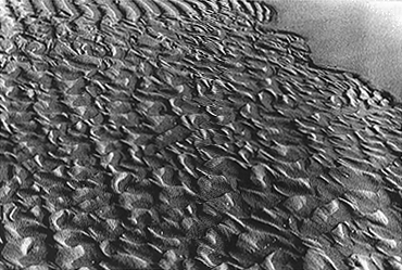
Figure 1. Ripples on the sandy
surface of a beach at low tide. These small-scale structures were formed
by waves when the beach surface was under water (upper part of photo),
and subsequently modified by the low tide. The ebb flow remolded the sand
and made its own ripples, which have a different shape (asymmetrical) and
orientation (from lower right to upper left) with respect to ripples
produced by waves. Part of the surface was completely smoothed by
shallowing water (upper right corner). Ripples are formed and canceled
many times in a day or in a week; sometimes, but rarely, they can
fossilize. Imagine that the sea level suddenly rises, submerging the
beach surface to a depth out of reach for waves. The ripples will then be
covered by mud and preserved. PHOTO G. C. PAREA
1970.
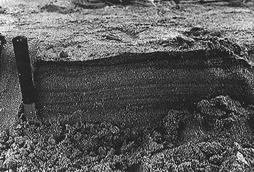
Figure 2. Lingering in the same
place (more exactly, in the part of the beach that is normally emerged)
and cutting a vertical section in the sand with a knife, one can observe
the profile of several surfaces produced by sedimentation or erosion in
recent times. Some of these surfaces are flat, others are wavy; the
former reflect the smoothing effect of waves, the latter record partly
preserved ripples. Darker and lighter bands indicate depositional laminae
and sets of laminae (organic matter, iron minerals, or other peculiar
grains are concentrated in dark laminae); their superposition underlines
the vertical accretion of the beach.
The change in geometry of the buried surfaces suggest that the
shoreline shifted a little during the time recorded by sedimentation, in
such a way that the spot we are in remained alternately in submerged and
emerged conditions. By comparing this photo with that of figure 1, you
can see that the interfacial expression of ripples is much
more evident than their cross-sectional view. Nevertheless,
ripples can be recognized in section and this is important
because scientists usually work on sections when studying Ancient
sediments. PHOTO G. C. PAREA
1970.
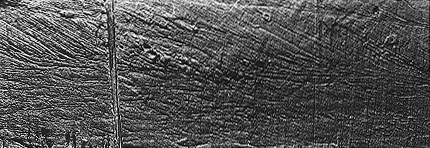
Figure 3. Mold of a section to that
of figure 2, dug in Recent sands of a Dutch tidal flat (North Sea). The
laminated sand has been impregnated with resin, which has been taken away
after drying. The structure shown is cross-lamination, changing in scale
from the lower to the upper half. Small-scale cross-laminae reveal the
formation and migration of ripples, while medium-scale laminae reflect
similar but larger structures (subaqueous dunes). PHOTO
A. COLELLA 1985.
- in Recent sediments, immediately underlying the
Modern ones and having a maximum age of 10,000 years (the conventional
time interval called Holocene, the youngest part of the Quaternary),
structures can be observed (only) in stratigraphic sections, and are part
of the stratigraphic description. Sections can be natural (e.g., river
cuts and terraces) or artificial (road-cuts, quarries). Their sizes are
quite variable, both vertically and laterally: the narrowest can be seen
in cores, cylinders of sediment or rock that are extracted from buried
sediments by various drilling and sampling devices penetrating the
sediment. Sediment cores can be 2 or more meters long but only some 10 cm
wide, and represent an almost linear, vertical record of sedimentation
(figure 4);
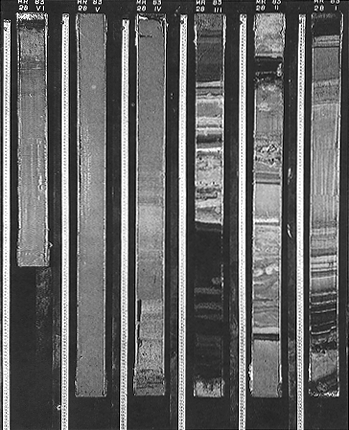
Figure 4. Sediment cores collected
in the Red Sea have been cut longitudinally to show the stratigraphy; the
top of this composite section is to the upper right. Note the change from
well-laminated (or thinly bedded) sediment in the upper portion to
relatively homogeneous, structureless sediment. All these sediments are
fine grained, and the bedding is caused by a different mechanism as
compared with previous examples (fallout from a water column instead of
lateral traction on the bottom). The dark layers have a high content in
organic matter.
Cores are cylindrical, vertical samples wrapped by a plastic liner.
Various types of sediment corers are in use; light corers (piston,
gravity, etc.) are employed to sample surficial sediments of the sea
bottom. They penetrate for some meters after being dropped from a boat.
Hard rock cores are obtained by rotary drilling equipment that cross
geologic formations hundreds of meters thick. PHOTO
COURTESY OF INSTITUTE FOR MARINE GEOLOGY C.N.R.
1983.
- in Ancient sediments, lithified to a various extent
and transformed into rocks, things can be more complicated. Surfaces
exposed by erosion, landslides or human activity, form
outcrops and may range from almost plane and even to
irregular and rugged; it depends on various factors, such as the type of
sediment or rock (lithology), the type and duration of weathering, the
orientation of the surface with respect to the wind and sun, the
erosional agent (wind, water, ice), and the chemical or mechanical action
of organisms (plant roots, lichens, etc.).
Many outcrops are markedly bidimensional and can be called
cross-sections. Sedimentary rocks can be recognized there
because of their stratified, or bedded, character; visible lines
represent the intersections between bedding planes and the plane of
section. Stratification is not always apparent, and many outcrops look
unbedded or poorly bedded. Except in arid zones, devoid of vegetation,
outcrops are generally discontinuous and separated by areas where the
rock is covered (by soil, detritus, plants, buildings, roads).
Bedding can be deformed or crushed by tectonic forces operating in the
outer, rigid earth shell (crust and lithosphere) or in the deeper mantle;
in the case of mild deformation, strata are simply tilted, or rotated
around an horizontal axis, and appear inclined with respect to their
original horizontal setting (figure 5). It is, in fact, assumed as a rule
that depositional surfaces are flat and horizontal. A secondary
inclination is, however, almost the norm for bedding as some
tectonic stresses affect, or affected to a various degree in the past,
every part of the earth's surface. In certain places, sediments are laid
down on sloping surfaces, and the beds have a primary
inclination. Secondary inclination must not be confused with
the original one, which is also called clinostratification, or
clinoforms.
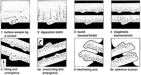
Figure 5. How sole marks are formed
and preserved (as molds). They can be used for way-up recognition in
stratigraphy: 1. bottom erosion by a current; 2. deposition starts; 3.
burial (several beds); 4. diagenesis (cementation); 5. tilting and
emergence: 5a. overturning and emergence; 6, 6a. weathering and selective
erosion. FROM RICCI LUCCHI
1970.
This tells us that the study of Ancient sediments cannot be done apart
from fundamentals of geology: sedimentary rocks are just a type of rocks,
which can have been involved in various geologic processes, and
experienced many vicissitudes after their formation.
A knowledge of the principles and rules of stratigraphy is especially
important for correctly reading and interpreting sedimentary phenomena.
Beside the assumption of original horizontality of strata,
the principle of superposition (beds at the bottom of a pile
or succession are older than those at the top) and that of
intersection (features and objects that cross or truncate
others are younger: see, for instance, fractures versus bedding in figure
6) must be taken into account. Moreover, there are way-up
criteria to establish whether beds are in normal position or upside down
(figure 5) because of tectonic movements and rotations. Every time we
geologists observe inclined strata, we should ask ourselves: are these
beds upright or overturned? In other words: are they inclined less or
more than 90° from their original position? The answer can be
provided, in many cases, by sedimentary structures, if they are present
within the beds or on their surfaces (bedding planes). If we are able to
identify the structures, their shape and orientation give us the vertical
orientation, or stratigraphic polarity, of the beds.
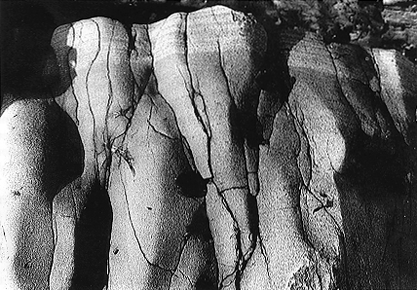
Figure 6. A sandstone bed in
vertical position. The photo has been taken from above (it crops out on a
littoral terrace); the original top is recognizable by the finer grain
size and the presence of laminae. See network of fractures (secondary
structures) almost at right angle with bedding (primary
structure).
The way-up criterion works like this: in the normal position, the
lower bedding plane, or base of a bed, faces downward, no matter how much
it is inclined; if the position is inverted, the base faces upward. It is
thus fundamental to determine whether an exposed bedding plane is the
base or the top of a bed. If you look again at figure 5, and compare
frames 5 and 5a (or 6 and 6a), this point will be made clear. Notice
also, in the same example, that you are not observing the original
structures, but molds or casts of them: depressions formed at the top of
a bed appear as relieves at the base of the overlying bed, and vice
versa. What is preserved is often the filling of a scour, not the scour
itself. This depends on the different behavior of sediments (for example,
sands interbedded with muds), when they are compacted, cemented and,
later on, weathered and eroded. Remember, then, that it would be wrong to
infer the type of structure from its present position and the orientation
of the bed in which it is found. The right procedure is just the
opposite: the original morphology and orientation of the structure must
be recognized first, then the bed orientation can be inferred.
To understand a structure, one should see where, when and how it is
formed in Modern environments, or try to reproduce it with experiments in
controlled conditions (laboratories, flumes, wind tunnels, and so on).
The implication is that one relies on the fundamental principle of
uniformity, or actualism ("the present is the key to the
past"), which is a guide for all branches of geology. That is not an
absolute rule, and should not be applied too rigidly. Processes active
today were certainly active in the geological past, but their intensity
or duration may have changed. When the vegetation did not exist on land
surfaces, the rate of erosion was higher because the bare ground had no
protection from wind or flowing water. When the atmosphere contained
little or no oxygen, the chemical alteration of rocks and the
decomposition of organic matter, which influence the rock cycle and
sedimentary processes, were different. With the evolution of the
biosphere, the interactions between organisms and abiotic components of
the environment, including sediments, became more and more intricate.
Other examples could be quoted, but these are sufficient to show that
the rate of change in earth systems has not been uniform, and that their
present condition is the result of their evolution in time. In some
respects, science says that the past is the key to the
present. It can be said geologists, endowed with imagination,
ingenuity and spirit of observation, were able to infer, from the rocks
themselves, processes that were detected or proven only later:
catastrophic floods due to collapsing of massive ice dams (e.g., Lake
Missoula in the western United States), desiccation of an entire sea (the
Mediterranean at the end of Miocene), and turbidity currents and large
submarine slides (from the observation of bedding and structures in
sandstones of the Alpine fold belts).
Thus, we geologists are all uniformitarian if that means that "past
geological events can be explained by phenomena and forces observable
today" (AGI Glossary, 1987), as the basic laws of nature have not changed
since the formation of our planet. We realize, however, that: 1) specific
processes, which are a particular expression of these laws, have changed,
especially in the biological and biochemical domains; 2) a certain dose
of "catastrophism," the old archrival of actualism, must be admitted as
far as natural phenomena are concerned.
The last point implies that actualism does not mean "every day" or
"every year" events only; there are so-called rare events occurring
sporadically, without a regular periodicity, which deliver enormous
amounts of energy over restricted areas and during short-time intervals.
These events, which are also called "catastrophic," recur over time spans
that can exceed a human life span, several generations, or the whole
human history. Large fluvial floods, tsunami waves, earthquakes of large
magnitude, and exceptional volcanic eruptions are all cases in point.
Some of these had a tremendous impact on early civilizations, and
originated legends and myths such as the submergence of Atlantis or the
Great Deluge. The human mind tends to record these natural events as
unique and to charge them with meanings and purposes known only to God.
Modern statistics tell us that the rarer the events, the bigger they
are; in other words, there is an inverse relationship between their
magnitude and their frequency (Poisson's rule). That is why no human
beings witnessed the collision of a large meteorite or comet body (but
dinosaurs did, 65 million years ago). If the average recurrence time of
such an event is, for example, 10 or 20 million years, should science say
that it represents an actualistic phenomenon or not? By applying the
concept too literally, one would be induced to consider as actualistic
only the scattered rain of micrometeorites that fall continuously on
Earth (see figure 13). On the other hand, there is a probability, however
small, that a celestial body of considerable size will impact on our
planet this year or next year: several near misses have already been
reported in the last decades. It is, therefore, more reasonable to
encompass all natural events and processes in a
uniformitarian view of the world.
After this long digression occasioned by the problems of
interpretation of Ancient sediments, I come back to more practical items
by considering the last two points:
- several structures of intermediate (meso) or small scale were
photographed on isolated blocks of rock, which detached from cliffs or
quarry walls; their orientation, in that case, has no stratigraphic
value, but can be the right one for taking a good photograph (appropriate
light incidence, etc.) and emphasizing morphological details; look, for
example, at plates 159 to 163;
- large-scale structures are rarely exposed in their entirety in
outcrops; for a better understanding of their geometry, some examples of
seismic profiles have been used (they show buried beds: see more in the
following section and plates 1 and 2); when possible, a seismic section and a
natural section have been put side by side, or in sequence, to make
comparisons easier.
Sedimentary Structures: Preliminary
Remarks
Deciphering the visible marks left by natural processes on rocks and
sediments is a fascinating part of a geologist's work; physical processes
such as currents and waves are responsible for most of these structures,
but chemical reactions and biological activity also contribute. So, even
where body fossils of organisms (shells, bones, plant remains) are
lacking, the traces of their past existence can be preserved in sediments
as a disturbance caused by their passage, metabolism, rest, or rooting.
All these marks and traces can be encompassed under the phrase
sedimentary structure; they consist of objects and forms
that are produced by sedimentary processes and are preserved in rocks.
That structures can fossilize or, in other words, have a preservation
potential, make them interesting to geologists. Some structures are very
decorative and can attract the attention of a passer-by, who perhaps
attributes them to some prank of nature. Even among scientists, not many
years ago many structures were called "hieroglyphs."
Apart from some ingenious intuitions expressed by Leonardo da Vinci,
serious attempts to understand the meaning of structures were not
undertaken until the nineteenth century when eminent geologists like C.
Lyell, H. C. Sorby, and G. K. Gilbert realized that these morphological
features of sediments and sedimentary rocks could offer clues to their
origin. This in turn could contribute to finding useful materials and
resources associated with sediments, such as coal.
A great impetus to the study of sediments and the founding of
sedimentology as a special branch of earth sciences, came from the
growing importance, after 1930, of the oil industry and mass
motorization. Hydrocarbons are intimately associated with both our life
and sediments: their source is a sediment rich in organic matter, and
their ultimate repository, or reservoir, is made of porous sedimentary
bodies. Structures are useful for understanding the environment and the
tectonic setting in which sediments are deposited and transformed into
rocks, coal, or oil. Sedimentary processes are responsible for
deposition, diagenetic processes for post-depositional
transformations.
To make the best use of structures as a tool, both their
potentialities and their limitations must be known. Among the many
structures produced in sediments, only a few are bound to preservation;
most of them are canceled by the same sedimentary processes, or by
prolonged exposure to weathering and erosion. The surface of a beach, for
example, is a sort of palimpsest (figures 1 and 2): in the emerged part,
ripples produced by wind or the tracks of our feet are flattened by high
tides or cleaners; in the submerged parts, waves continuously remold the
sandy bottom. In general, a newly deposited sediment is subject to
remobilization by various agents, especially by cataclysmic
events such as storms or gravity slides. Only when it is buried under
other sediments, can it preserve its structures. How many and which
structures will be found in the stratigraphic record depends not on a
single event but on the whole history of the sediment, including
diagenetic changes (diagenesis sometimes enhances the structures but in
other cases efface them). This history can be synthesized in the
following steps: primary deposition, remobilization, redeposition,
burial. The loop remobilization-resedimentation can be repeated
many times before arriving at the definite emplacement. When the loop is
not activated, and deposition is immediately followed by burial, the
chances of preservation of primary structures are maximized.
After burial, tectonic processes can add to diagenesis in modifying
sediments and their structures, which react to tectonic stresses with
various types of deformation. A brittle behavior is typical
of an indurated, rigid sediment; it is dismembered into blocks or slices
by ruptures and faults: within the blocks, no deformation occurs. A
ductile behavior, often but improperly called "plastic,"
means that the sediment is still relatively soft (because of its fine
grain size and water content) or was mollified by high temperatures and
pressures. Folds and shear planes represent the deformation in this case.
Shear planes can be discrete and far apart or closely spaced; in the
latter case, cleavage is produced in the rock. Cleavage and
small-scale folding are an example of pervasive deformation; an analog
for brittle materials is given by comminute fragmentation, or
brecciation. In pervasively deformed sediments, sedimentary
structures can be completely obliterated and replaced by tectonic
structures. In certain cases, small- and medium-scale tectonic
structures mimic the sedimentary ones, and attention must be paid to
avoid confusion (see, for instance, plates 177 and 178).
The static pressure due to the weight of overlying materials
contributes to the physical aspect of diagenesis in buried
sediments: water is squeezed out from pores, the solid particles come
closer, and the sediment volume decreases. Thus the sediment is
compacted; three-dimensional structures are flattened and squashed
because of compaction. The chemical aspects of diagenesis include
exchanges of matter and energy between sediment particles and
interstitial fluids: the result may be dissolution of some materials,
changes of composition, formation of new minerals, hydration or
dehydration, cementation by salts deposited in pores and cavities.
Overall, diagenetic processes tend to lithify a sediment, or transform it
into a rock (somebody speaks of lithogenesis). Buried sediments can also
be affected by heat sources, such as magma bodies, and be "cooked" or
metamorphosed. The boundary between diagenesis, as part of the
sedimentary or surficial processes, and metamorphism, is often subtle
because temperature and pressure increase gradually with depth in the
subsurface.
Not all of diagenesis is done underground, however. A fall in sea
level or a crustal uplift may bring marine sediments, still uncompacted
or unlithified, in the emerged domain, where erosional processes
predominate and can exhume them. Materials escaping erosion may then
undergo a subaerial form of diagenesis, consisting of dissolution and/or
cementation. This vadose diagenesis is caused by drastic
chemical changes in the sediment pore fluids, when meteoric water (i.e.,
slightly modified rainwater) replaces saltwater, and is transitional to
soil formation (pedogenesis).
Bedding surfaces represent discontinuities in sedimentation; before
diagenesis, they are not so obvious and the beds stick together; the
effect of diagenetic processes (compaction, differential cementation,
etc.) is to enhance the discontinuities as contrasts in physical
properties. Beds can thus be separated by both natural and artificial
causes; moreover, they send a more distinct signal when penetrated by
acoustic waves. In that case, buried beds are (seismic)
reflectors.
Several structures may be found on exposed bedding surfaces, which is
no surprise because all these surfaces were, before burial, part of the
bottoms of rivers, lakes, and seas (figure 7). In essence, they were
depositional interfaces, either subaerial (between air and
sediment) or subaqueous (between water and sediment).
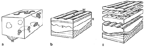
Figure 7. Orthogonal sections of
beds to show different views of sedimentary structures. In
a,traces and burrows of organisms and a basal scour fill; in
b and c, ripples, cross-laminae (foreset), and sole
marks.
Structures present on bedding planes are also visible as lines in
sections and trenches; the same object can consequently show us an
interfacial or a transfacial (cross-sectional )
view. Remember that both are an expression of the same object. Ripple
marks are among the most typical interfacial structures at the top of
beds, as shown by figures 1 and 2; structures and traces occurring at the
base of hard beds (generally as molds) are collectively called sole
marks, or basal structures, and may show a profusion of shapes.
Other depositional surfaces can form inside the beds when
sedimentation is not continuous but occurs in steps or pulses; laminae
can thus be recognized. A bed can be entirely laminated or only in part;
in the latter case, laminated is distinguished from nonlaminated, or
structureless, portions. These portions are called
intervals, horizons, or divisions. The effects of diagenesis are felt
also by all surfaces internal to beds (intrastratal ), which
become surfaces of weakness; laminated portions can thus be detached from
the others, or split into individual laminae and sets of laminae. The
rock is called fissile, or flaggy. Minor sedimentary structures can be
observed on intrastratal surfaces, or parting planes.
Finally, diagenesis can produce structures of its own within
sediments, e.g., concretions, nodules, cavity linings, or fillings. These
structures are called secondary, or diagenetic, to distinguish them from
the primary, or depositional ones. Secondary structures are discussed in
this book, but selectively; only a few examples are shown. The reason is
twofold: first, secondary structures are much more specific of a certain
material, locality, or geologic unit than primary structures, and so are
not easily amenable to categories. Only a few general types can be
recognized. Second, they tell us less about the original environment of
deposition, whereas primary structures also play the primary
role in this respect.
As said before, both bedding planes (that delimit individual beds) and
parting planes (that subdivide beds into constituent parts or laminae)
are physical discontinuities. How, then, does one tell the
one sort from the other? Is the distinction arbitrary (bedding surfaces
separate beds by definition) or real? How is it applicable in outcrops
and cores? To answer these questions, the concept of hierarchy must be
introduced. Discontinuities in sedimentation can be arranged in order of
importance according to the duration of interruption in deposition, the
amount of erosion or dissolution that occurred along them, the evenness
of the discontinuity surface, and other criteria.
In principle, bedding surfaces mark longer interruptions than
lamination surfaces do, and are thus of higher rank; this should be
reflected in their being more sharply defined in the field.
Unfortunately, such is not always the case. A bedding surface separating
two beds of the same lithology can be more subdued than the surface
separating two laminae of slightly different material. It thus seems that
some subjectivity inevitably colors any attempt to recognize a
hierarchical order among objects that involves some degree of
abstraction. If you are on a trip with a geological party, do not wait
too long to test this statement: ask everybody, in front of a suitable
outcrop, to make a distinction between groups of beds, individual beds,
and bed portions, and to sketch them in notebooks. Repeat the test at
several outcrops, and note how frequent are the disagreements between
"observations" (or, better, observers).
In spite of this limitation, let us expand a little more on the matter
of bedding hierarchy. The bed (layer, stratum) is our essential
reference. It represents the base line for both stratigraphy
(where it is the building stone of stratigraphic successions or sequences recognized. Second, they tell us less about the original environmen) and
sedimentology (it is a container of sedimentological
features, including structures, and a framework for their observation).
In classical stratigraphy, the bed has two characterizations: one is
geometrical, the other lithological. In terms of geometry, the bed is a
three-dimensional object in which two dimensions prevail on the third one
(thickness); on the other hand, it is formed by a definite rock type,
which implies that changes of lithology occur along bedding planes.
Though a geologist's eye may be struck, in different circumstances, more
by one or the other of the two aspects (the container or the content),
lithology is commonly privileged in descriptions. In a succession where,
for instance, sandstones alternate with shales (figure 8A and B) or with
conglomerates (figure 9), geologists speak of sandstone beds and shale
(or conglomerate) beds.
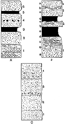
Figure 8. Definition of
stratification units (bed and layer ) in
columnar sections of clastic sediments; numbers refer to beds, lowercase
letters to internal subdivisions (when present) characterized by
different structures. A and B, alternating sandstone and
shale beds. C, sequence of amalgamated pebbly sandstone beds.
Bedding surfaces are barely visible in C and do not constitute
physical discontinuities (e.g., a barrier to vertical migration of
fluids) as in A and B.
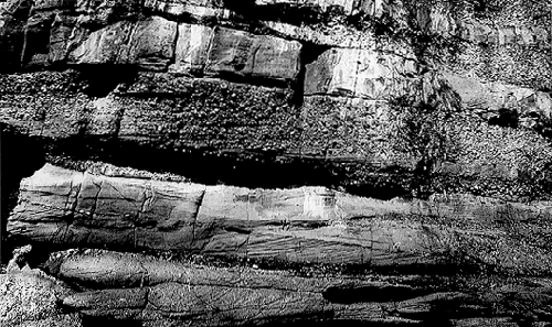
Figure 9. A set of amalgamated beds
in Ancient fluvial deposits (Devonian Old Red Sandstone, Midland Valley,
Scotland). Sandstones and conglomerates alternate vertically and, in
part, laterally. Beds are roughly parallel but lenticular and
wedge-shaped in detail. The hierarchical relation between bed and laminae
can be appreciated here. The central bed of conglomerate, for instance,
is subdivided by diagonal lines into crude, thick laminae. The laminae
form a single set extending to the whole bed. The underlying bed of
conglomeratic sandstone is composed of several sets of cross-laminae
cutting each other, i.e., a coset. The generic term cross-bedding, or
cross-stratification, can be applied to it (to indicate the style of
bedding but not its hierarchical organization). PHOTO G.
G. ORI 1992.
Sedimentologists, however, have introduced a genetic
concept of bed and bedding based on interpretation of observable features
like geometry, lithology, textures, structures, fabrics, and fossil
content. In synthesis, these features constitute the facies
of a bed or a group of beds. Facies is also a classic, albeit disputed,
concept of stratigraphy, and has been continually refined with the
progress of knowledge about sedimentary processes in Modern environments.
Today scientists know a lot about these processes, whereby the definition
of beds can lie on them, i.e., on the mode of bed emplacement. In this
respect, a bed becomes an episode, an event of
sedimentation: it is finite both in space (areal extent and thickness)
and time (deposition occurs between two pauses). Its limits may coincide
with lithological changes but are not defined by them; it is the process
of emplacement, not the materials emplaced, that defines the base and top
of a bed. Referring to figure 8, suppose that the process is represented
by turbidity currents; these flows transport suspended particles of
different size, which are stirred and mixed by turbulence. When the flow
slows down, the particles settle in order of decreasing size and weight,
forming a vertically sorted deposit, i.e., a graded bed.
Sand is concentrated at the base, mud at the top; the lower part of the
bed is sandy, the upper one is muddy. Diagenesis transforms them into
sandstone and shale or mudstone, respectively.
The alternative view is to consider two distinct beds, one made of
sand and the other of mud. Which is the best view? By applying the
lithologic criterion, you have two beds for each sedimentary event; with
the sedimentological method, there is only one bed, whose lithology
changes gradually from base to top.
One can wonder whether this is a relevant problem, or a pure question
of nomenclature. The important point here, even for practical purposes,
is to know whether a sedimentary body was made by one or more events. If
we know what the case is, we can more easily make predictions about its
lateral changes of geometry and lithology, and give a more correct
interpretation of its environment of deposition.
Assume, for example, that all mud drapes over sand beds were eroded
prior to deposition of every next sand; what you eventually get is a
monolithic body of sandstone made of similar, welded beds. If you trace
it laterally, you can see shaly intercalations between sandstone beds
appear and grow thicker and thicker; this is because you go from the
place where all mud was eroded to that where the same mud was deposited.
By comparing directly the successions at the two ends in lithological
terms only, one would say that the sandy sequence is made of just one
sandstone bed, the other of many sandstone beds. However, the number of
depositional events is the same: only their mode of preservation changes
from place to place.
The welding of beds of the same lithology requires that one looks at
details and uses all criteria of facies differentiation to recognize
bedding: every new bed can be marked, for example, by a change in grain
size, or porosity, or cementation. This is not necessarily so, however:
different beds can be made of the same materials, and be virtually
indistinguishable. The phrase more commonly used for a pile of monolithic
beds, usually separated by erosional surfaces, is amalgamated
beds.
To avoid confusion in describing and commenting on the illustrations
in this atlas, the following convention was adopted: when I speak of
individual objects, bed is used in a lithologic or otherwise
generic meaning, layer in the sedimentological meaning. The
collective terms bedding, stratification, and
layering are used interchangeably. A layer often corresponds
to a lithological couple or, less commonly, a triplet; a classical
turbidite, or a tidal layer (a deposit made by the waxing and waning of a
tidal current), is thus composed of a sandy bed and a shaly bed.
A hierarchical classification of bedding has been set up by Campbell
(1967); it has stood the test of time and is followed here. A
bedset is the local, vertical expression of a sedimentary
body made of several beds, or layers; when not otherwise specified, a
sedimentary body is meant as a multilayered unit, i.e., a bundle or
sequence of depositional events. If, observing the set from the bottom
up, you notice a certain order, a kind of rule in the succession of
strata, the set can be called a sequence or a sedimentary
cycle (there is no well-defined and agreed-upon difference
between these terms). A sequence can be defined by one or more
parameters: if the thickness of individual beds is used, the sequence can
be qualified as thinning-up or thickening-up
(figure 10); if the grain size is preferred, analogous terms are
fining-up (figure 11) and coarsening-up (figure
12). The combination of two bedsets with opposite trends gives a
symmetrical sequence (-/+ or +/-; see figure 10), with an obvious
cyclical pattern. On a descriptive basis, the asymmetrical bedsets could
be termed sequences (upper row of figure 10), the symmetrical ones termed
cycles.
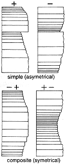
Figure 10. Bedding sequences and
facies sequences (facies are represented by types of beds) are bedsets
with a certain vertical order within them. This vertical trend is shown
by a single parameter (bed thickness, grain size) or more. Facies
characters can be synthesized by particular indexes (e.g.,
ratios between parameters: sand to mud, clastic versus nonclastic
components, etc.), which can also be useful in revealing trends. Here,
the thinning-up trend is symbolized by a plus (+) ("positive" sequence),
the thickening-up trend by a minus (-) ("negative"
sequence).
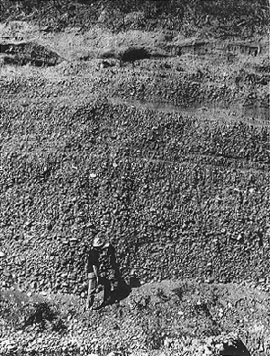
Figure 11. A bedding sequence
defined by grain size (fining-up, = FU) in alluvial sediments: it starts
from coarse gravel, ends with silty sand ("dirty sand") and is capped by
a soil horizon. Beds are amalgamated and almost undistinguishable in the
lower part. Photo taken in quarried deposits of the river Reno near
Bologna. PHOTO G. G. ORI 1992.
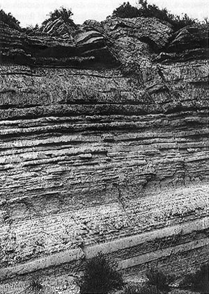
Figure 12.An example of thickening
and coarsening-up ("negative") sequence. The story is complicated here by
the occurrence of nonclastic deposits at the top (evaporitic gypsum in
large crystals). Gypsum is present also in the middle but is detrital;
thin beds at the base of the sequence are siliciclastic (siltstones and
fine sandstones). Dome-shaped deformational structures are present at the
top. This sequence is one of seven horizons of "Upper Gypsum" in the
Messinian of western Sicily.
What you observe, however, is not necessarily a continuous record of
sedimentation, but what is preserved of it; a complete cycle could have
been deposited, then erosion took away the upper half. In this way, an
asymmetrical sequence can actually record a truly cyclical phenomenon.
This is probably the main reason why the difference between sequence and
cycle has never been convincingly codified, regulated, and accepted by
the geological community (in spite of many attempts to do so, "sequence
stratigraphy" being the last and most comprehensive "legal" effort). Some
ambiguity also exists because these terms are employed for both the real
thing (the beds, the rocks) and the abstract concept (implying the
controlling process or the geologic age, i.e., the time span during which
the beds were deposited: eustatic cycles, tectonic cycles, lower
Cretaceous cycles, etc.). Perhaps, it is more precise to use them as
adjectives: sequential bedsets, sequential arrangement of
beds, cyclical bedsets, and so on. Asequential bodies, by
contrast, are those devoid of an evident vertical order in bedding; in
them, changes of bed thickness, lithology or grain size appear to be
random, at least in the field (subsequent processing of data by
statistical methods can reveal a hidden cyclicity).
Sedimentary beds, layers, and strata cannot be described in a purely
qualitative way--a specification of thickness, for instance, is required.
This can be done by direct measurement or by referring to classes of
thickness (see table 1); a scale, in centimeters or meters, must be
chosen.
Table 1. Thickness scale for beds
(layers and Laminae (in cm)
|
| Beds and
Layers | Laminae |
| >300: | extremely thick a | 3-10: | very thick
b |
| 100-300: | very thick c | 1-3: | very thick |
| 30-100: | thick | 0.3-1: | thick |
| 10-30: | medium | 0.1-0.3: | medium |
| 3-10: | thin | <0.1: | thin |
| <3: | very
thin | | |
|
| a Avoid the prefix mega
if you do not now the overall volume of beds; the estimate the volume,
you must have an idea about the areal extent of the bed and its thickness
changes. Do not judge the size of a bed from on outcrop!
b Use the term "faintly laminated," "diffuse lamination,"
"banding."
c In a certain usage, beds thicker than 1 meter are
qualified as massive: this term is not recommended as it is
also used to indicate beds devoid of internal structures.
d Many authors, following McKee and Weir (1953), put a
lower limit of 1 cm to beds; units thicker than 1 cm are called laminae.
Here, instead, a genetic-hierarchical criterion is adopted for
distinction (a lamina is sort of a bed, i.e., a subvent or elementary
unit.) |
Parting surfaces within beds, although subordinate in importance to
bedding planes, are sometimes sharp-cut and look like them; the
distinction is not always easy, especially for beginners; some practice
is needed to get a certain familiarity with these phenomena. Experience
tells that the more you learn about sedimentary structures, the less
difficult it is to understand bedding. A bed can be completely
structureless or structured; in the latter case, structures appear in the
form of laminae of variable geometry. Lamination can occur
throughout the whole bed or be localized in laminated
intervals; one or more of these intervals, or divisions, can
exist within a bed. A single laminated interval often appears in the
upper portion of a sandstone bed (figure 6), which is a useful way-up
criterion where the strata are strongly inclined or subvertical.
In between the individual lamina and the laminated interval, there is
an intermediate rank, occupied by the laminaset; this is a
genetic package of laminae that is, anyway, distinguishable from adjacent
ones on a reasonably objective basis (for example, by scour surfaces).
The genetic link among laminae in a set is demonstrated chiefly by their
parallelism, or conformity, which records an episode of
continuous sedimentation. A single set of laminae can form the whole
laminated interval (see figure 8.B2); otherwise, it consists of bundles
of sets (cosets: figure 8.A1; figure 9, lower half).
Are there lower and upper size limits to sedimentary structures? The
matter is not yet settled, and at the moment precise limits are not
established. Ordinary structures are macroscopic characters, which means
that they are recognizable with the naked eye. Morphological features
that can be observed with the help of a hand lens or a microscope (for
example, on the surface or interior of sedimentary particles: see figure
13) are more properly called microstructures. Only a passing mention is
here made of them as they are the object of other kinds of atlases (thin
sections of rocks, SEM images).
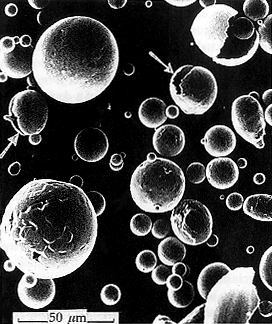
Figure 13. Magnetic spherules
(micrometeorites) in a SEM (scanning electron microscope) image.
Microstructures, related to melting, corrosion and rupture, are visible
on their surface. The spherules were extracted from a pelagic rock of
Mesozoic age. Meteorites of very small size survive the encounter with
the terrestrial atmosphere better than larger ones do. They continually
fall all over Earth but are widely dispersed and deteriorate. A
concentration of micrometeorites can occur in pelagic sediments because
of their slow rate of deposition. From Castellarin and others 1974; see
plate 171.
Half-way between micro- and macrostructures one can consider the
laminae, thin sheets of sediment that are often less than 1 mm thick
(paper-thin). Laminae are the smallest sedimentation units; they
represent an almost continuous deposition, interrupted only for some
instants or just varying in rate.
As for the upper end of the size spectrum, no stakes have been posted.
To get an idea of the largest objects to be found, imagine parachuting to
a sandy desert (an erg: see plate 24). From the plane, before the launch, you
see a rippled surface, quite similar to that you tread upon in a beach or
tidal flat. The scale, however, is different. The relief, for example, is
in the order of meters or tens of meters instead of centimeters, as you
can see from the ground. This wavy topography, extended over wide areas,
reflects the shapes of eolian dunes. Dunes are made of well-sorted fine
sand (about the size classification of sedimentary particles, see table
2). The sand is transported and accumulated by the wind, whose power and
persistence determine the dune size. On the upwind or stoss side of a
dune, the sand grains are in transit, because a high shear stress is
applied there and favors erosion or nondeposition; deposition occurs on
the downwind or lee side, the steeper one. Overall, the dune surface is a
depositional surface as the net result of the wind action is deposition,
not erosion.
Table 2. Grain size of sedimentary
particles: the Udden-Wenworth scale
|
| Size classes (mm) | Components | Aggregate |
| >256 | cobbles and boulders | rubble |
| 256-4 | pebbles | grave |
| 14-2 | granules | --- |
2-1/16
(0.063) | sand grains | sand |
| subdivisions |
| 2-1 | sand grains | very
coarse sand |
| 1-1/2 | sand grains | coarse
sand |
| 1/2-1/4 | sand grains | medium
sand |
| 1/4-1/8 | sand grains | very fine
sand |
1/16-1/256
(0.004) | sand grains | silt |
| <1/256 | clay particles (minerals) | clay |
|
Generally speaking, the morphology of sediment-fluid interfaces is
ascribed to one or more types of sedimentary structures, in particular to
so-called bed forms. In fluid dynamics language, the
topography of a depositional surface is called roughness: it influences
the behavior of a fluid moving over it and, at the same time, is
influenced by the flow. But dunes are also a form of terrestrial relief,
i.e., geomorphic features. Dunes are thus studied by sedimentologists,
hydraulic engineers, and geomorphologists. Moreover, dunes have a
considerable mass and thus can be regarded as sedimentary bodies: if you
dig a trench in one of them, you will see several superposed beds.
Sedimentary bodies are mappable units and are studied by stratigraphers.
In conclusion, what is a dune: a sedimentary structure? a geomorphic
unit? a stratigraphic unit? It can actually fall into all these
categories: it depends on the approach one chooses. The tendency to
pigeonhole natural objects is in our brain and education, not in nature.
In the academic world, disciplines and specialization proliferate and,
consequently, it is normal that the same objects are contended between
different specialists. No doubt, anyway, that dunes are sedimentary
structures, among other things: they are formed by the same processes
that produce the much smaller ripples. From the genetic point of view,
there is only a difference of scale.
Problems arise, as usual, when one tries to define and classify
things. In this case, you can see that, at the smaller end of the scale,
structures are accessories, ornaments of beds; at the larger end,
subaerial dunes, and even greater structures discovered under the sea,
have the same extent of beds, and can bound many of them. For
convenience, I shall speak of large-scale structures when I focus on the
shape, the morphology of large sedimentary objects; I shall treat them as
bodies or stratigraphic units when my focus is on their
content, architecture (internal organization), and volume.
Some large-scale structures are erosional, and truncate previous
deposits; such a truncation is shown by stratigraphic sections as an
angular or irregular contact cutting through one or more beds. An
erosional surface of large scale is a stratigraphic
discontinuity whose rank depends on what happens above it: if
it is covered by just one bed, i.e., a single sedimentary event, it is
equivalent to a bedding surface. If, on the other hand, several beds abut
against it, the surface has a higher rank, and must be regarded as an
unconformity: it remains exposed for a significant geologic
time before being buried by new strata. Unconformities have a regional
extent: this means that a single erosional structure does not suffice to
produce an unconformity. Several of them must be juxtaposed to form the
complex topography that characterizes such regional surfaces; they are,
in essence, subaerial or subaqueous landscapes of the past.
Large-scale structures and sedimentary bodies are rarely visible in
their entirety in stratigraphic sections; the size of most outcrop is
insufficient to show them. They are best displayed by seismic sections of
the subsurface, although one must be aware that a seismic image has its
own drawbacks: it is the result of instrumental processing, filtering,
etc., of elastic waves passing through receivers, and is more or less
distorted due to the use of different scales for height and distance
("vertical exaggeration").
When one looks at sediments from a short distance, one's attention is
attracted not only by structures but also by textures, i.e., by various
characters of the sediment components such as coarser and finer
particles, their shape, orientation, and spatial arrangement. The main
textural parameter, especially in clastic, or detrital
sediments (those that are carried and deposited by mechanical
forces) is the grain size: it can be inspected visually, by comparison
with grains mounted on slides or printed silhouettes, to determine the
size class of the most abundant (modal) grains. An appreciation of the
size range, or sorting, can also be cursorily made. If one wants to be
more precise, one will take samples to the laboratory and do grain size
analysis with various methods.
Notice that the terms coarse, medium, and fine are not used loosely;
they match precise size ranges according to the reference scale (table
2). This scale is based on powers of 2 and is employed also for materials
erupted explosively by volcanoes (pyroclastic deposits),
with some modifications for the specific setting (table 3). Pyroclastic
materials, although volcanic in origin, are emplaced by gravity and
superficial processes like normal sediments; beautiful structures can be
found in them, of which several examples are illustrated in this book.
Table 3. Grain-size classes of
pyroclastic deposits (from Schmid 1981, in Fisher and Schminke
1984)
|
| Size
(mm) | Components
pyroclastic particles
(general) | Aggregate
tephra, pyroclastic deposit (rock),
pyroclastite, tuff, tuffite (general) |
| >64 | blocks, bombs, cinder | agglomerate, pyroclastic breccia |
| 64-21 | lapilli | lapilli
tephra, lapillistone, lapilli tuff, lapilli tuffite |
| 2-1/16 | grains, shards | ash,
ash layer, tuff, tuffite |
| <1/16 | shards | fine ash, fine
tuff |
|
Sedimentary structures, although preserved in sediments, do not record
only sedimentation events or depositional mechanisms. Even in sedimentary
environments, where deposition is predominant, erosion can occur,
sporadically or with a relative frequency. Erosional structures,
consisting of surfaces of variable shape and size, are thus produced;
eventually, they are mantled by sediment and fossilize. It is very
important to recognize erosional surfaces, especially of medium to large
scale, because they represent breaks in sedimentation and loss of
stratigraphic record. These surfaces usually appear as lines in
cross-sections; at places, they are also exposed at the top of
substratal beds or, as molds, at the base of covering or
filling beds. Remember that, for a correct description of
rocks, surfaces must be discriminated from volumes; strata filling a
fossil channel, or paleochannel, should be quoted as a channel
fill, not simply as a channel, as is often incorrectly done.
In a stratigraphic section, geologists should speak of a channel, or
valley, only with reference to erosional surfaces which
should be: 1) visible on the outcrop and not just inferred, and 2)
correctly interpreted (not all erosional features are channels). To
recognize erosional phenomena in stratigraphic successions, the
application of the actualistic principle is essential: one needs to
observe Modern landscapes, the action of the various agents that model
them (streams, wind, glaciers, waves), and the results of this modeling
in terms of topographic and geomorphic forms.
Besides depositional and erosional structures, deformational
structures are found in sediments. The deformations I am talking about
are those occurring in the early stages of the burial history, when
sediments have undergone little diagenetic changes and are still soft
(they may be cohesionless, i.e., made of loose particles, or coherent
when particles stick together). To distinguish this kind of deformation
from that produced later, by tectonic stresses, scientists use the term
soft-sediment deformation, or
penecontemporaneous deformation. It can be caused, for
example, by creeping or sliding on slopes, expulsion of water,
liquefaction induced by seismic shocks, shrinkage due to dehydration,
etc. Practical criteria for discriminating syn-sedimentary from tectonic
deformation are difficult to generalize and are not discussed here; they
will be recalled case by case in a section of the atlas. I only remark
that deformational structures have the same variability of scale as other
types of structure.
The last group of sedimentary structures includes those produced by
the activity of organisms: they are called biogenic. Organisms play two
contrasting roles concerning sediments: constructive and destructive (or
deformative). On the one hand, they contribute to the accumulation of
sediments with their remains, both hard (shells, skeletons) and soft
(tissues, cells, organic matter). On the other, plants and animals use
soil or sediment as their home or shelter, as a source of food or simply
as a route or resting place: in some way or other, they disturb the
sediment and often obliterate structures previously formed in them. This
kind of sediment disturbance is generally called
bioturbation (or bioerosion if it affects hard rock or
lithified sediment). Organisms do not leave their remains but the traces
of their activities; when they are identifiable, these marks are called
trace fossils; when they are not (being muddled in a wholly
mixed sediment), the generic term bioturbation, or bioturbated bed
(deposit, facies), is used.
The constructive role of organisms can be active or
passive in relation to accumulation of sediment and growth
of sedimentary bodies. Coral and algal reefs are examples of active
construction (bioconstruction); accumulations of shells and shell
fragments (bioclasts), produced for example by storm waves and currents,
represent passive growth. In any case, depositional structures can be
produced, such as accretionary laminae (i.e., stromatolites, discussed
later).
We have thus reviewed the principal groups of sedimentary
structures, which correspond to the main divisions, or sections, of the
book. Specific mechanisms and modes of formation of the structures will
be discussed in the explanatory text accompanying the plates. It seems
expedient, however, before concluding these introductory remarks, to give
some general information about sedimentary processes and environments,
which are responsible for the origin of sediments and their structures.
Mention will also be made of the use of structures in "facies analysis,"
as the type of stratigraphic analysis aimed at reconstructing
paleoenvironments of deposition and erosion is termed.
Among sedimentary processes, the most important are those called
physical, or mechanical. They are almost ubiquitous over the
Earth's surface, and move huge amounts of solid matter from erosional to
depositional domains. Moreover, physical processes can entrain and
remobilize sediments accumulated by other processes; every natural or
artificial material can thus become a component of clastic sediments. It
is, therefore, logical to presume that a large amount of structures
preserved in sediments are physical in origin.
Chemical and biological processes must not be overlooked, anyway. Not
only do they play an essential part in controlling the Earth's climate,
the ecosystems and the interactions between biosphere, atmosphere,
idrosphere, and geosphere (through biogeochemical cycles, for example, or
the removal of carbon from the atmosphere), but also build up sediments.
In the geologic past, accumulation of dead organic matter and biochemical
reactions have formed imposing coal beds and oil-fields, and even larger
masses of calcium carbonate have been extracted by organisms from the
water of seas and lakes. Carbonate rocks may show specific structures
beside the whole range of types usually found in clastic rocks. After
being segregated from water and precipitated in the skeleton of
organisms, calcium carbonate is subject like any other material to
physical disgregation, transport and redeposition: it becomes a clastic
carbonate sediment. The same can be said for evaporites, the main
representative of chemical sediments: they form, in the first place, by
precipitation of salts from sea or lake water, because of evaporation.
After that, evaporitic salt crystals can be removed from their original
place and resedimented as clastic particles. The finding of physical
structures in evaporite beds gives us evidence that such a reworking
indeed occurred.
Physical processes of transport and sedimentation are to be considered
from several points of view. A first is that of the operator, or the
transporting agent, such as wind, various types of aqueous
currents, waves, and gravity flows. A transporting medium is not always
needed; when gravity directly acts on solid particles, they fall, slide,
or roll down slopes, and accumulate at their base. A planet devoid of
atmosphere or with a thin one, like Mars, can have sediments of this
type. On Earth, the atmosphere and the water masses can either act as
working fluids that entrain and carry sediment to its
resting place or as passive "spectators" of what gravity is staging (this
means that part of the fluid is entrained along with the
solid particles moved by gravity, while the rest of it stands still). In
some way or the other, the energy that is dissipated by physical
processes is gravitational, but a distinction is made between processes
directly promoted by gravity (gravity-driven ) and all
others, in which a fluid acts as a go-between
(fluid-driven ). So-called sediment gravity flows belong to
the first category.
You are now prepared to examine, more concretely, the ways sediments
are removed, transported, and deposited: fast or slowly, abruptly or
gently, a few particles at a time or en masse, etc.
In some cases, sedimentary particles travel at different velocities,
or some are moving while others remain stationary: this occurs as well in
a fluvial current, in a wind storm or under the waves approaching a
beach. The main differentiation occurs between suspended
load and bed load, i.e., between particles that
have lost contact with the ground and are supported by fluid eddies, and
particles that struggle along with difficulty near the bottom, pulled and
pushed by the flow. The former are lighter, smaller and faster (they move
at the same speed as the fluid, and make it turbid), the latter are
heavier, coarser and much slower (also because of frequent collisions and
strong friction). Individual particles in the bed load do not move
continuously but come to rest temporarily; their movement can be
described as a stop-and-go. They are also subject to a more intense wear
(fragmentation due to collisions, abrasion). The moving grains can either
roll, slide or jump; all these mechanisms (the last one is called
saltation) are encompassed by the term traction, or tractive
process.
Particles behaving differently in the same flow constitute distinct
sediment populations and will be deposited in different places; the flow
selects these populations from a parent stock produced by weathering in
source areas. Not all processes have the same efficiency in doing this
job: thereby scientists distinguish, among them, selective
from more massive types. Sedimentary structures produced by
selective flows (which can include waves) are called tractive
structures if originated in the bed load, fall-out
or settling-related structures if generated by a passing or
stationary suspension. The former are usually found in coarse sediments
(gravel to sand size), the latter in fine materials (silt to clay).
Traction and fallout can also be combined during deposition of particles
from highly turbulent suspension flows; the grain sizes involved are
intermediate between the coarser and finer end members (fine sand to
coarse silt). Traction-plus-fallout structures are common in turbidites
and deposits of fluvial floods and melt water.
Mass transport processes put in motion in a short time, often
instantaneously, consistent volumes of previously deposited sediment or
detritus covering weathered rocks. This material can be quite
heterogeneous, from stones to mud, to plant stems or branches and other
debris, or more sorted (only mud or sand, for example). It can mix with
water and form a viscous slurry, or move like a dry avalanche. Dry or
almost so mass flows occur on the flanks of volcanoes, when ejected
particles mix with hot gases to form dense clouds, heavier than the
surrounding air and driven downslope by gravity. If water is involved in
the eruption, it vaporizes.
Most mass flows are gravity-driven and occur on relatively steep
slopes, both subaerial and subaqueous. Their speed is related, on one
hand to the topographic gradient, or steepness of the slope, and to the
mass involved; on the other, to the concentration of solid particles (the
ratio between their volume and the volume of fluid), their specific
weight (which regulates their buoyancy) and their relative, or specific
surface (ratio between surface and volume, which increases with
decreasing grain size and affects frictional resistance).
Flows in which solid particles are relatively diluted in the fluid
mass move more easily, can develop turbulence and segregate their load
into subpopulations of grains. Consequently, the ensuing deposit can be
structured, at least in part: vertical size grading and laminae of
different styles can be found in it (which led to the definition of the
"Bouma sequence," figure 8.B). For higher concentrations of sediment, the
movement is slowed down by the stronger friction, both within the mass
and at its boundaries; the behavior tends to be that of a visco-plastic
material, a sort of toothpaste, and is common to water-soaked rock
debris, glacier ice and flows of viscous lava. The finer particles mix
intimately with the fluid to form a cohesive phase (like mud in water)
capable of supporting, with its strength, coarse and heavy particles:
large blocks can thus be transported at the same speed as the smaller
clasts and the mud (or equivalent matrix material). As all these
particles are entrained all together, helter-skelter, they are also
deposited in the same way. Nor is it matter of real deposition: the
flowing mass reduces its speed and "freezes"; freezing is equivalent to
the solidification of a lava, and is caused by a decrease in slope
gradient, water expulsion, or both factors (the reason is that motive
force wanes and internal friction increases).
Less dense and turbulent mass flows look like fast moving, turbid
clouds: on land, they take the aspect of dry avalanches on mountain
slopes, or of "nuées ardentes," pyroclastic flows and base surges
on the sides of volcanic cones. Sand storms in deserts and major river
floods (especially the "flash floods" of torrential streams) can have
this character but are generally slower. Under water, these phenomena
have been inferred or detected instrumentally but never observed, except
on a small scale: sediment is remobilized in shallow water by strong
storm waves or tsunami waves, and redeposited there as storm
layers or entrained in deep water by a gravity-driven
suspension cloud, a turbidity current. The excavation of
deep-water channels and canyons, the buildup of sediment in their levees
and the mantling of vast areas of the abyssal seafloor by sand and mud
containing coastal and fluvial debris, are all effects of the action of
these density currents, whose deposits are called turbidites.
The slower and more concentrated mass flows (sometimes called
hyperconcentrated) can also occur both on land and under water: in
certain cases, they are monogenic, i.e., made of a single component (mud,
sand, stones, wet snow: the coarser the particles, the stronger is the
solid friction, and the steeper the slope needed for movement), but more
commonly they are constituted by a mixture of two or more textural types
(modes ). In the latter case, the term debris
flow is used, with the exception of pyroclastic deposits: hot
ash directly emanating from volcanic vents is emplaced by pyroclastic
flows (denser, highly concentrated variety), whereas cooler ash
remobilized from slopes by rainstorms or simply gravity form so-called
lahars.
Debris flows occur in both subaerial and subaqueous environments; in
the first case, they can be directly observed, for example, on mountain
slopes and streams after heavy rains and thunderstorms. Cohesive flows
move like a paste, while a higher liquid content fluidizes the mass,
which nonetheless keeps a high viscosity and a laminar behavior.
Mass flows pick up their material from a repository
localized in a source area of some kind (snow on mountains, talus or
scree debris on valley sides, river sediment on deltas). It is thus
implicit that some other sedimentary processes (or gravity alone)
accumulated this detritus in the first place. This is a first requisite
for mass flows to occur: a causal factor acting in the long term. Another
requisite is the potential instability of the accumulated material: the
pull of gravity on slopes, the lubricating effect of melted snow, the
excess pressure of water in pores, the delayed compaction due to rapid
deposition are examples of factors that contribute to the instability of
sediment. The last requisite is the "final push": a sudden overload, a
seismic shock, a heavy storm, etc. This immediate cause, or
"trigger," is not always necessary: the least tremor in the ground or
perturbation in air or water can induce a catastrophic flow only because
the other factors had prepared suitable conditions for it. The return or
recurrence time of mass flows, in fact, has more to do with
the size of the available reservoir and the energy accumulated in it (and
hence the time required for its formation) than with the frequency of
triggering events.
Mass flows fall in the category of catastrophic events.
Some object to this term because of its affirmed anthropic implications
(it alludes to damages inflicted on human communities) and prefer
"episodic," "sporadic," "exceptional," or "rare." In addition, there is
still, among geologists, a prejudice against catastrophism dating back to
the old quarrel with actualism. To be a catastrophist implied a
philosophical view by which a divine power bears the responsibility for
major natural changes. Actualists fought this theory, among other
reasons, because it would induce an attitude of passivity and resignation
toward nature. Today, however, there is no reason to attach symbolic or
religious meanings to natural catastrophes: they do not reflect God's
wrath, but natural causes, and a better knowledge of these causes would
certainly contribute to alleviate their impact on society. Structures
indicative of catastrophic events (e.g., earthquakes) recorded in
sediments are stressed in my text, with a hint to their potential
utilization for natural hazard studies and risk analysis.
Tractive currents, fair weather waves, sluggish suspension flows, and
wind are examples of "normal," i.e., typical "actualistic" processes; the
marks left by them in sediments consist in more structures, more order,
more sorting of materials, and less erosion with respect to products of
mass flows. Normal processes operate almost continuously, though varying
in intensity with regular (tides, seasonal changes) or irregular
periodicity. The energy at stake can be much greater than that developed
by catastrophic processes (think of the enormous amount of energy stored
in seawater and dissipated by tides every day), but it is less
concentrated in both time and space. It is thus less available (which
means less valuable, in terms of quality ) to do mechanical
work. That is the reason it is said that "normal" processes produce
structures of lower energy than mass flows; this statement is not true in
absolute terms, but relative to the energy spent on a particular sediment
in a particular place.
The causal relationship between a sedimentary structure and a
sedimentary process is not always simple or straightforward. This must be
borne in mind to avoid mistakes and hurried conclusions. Some points are
here suggested as caveats:
- a structure can be produced by different processes: a typical case
is the intrastratal deformation known as convolute laminae (see plates 116-118);
- on the other hand, the same process, e.g., a subaqueous slide, can
have different effects in materials with diverse physical properties and
consolidation state;
- more than one process can combine to give a certain structure.
They can act simultaneously or in a sequence, continuously or
discontinuously;
- there are thus single event (monophasic) and multievent
(poliphasic) structures.
If the link between structure and process is complex and needs some
thinking, even less definite is the link between structure and
environment. Processes are just one of the factors and variables at play
in sedimentary environments. In many of them, for example, fluids exert a
tractive drag on sediment and form tractive structures; consequently,
tractive structures, per se, are trivial (however, their presence rules
out massive and chaotic processes). There are, fortunately, certain
structures that are more characteristic and significant than others, and
will be stressed as environmental indicators. This will be
done on a case by case basis, assuming that the reader has already a
summary knowledge of what is a river bed, a beach, or a glacier, i.e., a
natural environment in the common geographical sense.
Beside structures, there are other features in sediments and
sedimentary rocks that can be utilized as indicators: composition,
texture, fabric, etc. All these elements, which are comprised in the
concept of facies, are valuable tools for the reconstruction of Ancient
environments and geography (paleoenvironmental and paleogeographical
analysis). A geologist cannot reproduce a landscape that has vanished but
can infer and reconstruct it piece by piece, with more or less
confidence, by using fossil evidence as a clue. The more indicators that
can be discovered, the more reliable the reconstruction is.
Information on paleoenvironments and paleogeography allows us to
better understand the history of our planet and the work of its systems:
geodynamics and internal processes (magnetism, magmatism, seismicity,
plate movements), external processes and influences (solar radiation,
atmospheric and oceanic heat machines, climate, weathering, erosion,
sedimentation), biological processes, and the ecosphere. This is a noble
goal in itself, but not the only one for research.
Sedimentology can be applied to find resources (minerals, water,
energy). The analysis of sedimentary facies, for example, can elucidate
the characteristics, properties, and history of sedimentary basins, where
diverse types of economic materials can be found.
One cannot trace the subsidence history of a basin without knowing the
depth below sea level at which some critical stratigraphic levels were
deposited, and this depth must be inferred through appropriate
indicators. It is part of the "search for the paleoenvironment" game.
Basin analysis also requires that the sources, pathways, and sinks of
sediments be located. A major contribution to trace the dispersal of
sediment in Ancient basins can be given by the sedimentary structures and
the geometry of sedimentary bodies (in conjunction with compositional
data that testify to the provenance of clastic sediments). The
orientation of structures and deposits must be measured in
this respect, both in relation to present-day spatial coordinates and to
the trend of Ancient shorelines, margins of continents, mountain chains,
volcanic ridges, and so on.
The geometrical attributes of sedimentary structures (shape,
asymmetry, elongation, etc.) can be used to get the directions of
paleocurrents, paleowaves, and paleo-slopes. The orientation of
structures is reported in maps and diagrams and is a current and
essential tool in the sedimentologist kit for facies analysis. Since the
classic book by Potter and Pettijohn (1963), the operational procedure is
known, comprehensively, as paleocurrent analysis.
Let me conclude this introductory section with a remark that I deem
necessary. The present book has been conceived to help you in identifying
sedimentary structures, and to do so with a critical attitude. It is a
guide to observation, not a catalog of identical, mass-produced objects.
In geology, a recognition procedure is rarely easy and immediate because
geological objects are complex, almost unique entities. They are very
different from the more elementary objects of chemistry and physics: you
cannot tell the difference between two atoms or molecules of a certain
chemical species, but no two sand grains or two structures are ever
exactly alike in all minimum details. Each of them has a certain degree
of individuality, like persons.
For this reason, you must stop in front of each structure and think
about it for a while. Do not be satisfied with the first explanation that
comes to your mind, especially if it seems obvious. Make more than one
hypothesis, weigh and balance them, use logic in discriminating between
them. Make comparisons and use analogies (but do not rely only on them).
Make sure that your interpretations are consistent with the facts by
looking for more facts (even though they are never sufficient to
definitely prove a point). Free your fantasy and do not be afraid to
speculate, but check for internal consistency and coherence of your
speculations. Several plates in this atlas are presented as examples to
stimulate such a way of reasoning. Good reading, and good work!
References
Allen, J. R. L. 1968. On the character and classification of bed
forms. Geologie en Mijnbouw 47: 173-85.
Allen, J. R. L. 1968. Current Ripples. Amsterdam: North
Holland.
Allen, J. R. L. 1982. Sedimentary Structures: Their Character and
Physical Basis. 2 vols. Amsterdam: Elsevier.
Bosellini, A., E. Mutti, and F. Ricci Lucchi. 1991. Rocce e
successioni sedimentarie. Turin: UTET.
Bouma, A. H. 1962. Sedimentology of Some Flysch Deposits.
Amsterdam: Elsevier.
Collinson, J. D. and D. B. Thompson. 1982. Sedimentary
Structures. London: Allen & Unwin.
Campbell, C. V. 1967. Lamina, laminaset, bed, and bedset.
Sedimentology 8: 7-26.
Cas, R. A. F. and J. V. Wright. 1987. Volcanic Successions: Modern
and Ancient. London: Allen and Unwin.
Conybeare, C. E. B. and K. A. W. Crook. 1968. Manual of Sedimentary
of Sedimentary Structures. Australian Dept. Nat. Dev. Bur.
Mines Res., Geol. & Geoph. Bull. 102.
Fisher, R. V. and H.-U. Schminke. 1984. Pyroclastic
Rocks. New York: Springer-Verlag.
McKee, E. D. and G. W. Weir. 1953. Terminology for stratification and
cross-stratification in sedimentary rocks. Bull. Geol. Soc.
Amer. 64: 381-90.
Pettijohn, F. J. and P. E. Potter. 1964. Atlas and Glossary of
Sedimentary Structures. New York: Springer-Verlag.
Portmann, A. 1965. Aufbruch der Lebenforschung. Frankfurt
am Main: Suhrkamp Verlag.
Potter, P. E. and F. J. Pettijohn. 1963. Paleocurrents and Basin
Analysis. New York: Springer-Verlag.
Ricci Lucchi, F. 1970. Sedimentografia: Atlante fotografico delle
strutture primarie dei sedimenti. 1st ed. Bologna: Zanichelli.
Shrock, R. R. 1948. Sequence in Layered Rocks. New York:
McGraw-Hill.
Note. A more exhaustive list of references, based on
specialized literature, was prepared but, for reasons of space, was not
included here. It was published in the Italian journal Giornale di
Geologia (vol. 52, 1991) and is available on request at the
editor's address: Dipartimento di Scienze Geologiche (Department of
Geological Sciences), Via Zamboni 67, 40127 Bologna, Italy. Every
reference is accompanied by abbreviated information concerning the
quality of illustrations, type of data on structures (outcrops, cores,
seismic sections), sedimentary environment and facies of the unit where
the structures come from, and possible experimental setting (flumes,
etc.).
Some additional references will be found as endnotes in the plates
section.
Sedimentographica