|
EARLY
MAPS
to
about 700 CE |
SELECTIONS FROM
THE *SCHWARTZBERG
HISTORICAL
ATLAS* (DSAL, highly ZOOMABLE)
|
=*Vedic
India**
=*the
Mahajanapadas** and *the
Buddhist-Jain heartland**
=*the
India
of
the Ramayana** and *the
India
of
the Mahabharata**
=*the
Achaemenid
Empire
and the Magadhan Empire**
=*India
as
the
Greeks knew it**
=*the
Mauryan Empire**
=*Sunga
and
Indo-Greek
ascendancy, c.200 to 1 BCE**
=*the
age
of
the Kushans**
=*religious
and
cultural
sites, c.200 BCE-300 CE**
=*Western
knowledge
of
and trade with South Asia, 0-200 CE**
=*the
Gupta-Vakataka
age,
c.300-550**
=*a
synopsis: major powers of South Asia up to the 500's*
|
|
MET MUSEUM
TIMELINE
|
=*Metropolitan Museum timeline**
displays, with both maps and images (scroll down)
|
|
ANCIENT MAPS
|
Ancient maps with
commentary, by Henry Davis:
=*maps from 6,000 BCE to 400 CE**;
and *maps from 400 to 1300 CE** |
|
the ANCIENT WORLD
|
=*ancient world maps-- an overview from
Wikipedia** |
Maps by Thomas Lessman
|
=*a
global set of early maps**
|
| HUNTINGTON ARCHIVE MAPS |
=*many
excellent historical maps** |
GANDHARA at the
crossroads
|
=*the Gandhara region*--
Mahajanapada and Persian province
|
the
MAHAJANAPADAS; the BUDDHIST and JAIN HEARTLAND
|
=*the
sixteen Mahajanapadas, c.600 BCE and later
developments*
=*the
Mahajanapadas**
=*religious
movements
and
culture of the period (S)**
|
the PERSIAN
EMPIRE, c.490 BCE
|
=*the Persian
empire under Darius, 490 BCE* (up to the Indus)
=*the
Achaemenid
Empire
and the Magadhan Empire (S)**
|
|
HERODOTUS'S
WORLD, c.450 BCE
|
=*how
the world looked to Herodotus, c.450 BCE*, from *Butler and Rhys, 1907**; *comments by Henry Davis**
=*India
as
the
Greeks knew it (S)**
|
|
ALEXANDER AT THE INDUS, c.326
|
=*Alexander's
journey,
c.334-325 BCE*
=*a
quick overview* |
|
the SELEUCID
EMPIRE
|
=*the
Seleukid Empire at its maximum extent, 3rd c. BCE*
=*its
trade routes with India (a map from 1938)*
|
|
the PARTHIAN
EMPIRE
|
=*maps of Parthia, c.247 BCE-228 CE**;
and *Parthia,
c.001 CE**
|
|
the MAURYAS, and
ASHOKA
|
=*the Mauryan
empire (c.247-228 BCE), especially under Ashoka*
=*the
Mauryan
Empire
(S)**
=*religious
movements
and
culture of the period (S)** |
| the SUNGAS; the INDO-GREEKS |
=*Sunga
and
Indo-Greek
ascendancy, c.200 to 1 BCE (S)**
|
|
the KUSHAN EMPIRE
|
=*Kushan
Empire, c.100s BCE-200s CE*
=*the
age
of
the Kushans (S)** |
|
"PERIPLUS," 1st
c.
|
=*a map
based on the "Periplus of the Erythraean Sea," 1st c.
CE* |
ARRIAN
|
=*Arrian's
world (early 100's) as seen by Ortelius (1624)*
|
MAHABHARATA,
RAMAYANA
|
=*the
India
of
the Mahabharata (S)**
=*the
India
of
the Ramayana (S)**
=*"Epic
India"
and
its place names* (Wikipedia)
=*places in the Mahabharata**
(Sanskrit names, LC)
|
|
STRABO
|
=*a world map according to Strabo, c.18
CE** (Henry Davis) |
|
PTOLEMAIC MAPS,
c.200 onward
|
=*an atlas of ancient and classical
geography**
=*a Ptolemaic overview set* |
|
SCRIPT DIFFUSION
|
=*the
diffusion of South Asian scripts* in historical
times |
|
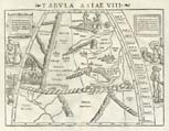
ROMAN ROADS,
300's
|
=*the Roman road
network, from the "Tabula Peutingeriana"*, 300's |
EARLY KINGDOMS
|
=*early Indian kingdoms up to 550 CE* |
|
the GUPTA EMPIRE
|
=*the Gupta
empire (300's and 400's) in its context*
=*the
Gupta-Vakataka
age,
c.300-550** |
|
HUNA EMPIRE
|
=*the empire of
the Hunas or Hephthalites, early 500's* |
|
HARSHA'S EMPIRE
|
=*Harsha's
empire, c.606-647* |
|
ISLAMIC, c.661
|
=*Muslim expansion until 661**
(Brice 1981) |
|
|
| |
GENERAL
HISTORICAL
MAPS
OF THE ANCIENT WORLD |
|
MERCATOR, 1578
|
=*Mercator's
Ptolemaic
maps, 1578*, a tribute from the inventor of the *Mercator* projection to the father
of Western map-making |
|
MALLET, 1683
|
=*Mallet's maps, c.1683-1719*--
including historical maps |
|
ANCIENT ASIA,
1700s
|
=*Various maps of the ancient world,
from the 1700's* |
|
ANCIENT ASIA,
1800s
|
=*ancient South Asia (and Asia)*,
various maps from the 1800's |
|
THE ANCIENT
WORLD (1884)
|
=*"Orbis
Terrarum"*, an elaborate map by Henry Kiepert
(1884) that shows, along with much else, "Aryan,
Semitic, and Hamitic" peoples |
|
ANCIENT WORLD
|
=*"Map of the Ancient Historical World,
Showing the Caucasian Nations"*, by I. S. Clare
(1891) |
|
A CLASSICAL
ATLAS (1907)
|
=*The Atlas of Ancient and Classical
Geography**, mostly of Europe; by Samuel Butler,
edited by Ernest Rhys (1907) |
| |
|