|
|
by Joseph Brennan. Copyright 2001, 2002. |
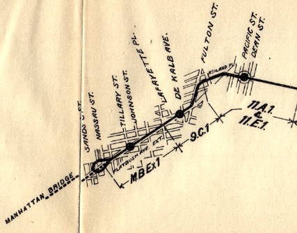
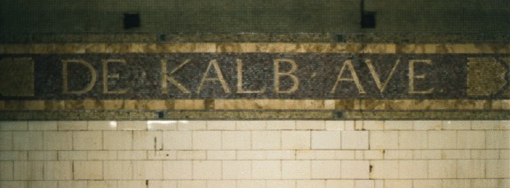
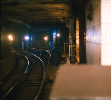
Myrtle AvePassenger service: June 1915 - July 1956.Existing abandoned portions: 1 platform (on a track in service). Touring: Q trains northbound from De Kalb Ave. Look out the front door window for the best view, or out the right side windows. It's dark. De Kalb Ave platformsPassenger service: June 1915 - 1960.Existing abandoned portions: parts of 2 island platforms (on tracks in service). Touring: Look from south end of open platforms, or from trains. construction and operationThe subway from the Manhattan Bridge south via 4 Ave was part of the same project as the Centre St loop in Manhattan, pre-dating the Dual System, called the Brooklyn Loop line. Construction began in 1909. The history of the segment from the bridge through De Kalb Ave is extremely complex, because of provisions for unbuilt routes and changes of plans during construction, and major reconstruction in 1956-1962. As originally planned, the two separate track pairs coming off the Manhattan Bridge entered a subway and became a four-track route in Brooklyn. Plans from 1908 indicate five tracks in the area of Myrtle Ave and six tracks near De Kalb Ave, with stations at Tillary St (two blocks north of Myrtle Ave) and at De Kalb Ave. A junction was built at Fulton St for a never-built branch to run via Lafayette Ave and Broadway and back to Manhattan over the Williamsburg Bridge. Provision was made near the Manhattan Bridge for a loop back to Brooklyn. The area near Myrtle Ave was redesigned in 1910 for four tracks, and the station was relocated to Myrtle Ave. At De Kalb Ave, options were left open for a connection to the first subway run by the IRT, even though the Rapid Transit Board had decided against it because building it would force giving the new subway to the IRT. The IRT main track level is near the surface, at the level of the mezzanine of De Kalb Ave station. Outbound, the connection would come off the local track at the curve just south of De Kalb Ave, and run into the lower level at Nevins St. Inbound, it would similarly come off the IRT local track just outside Nevins St, and cross over all the new route's tracks, and to allow for this, the De Kalb Ave station mezzanine does not extend to the east side of Flatbush Ave, where the connecting track would be. Once the Dual System was adopted, a junction was built north of De Kalb Ave for the route from the Montague St tunnel. The junction south of the station originally built for the Lafayette Ave subway was used instead for a connecting link to the BRT's Brighton Beach railroad. Myrtle Ave remained a local stop with side platforms, but most of the express trains over the bridge stopped there. Some express trains used the original center track pair to bypass both Myrtle Ave and De Kalb Ave. Use of the center pair was necessary to get all the rush hour trains through De Kalb Ave, but otherwise a stop at De Kalb Ave was useful to let passengers change trains. The 19th century elevated line carrying the combined Myrtle Ave El, Lexington Ave El, and 5 Ave El did not have a station over the Myrtle Ave subway station, because the street above the subway, Flatbush Ave Extension, was newly built in 1909, cutting through the blocks to connect the bridge with the end of Flatbush Ave at Fulton St. The failure of the company to build a new elevated station at what could have been a major transfer point is one of the many missed opportunities in the New York transit system. The De Kalb Ave section was the choke point for the entire BMT Broadway subway operation, with a lot of merges and some routings crossing others at grade in the swiches on both sides of the station. The maximum train capacity of the system was set here. After decades of problems, the Transit Authority began a rebuild of the area in 1956, adding some new trackage to eliminate all the grade crossings and provide places to hold trains approaching merge points. Myrtle Ave station was a casualty of the rebuild. A new track had to be added on the west side to allow for a grade-separated crossing. The original southbound "local" track at the platform had to be depressed to a lower grade to cross under, and the new track wiped out the southbound platform. The northbound platform was left in place but no longer operated. At De Kalb Ave, the platform extensions into a curve south of the station, built in 1927 to allow for longer trains, were closed and replaced by a straight extension to the north opened in 1960. The abandoned portions can be seen from the open platforms and from train windows. The 1960 extension eliminated switches at the north end of the station, so from that time, the inner face of the island platforms can be used only by trains to and from the tunnel route. The equivalent routings were provided for by new crossovers north and south of the station. |
diagram |
|
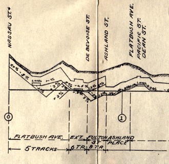
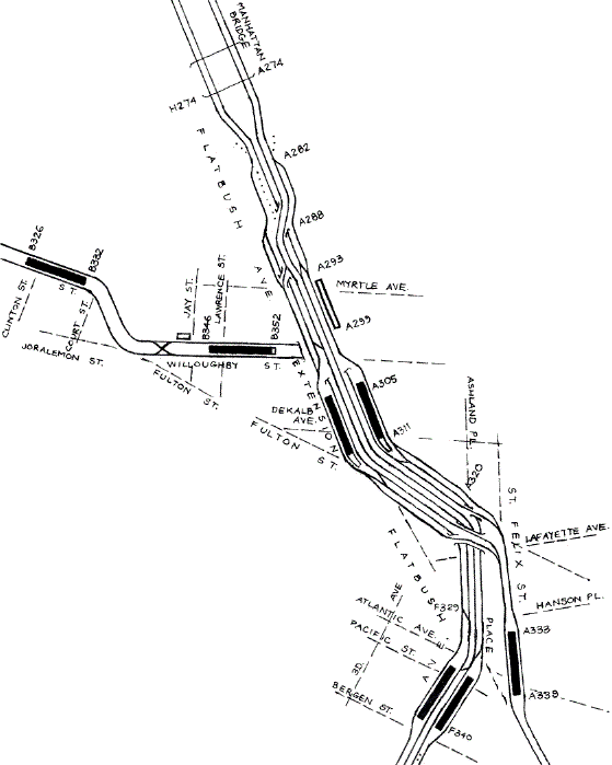
The northbound Myrtle Ave platform as originally built adjoined four tracks, of which the nearest three remain in position. The fourth has been replaced by a new track that dips below the overall grade to pass under a new crossover. Beyond it, the former southbound platform was removed to make way for a fifth track built new from 1956. There may still be some station tile in this area; it is hard to see. The old subway was built using the then new technique of re-enforced concrete, instead of the usual steel bent structure, except in the vicinity of De Kalb Ave. The newer Transit Authority work from 1956-1962 is all steel bent. South of De Kalb Ave, the Transit Authority expanded the six track subway to eight by adding a new track on each side and reconnecting the next track in. The new arrangement gives non-crossing routes from all station tracks to both the Brighton Beach and 4 Ave lines. A side effect was that Brighton Beach trains could no longer access the center pair of tracks that bypass the De Kalb Ave station. The very wide subway is located mainly under private property on the north side of Fulton St. The IRT subway occupied the space under Fulton St and Flatbush Ave at the intersection, but Fulton St is too narrow for a six track subway regardless. The letters and numbers along the lines are the chaining used to identify locations in the subway. A is the main line from Broadway, Manhattan, over the bridge and into the Brighton Beach line. H is the south side bridge tracks, and F is the Fourth Ave subway, both measured off the same chaining as A. B is the Broadway "via tunnel" route, which comes off the A chaining at Canal St in Manhattan, but has reached higher numbers here because the route is longer. The numbers are measurements to the nearest 100 feet with the last 00 dropped: A299 is 29900 feet from the zero point of A, which is at 57 St station in Manhattan. The letters and numbers can be seen marked on walls and signals. They were useful in constructing the diagram.
|
|
A detail from a Public Service Commission map and profile dated 14 February 1908 show the original plan for the line, including the loop back to Brooklyn, and the Tillary St station location. Note the five, six, and eight tracks already provided for, but with no specific purpose shown: the tunnel to Manhattan for example is not shown, nor is the proposed Lafayette Ave branch. Myrtle Ave is the unlabelled street to the right of Johnson St. Public Service Commission for the First District. From their Report. . . for the year ending December 31, 1908, Albany: the Commission, 1909. |
|
|
|
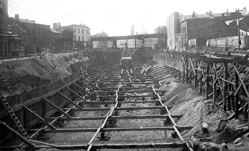
Looking south down the future Flatbush Avenue Extension in 1910, the beginnings of the Myrtle Ave station area take shape in the open cut. Work had begun in March 1910. Since the street was not needed before the Manhattan Bridge opened, the contractor was allowed the privilege of open cut construction. The standard viaduct of the el crossing overhead was soon to be replaced by a truss bridge spanning most of the new avenue. It may already be on temporary support columns here. Public Service Commission for the First District. From their Report. . . for the year ending December 31, 1910, Albany: the Commission, 1911. |
|
|
|
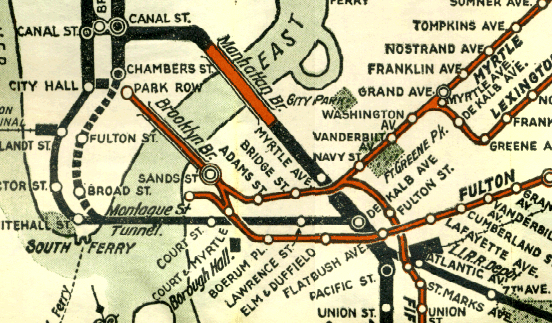
The official BMT maps distinguished aboveground lines in red and underground in solid black, and used line thickness to suggest the number of tracks. Thus the 2-track els look thin compared to the subways. The non-connection at Myrtle Ave is clearly shown. This 1924 edition was like many printed in black, green, and red. Scan by Joe Korman. For the full map, see http://www.nycsubway.org/maps/historical at the New York Subway Resources site. |
|
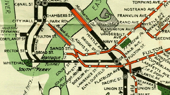
The 1939 BMT map is superficially the same as 1924, but a closer look reveals it is a completely redrawn tracing of the older one. Myrtle Ave is shown by a simple circle, designating it a local stop. Scan by Joe Korman. For the full map, see http://www.nycsubway.org/maps/historical at the New York Subway Resources site. |
|
Yet another redrawing of the same map was still being used in the early 1950's for black and white reproduction, as in phone books. The different line widths had been dropped, but now important buildings were shown by small drawings instead of block rectangles. |
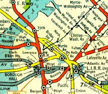
Meanwhile, the Board of Transportation had adopted the Hagstrom subway map as its official subway map, as shown here for 1948. This is the smaller of the two versions Hagstrom maintained for many years. The blue around some stations indicates transfer points to city bus lines (2 cents to the bus, 5 cents from the bus). Hagstrom showed Myrtle Ave with an express stop symbol, since express trains stopped there, and used another narrower parallel yellow line to show clearly that some trains bypassed Myrtle Ave and De Kalb Ave. Scan by Joe Korman. For the full map, see http://www.nycsubway.org/maps/historical at the New York Subway Resources site. |
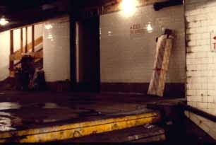
A view of the mezzanine area at Myrtle Ave. The steps go down to a landing, seen in the next image below. |
 Looking down the stairs to the platform, where the Masstransiscope has been installed. Both photos by Bill Brand, 1980. |
|
The closed Myrtle Ave platform was home for many years to an artwork called Masstransiscope by Bill Brand, installed in 1980. It was an animated cartoon, but the train moved, not the 228 hand-painted images. According to Bill, writing in 1999,
Image courtesy of Bill Brand. For more views of his work, see http://bboptics.com/masstransiscope.html. |
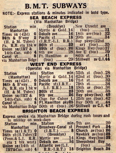
The 1935 Red Book Guide to New York listed Myrtle Ave as a stop on BMT several express trains, as "Myrtle & Gold". The station was sometimes called Gold St in some early planning documents. Gold St runs north and south at the intersection. The notation (bus) refers to transfer available to bus lines. |
|
|
|
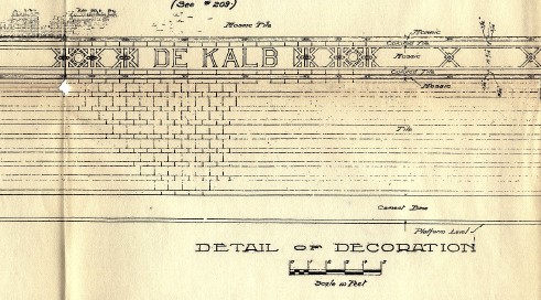
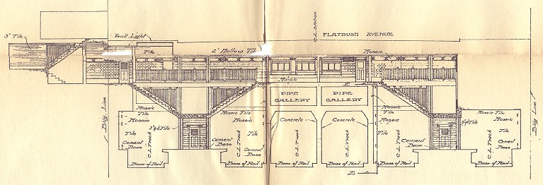
A cross section plan of De Kalb Ave, looking north, shows the mezzanine running to stairs on wthe west side of Flatbush Ave Extension, and leaving space over the eastern (righthand) side track. This space would have accommodated a track from the IRT subway at Nevins St had such a connection been built. Below, the wall decoration planned in 1908 is similar to what was installed. The style of lettering is different. Both: Public Service Commission for the First District. From their Report. . . for the year ending December 31, 1908, Albany: the Commission, 1909.
|
|
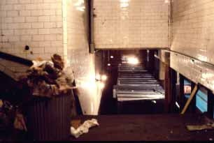
 Because of the curve, the abandoned platform ends at De Kalb Ave are visible in the gloom at the end of the open platforms. The Manhattan-bound side, above, was crudely chipped back for clearance by the 75-foot cars introduced after it was closed. The Brooklyn-bound side, left, is harder to see, but has a neatly cut back area with railings followed by a length of old platform. |
![]()