|
|
by Joseph Brennan. Copyright 2001, 2002. |
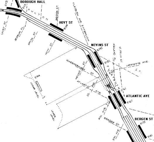
Nevins St lower levelPassenger service: Never completed.Existing abandoned portions: 1 platform and an unused trackway. Touring: 2 3 4 5 trains to Nevins St. The underpass between platforms is on the same level as the unused platform, which is directly below the Brooklyn-bound platform. Doors from it, if opened, would give a good view of the platform. construction and operationThe IRT Brooklyn line was contracted in March 1904 as a 2-track line under Fulton St expanding to 3 tracks in Flatbush Ave, to end at the Long Island Railroad terminal at Atlantic Ave. The Board of Rapid Transit Railroad Commissioners halted work in April 1905 for redesign. By that date, the tunnels had been dug out and steelwork had been installed. Work resumed in October 1905 with two additional tracks added, making 4 in Fulton St and 5 in Flatbush Ave. The additional trackways were added outside the trackways already set in place. Under the 1905 redesign, numerous provisions were made for connections to future routes. In the vicinity of Nevins St station, partially constructed as a local station on a 3-track subway, a new lower level was added underpinning the structure that had been built. The lower level had one trackway and platform in the station, with two connections on each side, all built at great cost under existing work, but none of it was ever used.
The underpass between the main platforms is the only portion of the lower level that has ever been used. Because the station was designed as a local station with side platforms, it is too close to street level for a mezzanine over the tracks. The stairs up lead to two separate fare control mezzanines located over the platforms only, with stairs up to the street. The only way between platforms inside the station is the underpass. The purpose of Nevins St lower was to allow two connections on the Brooklyn-bound local track that crossed under the other tracks. North of Nevins St, there could be a track coming from the Manhattan Bridge line (De Kalb Ave station) joining the Brooklyn-bound track. South of Nevins St, there could be a track diverging off the Brooklyn-bound track into a subway in Lafayette Ave. Running the other way, provisions were made for both the same connections in the wall alongside the main level local track. The ramp to the lower level can be seen after Hoyt St station, and the ramp back up can be seen approaching Atlantic Ave station. Track was never laid. The trackway is no longer continuous. When the Independent subway was built in 1929-1937, it was allowed to cut through the lower level. Nevins St station was opened in May 1908. It was extended toward the south in 1922 and again in 1964 reaching its present length. The lower level was probably tiled in 1918. The platform and trackway still exist but are not normally visible. |
diagram |
|
The subway was opened in May 1908 to Atlantic Ave. The extension beyond was added in the Dual System plan in 1913, and was opened in April 1919. The provisions of 1905 for future construction were: 1 East of Borough Hall: Brooklyn Bridge or second tunnel. This was the only provision used, for the Clark St tunnel (2 3 trains) opened in 1919. 2 East of Hoyt St: Ramp down to the lower level, Nevins St station lower level, ramp back up main level before Atlantic Ave. 3 West of Nevins St: Lower level trackway under main tracks to north edge of construction, and upper level removable wall. For two tracks off a Manhattan Bridge route. The BMT De Kalb Ave station was built as if this had still not been ruled out: its main track level is at the level of the IRT lower level, for the outbound track connection, and its upper mezzanine level has no structure blocking the path of a track off the IRT main level. 4 East of Nevins St: Lower level trackway under main tracks to east edge of construction, and upper level trace of provision for an opening in the side wall. For a Lafayette Ave subway. Such a subway was actually built for the IND system later. 5 West end of Atlantic Ave station: Upper level outbound local curve south into 4 Ave, and lower level crossing under main tracks to a ramp up to main level inbound local. Both are now obscured. The upper level curve is still visible in the wall of the Atlantic Ave station side platform, as extended northward in 1964. The lower level is hidden, and the ramp up is covered by the present westbound local track (2 3 trains) built 1962-1963. 6 West end of Atlantic Ave station: Upper level inbound local curve off the Long Island Railroad, and outbound curve to the Long Island Railroad. The site of the inbound trackway is still plainly visible from the north end of the inbound side platform (2 3 trains). The site of the outbound trackway was destroyed by platform extensions in 1911, and any remaining evidence by the subway extension built 1914-1919. |
|
|
|
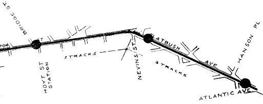
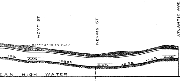
Above, a detail of a 1903 map from the Board of Rapid Transit Railroad Commissioners still shows the route as 2 and 3 tracks. Below, a profile from the same original map shows how close to the street the Brooklyn subway is. It can be seen that a lower level at Nevins St would go just below mean high water. Board of Rapid Transit Railroad Commissioners, Report. . . for the year ending December 31, 1903, New York: the Commission, 1904. |
|
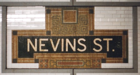
The upper level of Nevins St has a grotesquely elaborate name tablet. As if to challenge the idea that nothing could make it uglier, the recent retiling has added grey lines of tile around it. |
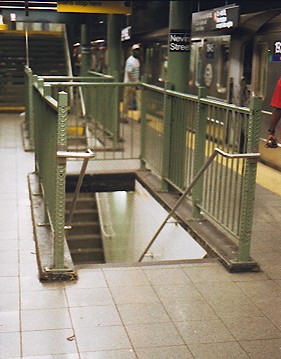
A pair of narrow stairs lead from each platform to the underpass. In the distance is the stairway up to the street: the mezzanine floor is clearly lower than the top of the train seen at right. |
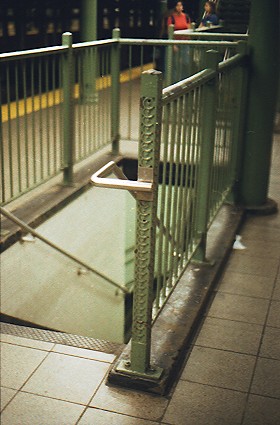
The original railing around the stairway has posts of an unusual design with loops and dots, not the expected pipe fittings, and it was sensitively retained when the station was renovated in the 1990's. The shiny handrail of course is new. A similar stair railing still exists at Canal St on the Centre St loop line (J M Z trains), which was finished in 1909, the year after Nevins St, although not opened till 1913. |
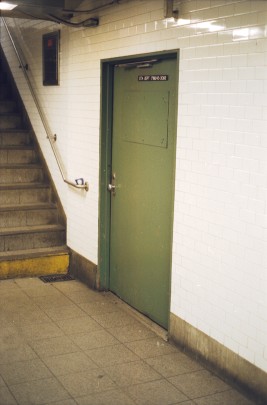
In the underpass, there are doors on each side leading to the unused platform. |
|
|
|
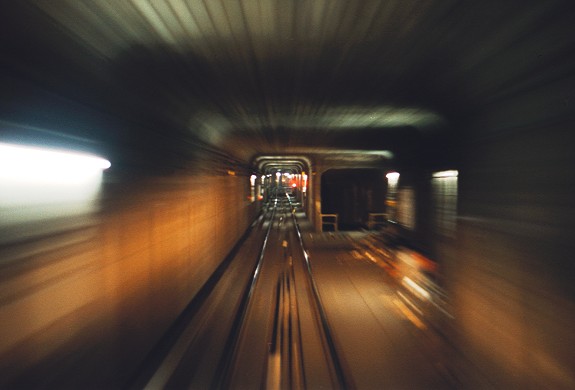
The ramp to the lower level is seen here from the front of a train running from Hoyt St to Nevins St. There would have been a switch at this point, and trains could have shifted to the right and down that darkened portal to the lower level. |

|
|
|
![]()